Riesa-Grossenhain district
| coat of arms | Germany map |
|---|---|

|

|
| Basic data (as of 2008) | |
| Existing period: | 1994-2008 |
| State : | Saxony |
| Administrative region : | Dresden |
| Administrative headquarters : | Grossenhain |
| Area : | 820.54 km 2 |
| Residents: | 111,075 (Dec. 31, 2007) |
| Population density : | 135 inhabitants per km 2 |
| License plate : | RG |
| Circle key : | 14 2 85 |
| Circle structure: | 20 municipalities |
| Address of the district administration: |
Herrmannstrasse 30–34 01558 Grossenhain |
| District Administrator : | Rainer Kutschke ( CDU ) |
| Location of the district of Riesa-Großenhain in Saxony | |
The district of Riesa-Großenhain was a district in the northeast of the Free State of Saxony from 1994 to 2008 . Neighboring districts were the Brandenburg districts of Elbe-Elster and Oberspreewald-Lausitz in the north, the former Kamenz district in the east, the former Meißen district in the south and the former Döbeln and Torgau-Oschatz districts in the west .
history
The district was created on August 1, 1994 by merging the districts of Riesa and Großenhain . On August 1, 2008, it was united with the district of Meißen (1996-2008) to form the new district of Meißen , whose district town is Meißen .
politics
The last district administrator in the Riesa-Großenhain district was Rainer Kutschke (CDU).
District council
The 54 seats in the district council were ultimately distributed among the individual parties as follows:
| Political party | Seats |
|---|---|
| CDU | 26th |
| LEFT | 12 |
| SPD | 6th |
| FDP | 4th |
| DSU | 3 |
| GREEN | 2 |
| FPD | 1 |
coat of arms
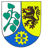
With the merger of the districts of Riesa and Großenhain to form the district of Riesa-Großenhain, a joint coat of arms became necessary in 1994. The green linden branch with a silver background, the black lion with a gold background, and the yellow gear wheel with a blue background have formed the coat of arms for the Riesa-Großenhain district since 1996.
- The green linden branch, which was included in the Riesa coat of arms as early as 1623, stands as a natural symbol for the fact that the landscape and the environment in the unified Riesa-Großenhain district are protected with great care.
- The black lion with its red reinforcement, which was already included in Grossenhain's coat of arms, also stands for the earlier affiliation of both regions to the Meissen marrow .
- The cog indicates the long industrial tradition, which mainly tells of iron and steel, textile production and mechanical engineering.
economy
The region, once a centuries-old steel location (Riesa) and an agricultural region (Grossenhain), was completely changed by the collapse of the previous economic structure after the fall of the Wall . Numerous companies have emerged since the mid-1990s, but these have not been able to compensate for the jobs that have been lost. There were last 15 industrial and commercial areas in the district.
The following companies were of national importance:
- ESF Elbe-Stahlwerke Feralpi GmbH in Riesa
- WACKER chemical plant in Nünchritz
- Pasta Riesa GmbH
- Funke & Will AG Manufacture of the YES roadster in Großenhain
- Pneumantwerke Riesa
- BuS Elektronik GmbH & Co. KG Riesa
- Kappus Seifen GmbH Riesa
- Ölwerke Riesa GmbH & Co. KG
- Riesa inland port
- STEMA Metalleichtbau GmbH Großenhain
- Polartherm Flachglas GmbH Grossenhain
- Fischbach Kunststofftechnik KG
traffic
- Leipzig – Riesa – Dresden
- Berlin – Doberlug – Kirchhain – Großenhain – Dresden
- Chemnitz-Riesa
- Chemnitz – Riesa – Berlin
- (Dresden–) Priestewitz – Großenhain Cottb. Railway station – Ruhland – Cottbus
- Riesa – Falkenberg / Elster (rail traffic stopped in December 2004)
- Riesa – Lommatzsch – Nossen (closed)
cities and communes
(Population figures as of December 31, 2006)
|
|
License Plate
On August 1, 1994, the district was assigned the GRH distinctive sign , which has been valid since January 1, 1991 for the Grossenhain district. This was replaced on January 1, 1995 by the new distinguishing mark RG , which was issued until July 31, 2008. Due to the license plate liberalization , it has been available in the Meißen district since November 9, 2012.
Until about the year 2000, vehicles from the sub-circles were given special identification numbers:
| area | Letters | numbers |
|---|---|---|
| Grossenhain district | A to L | 1 to 999 |
| AA to LZ | 1 to 99 | |
| Riesa district | M to Z | 1 to 999 |
| MA to ZZ | 1 to 99 |
Web links
literature
- The district of Riesa-Großenhain. Portrait of a region , Geiger Verlag, Horb am Neckar 1999, ISBN 3-89570-519-5

