Langelandsbelt
| Langelandsbelt | ||
|---|---|---|
| Belte and Sunde in Denmark and the southwestern Baltic Sea | ||
| Connects waters | Great Belt | |
| with water | Baltic Sea | |
| Separates land mass | Langeland | |
| of land mass | Lolland | |
| Data | ||
| Geographical location | 54 ° 55 ′ 0 ″ N , 10 ° 55 ′ 0 ″ E | |
|
|
||
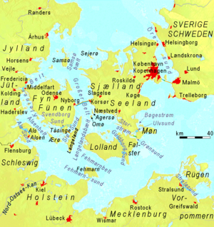
The narrow body of water between the island of Langeland and the island of Lolland is known as the Langelandsbelt ( Danish Langelandsbælt ) . At the southern end it opens to the western Baltic Sea , while at the northern end it merges into the Great Belt .
It is an important fairway for shipping on their way in or out of the eastern or southern Baltic Sea. Correspondingly, there is massive ship freight traffic and ferry traffic here. In addition to the Öresund , it is the only access for large shipping to the North Sea or to the eastern Baltic Sea, as a channel marked as Deep-Water-Way (DW) enables passage for deep-going ships.

