Laudenbach (Weikersheim)
|
Laudenbach
City of Weikersheim
|
|
|---|---|
| Coordinates: 49 ° 27 '16 " N , 9 ° 55' 41" E | |
| Height : | 270 m above sea level NHN |
| Residents : | 1162 (December 31, 2011) |
| Incorporation : | 1st January 1974 |
| Postal code : | 97990 |
| Area code : | 07934 |
|
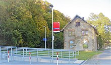
Castle with parish church in the background
|
|
Laudenbach is a southern district of Weikersheim in the Main-Tauber district in northern Baden-Württemberg .
geography
![]() Map with all coordinates of the residential areas in the district of Laudenbach: OSM
Map with all coordinates of the residential areas in the district of Laudenbach: OSM
Laudenbach lies in the lower valley of the deeply cut Vorbach almost exclusively on the right side of the river. The municipality of Laudenbach includes the village of Laudenbach ( ⊙ ) and the Bergkirche ( ⊙ ) residential area on the opposite slope of the Vorbach valley .
The Vorbach flows through at about 270 m above sea level. NN lying village of Ebertsbronner Bach to. A good one kilometer east of the village center, the Warturm used to stand on the Wartberg , a little less than a kilometer further south-east there is also the Dürrhof desert on the right slope of the tributary, only about half a kilometer southwest of the outskirts on the Mittelberg estuary that runs parallel to the longest stretch to the Vorbach north running Ebertsbronner Bach over a water reservoir the desert Schorndorf.
The district is largely open, its lowest point is on the northern edge at the outflow of the Vorbach at around 243 m above sea level. NHN , the highest almost on its eastern edge at 427.4 m above sea level. NHN .
history
The first written mention comes from the 9th century. From 1388 to 1572 the place belonged to the Lords of Finsterlohe , who had owned there before. The castle and the mountain church also go back to them.
On January 1, 1974, Laudenbach was incorporated into the city of Weikersheim.
Population development
The population of Laudenbach developed as follows:
| year | population |
|---|---|
| 1961 | 1249 |
| 1970 | 1195 |
| 2011 | 1162 |
politics
The blazon of the Laudenbach coat of arms reads: In a split shield above in silver a red clad, golden nimbly Madonna with golden hair, in her right the golden nimbly child Jesus, in the left holding an oblique left golden scepter, below in blue a silver slanting bar, occupied by three blue rings.
religion
A Jewish community already existed in Laudenbach in the Middle Ages. After an interruption, a modern Jewish community emerged in the 17th century and existed until 1939.
Culture and sights
Buildings and monuments
In the Ortsetter there is a castle from the Renaissance period , the Catholic parish church of St. Margareta and half-timbered houses. In addition, parts of the village fortifications have been preserved, including the round Herkelsturm (popular pronunciation: Hergelsdure) from the 15th century.
Best known is the gothic mountain church of the Sorrowful Mother of God , located west on the other side of the Vorbach at the end of the steep Laudenbacher Kreuzweg , a pilgrimage church whose foundation stone was laid in 1412 and to which Eduard Mörike dedicated his poem Bei der Marien-Bergkirche . It contains the tumba graveyard by Melchior von Hatzfeldt , made by Achilles Kern in 1685 , in which, however, only his heart was buried while his body is buried in Prausnitz .
Biking and hiking trails
The approximately 180 km long Jakobsweg Main-Taubertal leads through Laudenbach.
traffic
Laudenbach can be reached from the north and south via the L 1001 , which crosses the town. In the local area, the L 1001 is referred to as Weikersheimer Straße in the north , Bachstraße in the center and Niederstetter Straße in the south . The town can be reached from the east and west via the K 2857 . In the village, K 2857 is referred to as Mörikestrasse in the east , Am Markt in the center and Marienstraße in the west .
The Crailsheim – Königshofen railway line serves the place with the Laudenbach (Württ) stop .
Personalities
Individual evidence
- ↑ Geography according to Geoportal Baden-Württemberg ( references ).
- ^ Federal Statistical Office (ed.): Historical municipality directory for the Federal Republic of Germany. Name, border and key number changes in municipalities, counties and administrative districts from May 27, 1970 to December 31, 1982 . W. Kohlhammer, Stuttgart / Mainz 1983, ISBN 3-17-003263-1 , p. 469 .
- ↑ Population, occupation and workplace censuses in West Germany from June 6, 1961 (municipality register)
- ↑ Population, occupation and workplace censuses in West Germany from May 27, 1970 (municipal register)
- ↑ Updated data from the city of Weikersheim based on the 2011 census in the European Union (census)
- ^ Alemannia Judaica: Laudenbach (City of Weikersheim, Main-Tauber-Kreis) Jewish history / prayer hall / synagogue . Online at www.alemannia-judaica.de. Retrieved September 6, 2017.
- ↑ Jakobsweg Main-Taubertal (pilgrimage route) - wanderkompass.de. In: wanderkompass.de. Retrieved August 3, 2020 .
literature
- Max Schermann: The mountain church near Laudenbach. Their history and their art treasures. A commemorative sheet for the 500th anniversary of the foundation . Bad Mergentheim, 1912, reprint: Niederstetten, 2012, ISBN 978-3-921249-41-3 .
- ( Wolfgang Urban ): Parish Church of St. Margareta, Laudenbach . (Photos: Konrad Rainer; Rottenburg diocesan archive.) Kunstverlag Fink, Lindenberg 2007, ISBN 978-3-89870-396-3 .
Web links
- Web presence of the district (weinort-laudenbach.de)
- The mountain church of Laudenbach on kirchkunst.de
- Hatzfeld tomb in Laudenbach on vix-architekten.de
- Laudenbach at leo-bw.de


