Louder (Itz)
| volume up | ||
|
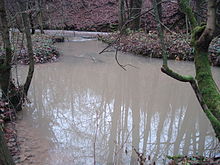
Confluence of the Lauter (left) and the drain of a spring pot (right) |
||
| Data | ||
| Water code | DE : 24164 | |
| location | Germany | |
| River system | Rhine | |
| Drain over | Itz → Main → Rhine → North Sea | |
| confluence | von Rottenbach and Weihergraben in Tremersdorf 50 ° 21 ′ 51 ″ N , 10 ° 56 ′ 45 ″ E |
|
| Source height | approx. 384 m above sea level NHN Zsfl. Weihergraben / Rottenbach | |
| Spring discharge |
MQ |
420 l / s |
| muzzle | at the Heilig-Kreuz-Kirche in Coburg in the Itz coordinates: 50 ° 15 ′ 54 " N , 10 ° 57 ′ 50" E 50 ° 15 ′ 54 " N , 10 ° 57 ′ 50" E |
|
| Mouth height | approx. 290 m above sea level NHN | |
| Height difference | approx. 94 m | |
| Bottom slope | approx. 5.1 ‰ | |
| length | 18.5 km with orienteering Weihergraben | |
| Catchment area | 102.9 km² | |
| Discharge at the Oberlauter gauge (30.8% of the catchment area) |
NNQ MNQ MQ MHQ HHQ (2003) |
175 l / s 280 l / s 970 l / s 7.44 m³ / s 14.1 m³ / s |
The Lauter (also Lauterbach ) is a right tributary of the Itz in Coburg in Bavaria .
geography
course
The Lauter arises in the municipality of Lautertal in the district of Tremersdorf through the confluence of the right Rottenbach and the left Weihergraben, which is somewhat more important in terms of both length and partial catchment area. It flows in a total of approximately south through Neukirchen and Tiefenlauter to Oberlauter . There it is reinforced by several karst springs , the source pots of the Lauter . In the further course the Lauter flows through the places Unterlauter , Bertelsdorf and Neuses . In the center of Coburg it flows into the Itz at the Holy Cross Church .
Since the end of 2012 initiates lying on top Lauter gravity stollen flood amounts of Lauter, 4 m / s exceed, in the retention basin Goldbergsee over the course of the great underflow inflow Sulzbach.
Tributaries
- Rottenbach (!) ( Right source stream )
- Weihergraben ( left source stream )
- Weisbach ( right )
- Ortelsgraben ( right )
- Maasgraben ( left )
- Flöchgraben ( left )
- Burial ( left ); Low division by Neuses
- Sulzbach ( right ), 10.7 km and 52.3 km²
- Kürengrundbach ( right )
- Rottenbach (!) ( Left )
Source pots of the Lauter
The source pots of the Lauter are located between Tiefenlauter and Oberlauter on the private property of a former fish farm ⊙ . They are used to feed the ponds. The karst springs from the Middle Muschelkalk are up to two meters deep and pour out an average of 420 liters per second. After heavy rain events , the spring water has a brownish color. The spring pots are designated by the Bavarian State Office for the Environment as geotope 473Q001. See also the list of geotopes in the district of Coburg .
Web links
Individual evidence
- ↑ a b BayernAtlas of the Bavarian State Government ( notes )
- ↑ GeoFachDatenAtlas and water services of the Bavarian State Office for the Environment
- ↑ a b c Directory of brook and river areas in Bavaria - Main river area, page 26 of the Bavarian State Office for the Environment, as of 2016 (PDF; 3.3 MB)
- ↑ Bavarian flood news service (as of September 6, 2011)
- ↑ Article in the journal Die Flussmeister , 2010 edition, page 16 PDF, accessed on January 23, 2011
- ↑ Geotope: Source pots of the Lauterbach in Lautertal (accessed on September 3, 2013; PDF; 178 kB)

