
Laxenburger Strasse (Vienna)
| Laxenburger Strasse | |
|---|---|
|
|
|
 |
|
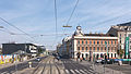
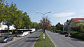
| Laxenburger Strasse near Gudrunstrasse, looking north | |
| Basic data | |
| place | Vienna |
| District | Favoriten (10th district), Liesing (23rd district; district part Inzersdorf ) |
| Created | Mentioned in 1377, expanded in 1703 |
| Newly designed | 1971 |
| Hist. Names | Tolbuchinstrasse (1946–1956) |
| Connecting roads | Favoritenstrasse , B230 |
| Cross streets | u. a. Gudrunstraße , Quellenstraße , Raxstraße |
| Places | Quellenplatz, Arthaberplatz |
| Buildings | Workers' home Favoriten , Islamic cemetery Vienna |
| use | |
| User groups | Pedestrians , cyclists , car traffic , tram lines O, 67, bus lines 66A 67A 70A |
| Road design | partly trees |
| Technical specifications | |
| Street length | 6.2 kilometers (to the city limits) |


The Laxenburger Straße runs in the 10th Vienna district, favorites in Vienna's 23rd district, Liesing , and southern in Vienna's neighboring communities Vösendorf and Biedermannsdorf in Lower Austria . It is an important exit from Vienna to the south; from Südtiroler Platz, its northern end point, to the southern city limits, it is about 6.2 km long.
The street is named after the town of Laxenburg about 8 km south of the Vienna city limits, whose castles served as the summer residence of the imperial family . It ends at the northern border of Laxenburg in the roundabout with the B11. In the municipality of Laxenburg, the street leading to the castle park is named Leopold-Figl-Straße , Wiener Straße and Hofstraße.
In terms of road law, the Vienna – Laxenburg connection has been a state road since 2002 with the number B230 (previously federal road) and 154 from the local road in Vösendorf southwards.
Course and characteristics
course
Laxenburger Straße begins at the northern boundary of the 10th district . Here, the Wiedner Gürtel , which runs in a west-east direction and is part of a main traffic artery in Vienna, passes under the Favoritenstrasse, which runs in a north-south direction , on Südtiroler Platz .
On the square, Laxenburger Straße branches off to the west at a very acute angle from Favoritenstraße , directly below the high-altitude southern railway . From the driver's perspective, this appears the other way round, since traffic to and from the square is routed in both directions through Laxenburger Strasse, while Favoritenstrasse is a pedestrian zone out of town.
The Laxenburger Straße then climbs in a southerly direction towards the height of the Wienerberg . It crosses the grid-shaped core area of Favoriten (see also Neues Landgut ) in its entirety and has more than 20 side streets and alleys on the ridge of the mountain up to Raxstrasse / Grenzackergasse. Then it descends on the southern slope of the Wienerberg as far as the bridged city motorway called the Südosttangente (no driveway) and the parallel, also bridged Donauländebahn into the Liesing valley. The district boundary 10/23 runs along the railway.
In the Liesing district of Inzersdorf , before which it crosses the Liesing , the Laxenburger Straße climbs slightly up to the city limits. Immediately south of the city limits is the Laxenburger Straße junction of the Vienna outer ring expressway S1 .
In Lower Austria, the road, leading south, crosses the slightly undulating northern Vienna Basin and crosses some streams. Neither in Vösendorf nor in Biedermannsdorf does it lead through the center of the village, but strives directly to Laxenburg, mostly through predominantly agricultural land.
Characteristic in Vienna
- Cross traffic
The arterial road, which is characterized by car traffic, is fed by several busy roads that you cross in an east-west direction. From north to south, in the 10th district, these are Gudrunstraße , Quellenstraße , Troststraße and, at the height of Wienerberg, Raxstraße or Grenzackergasse with a connection to the Südosttangente city motorway . In the 23rd district, the Draschestraße / Oberlaaer Straße street is added, which joins Laxenburger Straße.
- Public transportation
Public transport on Laxenburger Straße are:
- tram lines O (via the Vienna Central Station north-east to the 3rd and 2nd districts) and 11 (new since 2019; connection Laxenburger Straße – Quellenstraße - Reumannplatz –Favoritenstraße underground station in the 10th district),
- the two bus lines 66A (to Draschestraße) and 67A (to Kolbegasse) coming from Davidgasse and turning south into the street; In the direction of travel north from Laxenburger Strasse, turning east into Inzersdorfer Strasse,
- the bus line 70A (in Laxenburger Straße from Troststraße out of town to Richard-Tauber-Gasse at the wholesale market)
- and regional bus routes to Laxenburg and other places south of Vienna.
The tram line 6 runs across Laxenburger Strasse on Quellenstrasse (junction: Quellenplatz) and bus route 15A on Raxstrasse / Grenzackergasse. Both lines form connections to the neighboring districts to the west, northwest and east of Favoriten.
- Development
From the beginning of Laxenburger Straße to Troststraße there are still numerous buildings from the end of the 19th century or the beginning of the 20th century. This densely built-up, oldest section is interrupted by Quellenplatz and has the only green space in this area at Arthaberplatz .
Laxenburger Strasse is lined with avenue trees between Troststrasse and the 10/23 district border. From Troststrasse to Raxstrasse, communal buildings dominate , built from the 1930s to the present.
The character of the street changes from Raxstraße southwards to the district border, as in this section the houses are not directly along the street, but large housing estates were built in green areas a little further away from the street. Allotment gardens and sports fields also add to the character of this section of road.
From the crossing of the Südosttangente and the Donauländebahn onwards, the road crosses company and industrial sites and has heavy truck traffic. This impression dominates, even if the garden settlement Blumental is on the eastern side of the street . The fruit and vegetable wholesale market for Vienna has been located south of this settlement since 1972 .
history
The traffic route, mentioned in a document in 1377, was expanded in 1703 as a connecting road between the imperial castles Neue Favorita (in today's 4th district) and Laxenburg (in the southern environs of Vienna).
In Lehmann's address book for Vienna and its suburbs, which has been published since 1859, the first edition in Wieden (4th district of Vienna since 1850 ) includes a Laxenburger Allee , in 1861 also Laxenburger Strasse, then only this one. From 1861, when today's 5th district was separated from the 4th, until the 10th district was established in 1874, the district border was between the 4th district (east side of the street, odd house numbers) and the 5th district (western side of the street, even house numbers ).
In Inzersdorf (an independent municipality until 1938) the street was officially registered as Laxenburger Straße since around 1886, but it is unclear whether it was today's street of that name or today's Altmannsdorfer Straße. The name Laxenburger Allee was in use from around 1742 to 1888, and the name Laxenburger Straße in Vienna until 1894 for Altmannsdorfer Straße, which was incorporated in 1892, in the 12th district.
After the Second World War, when the 10th district north of the Donauländebahn belonged to the Soviet sector of Vienna until 1955 and the urban area south of the railway was counted as part of the Soviet-occupied zone, Lower Austria, by the occupying powers, Laxenburger Strasse became part of the 1946-1956 Commander of the victorious Red Army in the Battle of Vienna in 1945 , Marshal Fyodor Ivanovich Tolbuchin , referred to as Tolbuchinstrasse .
Since 1971 the Laxenburger Straße has been expanded in its current form as a thoroughfare.
Addresses
No. 1–5: Professor-Raimund-Jungbauer-Hof
This residential complex from 1966 has two reliefs on Laxenburger Straße depicting workers and four mosaics with motifs from the history of Vienna. Pictured are Prince Eugen , Georg Franz Kolschitzky and besieged Vienna at the time of the Second Turkish Siege , Favorita Castle and another picture shows Till Eulenspiegel .
On the first property after the junction of Laxenburger Strasse from Favoritenstrasse, the starting point for further settlement of Favoritens was between the two streets. Here Johann Mathias Steudel built an inn in 1830, popularly known as Spitzwirtshaus . Just outside the line wall , after the viaduct of the Südbahn, which has been in service since 1841 (then called the Vienna – Gloggnitzer Bahn), this restaurant became a popular resting place for carters coming to Vienna from Hungary. Later, the increasing number of workers who settled in the area frequented the area.
In 1847 the son, Johann Heinrich Steudel , took over the flourishing business and turned it into the first coffee house before the Favoriten line. After the destruction during the revolution of 1848, the property was further expanded. A (no longer existing) connecting tunnel of the railway in front of the inn was named Steudeltunnel . As a local politician, Steudel proposed the establishment of the 10th district and achieved it in 1874. He then became the first district chairman of Favoriten in 1875. The Steudelhaus existed until the Second World War, when it was badly damaged and as a result it was demolished.
No. 2A and 4: Railway building
There are still several brick halls from the end of the 19th century and an administration building from around 1910 on the large-scale operating site of the railway, which is undergoing considerable changes due to the creation of the new main train station for Vienna.
No. 8-10: Former Worker's home favorites
The former workers' home Favoriten is a remarkable example of Art Nouveau architecture in Favoriten. It was built in 1902 according to plans by the architect Hubert Gessner for the Arbeiterheim association in Favoriten and expanded in 1912 with additions. The district's first cinema and Kinderfreunde Österreich's first pub was located here .
The house was the center of the Favoritner social democracy and the scene of important political events. In 1903 a party congress of the Austrian Social Democrats took place here for the first time; in October 1933 also their last before the party ban in February 1934. Karl Kraus read from his work in the workers' home. In 1918 there were serious disputes between Victor Adler and Bolshevik workers' councils in the building. In the same year, the funeral services for the deceased Social Democrats Victor Adler and Engelbert Pernerstorfer took place here. During the civil war in 1934 , the building was occupied by government forces without resistance. After the Second World War it was the command post of the Soviet occupying power until 1951. It was then restored in 1952 by Leo Kammel junior. Later there was a hotel here. Asylum seekers were housed in the course of the refugee crisis in Europe from 2015 . Since 2019 it has been run as a basic care facility and also as an opportunity house for homeless and homeless women and families.
No. 12: Brick workers in Favoriten
On the facade of the house there is a large mosaic by Rudolf Pleban from 1955, which depicts the brick workers in Favoriten . Around 1850 and for a long time afterwards, brickworks were the most important reason for workers to settle in what would later become the 10th district. Viktor Adler's reports on the misery of the Wienerberger brickworkers were an essential motive for founding the Social Democratic Party .
No. 19: Hotel Kolbeck "zur Linde"
The house built in 1848 on the corner of Columbusplatz was bought around 1900 by Franz Kolbeck, who had it converted into a hotel and in 1903 gave it to his wife Josephine for his 60th birthday. A hotel has been run here since then. The house has a corner attachment and the facade facing Columbusplatz is structured by Hermen pilasters.
No. 34: Historicism
The residential building shows the richest historical facade decor on Laxenburger Strasse as well as a Hermen portal.
No. 36: Former Asylum Court
The modern building, decorated with a reflective glass facade, was the seat of the Asylum Court, which has been in office since 2008, until December 2013 . On January 1, 2014, this court was absorbed by the Federal Administrative Court , which has its seat in the 3rd district.
No. 43–47: Municipal District Office
→ Main article: Office building for the 10th district
No. 49–57: Zürcher Hof
The large urban residential complex with 11 staircases comprising 223 apartments (Gudrunstraße 145–149 / Columbusgasse 28–34 / Erlachgasse 100 / Laxenburger Straße) was built in 1928 by Emil Hoppe and Otto Schönthal and is a listed building. It was named after the city of Zurich in 1949 in thanks for the help from Switzerland after the Second World War . The Zurich court, whose walls are divided horizontally by symmetrical balconies and loggia is applied to a large courtyard and has at the Laxenburger road between the trays 1 and 11, a wide-bearing, lower Torbau defined by the ceramic Fries work from in 1930 by Siegfried Charoux .
No. 90A-90B: Hermine-Fiala-Hof
The residential complex was built in 1980–1982 and named in 1983 after the councilor Hermine Fiala . The apartment block, which takes up the entire block of Troststrasse 47 / Laxenburger Strasse / Dieselgasse 12-14 / Leebgasse 85-89, has 11 staircases with 398 apartments.
No. 92
The unnamed urban residential building dates from 1931/1932 and was built according to plans by Josef Hahn . Four staircases with 67 apartments are arranged around a spacious inner courtyard.
No. 94: Anton-Hölzl-Hof
The large Anton-Hölzl-Hof, named in 1983, was also built in 1931/1932 with 16 stairs and 346 apartments around a large inner courtyard. It was planned by Josef Hoffmann . The complex comprises the block of houses at Dieselgasse 7 / Laxenburger Straße / Reichenbachgasse 6 / Leebgasse 91-93 and is designed in a very restrained manner, without any special details, which already points to the upcoming austerity program of the 1930s. In the courtyard there is a large stone figurative group by Otto Fenzl from 1931, on the outer facade at the corner of Leebgasse / Reichenbachgasse there is a relief of an unidentified artist showing working men.
No. 98: Maria-and-Rudolf-Fischer-Hof
The listed urban residential complex Laxenburger Straße / Migerkastraße 2-4 / Leebgasse 95 was built in 1930/1931 according to plans by Konstantin Peller . It comprises seven staircases with 133 apartments around a large inner courtyard. The facade is structured by cornices and balconies. During the National Socialist era, the initially unnamed complex was called Otto-Planetta-Hof ; since 1949, it has been named after the communist resistance fighters Maria and Rudolf Fischer, who lived in the building and a plaque commemorates them.
No. 100; Birds and plants
At the corner of this municipal building on Migerkastraße, which has eight staircases in three building blocks on its area up to Leebgasse , there is a 48 m² sgraffito birds and plants by Brunhilde Bichler-Dreher from 1957.
Wienerfeld East and West settlement
The Wienerfeld settlement is one of the few examples of social housing from the National Socialist era in Vienna. Due to the beginning of the war, only a small part of the ambitious plans could be realized. 1939–1942 the oldest part of the settlement was built around today's Munchgasse in the east and around today's Adolf-Kirchl-Gasse in the west of Laxenburger Strasse, according to plans by the non-profit settlement and construction company GESIBA with around 500 apartments. The settlement houses were built in a uniform two-storey form along residential streets that were only named after the war. The gardens are located in the protected areas behind the living areas. In the east part of the settlement, the buildings are designed in a varied way due to the fact that they are positioned independently of the eaves or gable towards the streets and also due to the gradation of heights following the terrain. There are archways at the end of the access roads.
To the north of it, the settlement was continued from 1953–1956 according to plans by Hubert Matuschek and Anton Ubl: in the west in Laxenburger Strasse 140–142 and in the east in Laxenburger Strasse 203-207. The two- to three-story houses with pitched roofs are laid out in rows and around a courtyard and create a uniform impression. This construction phase has around 300 apartments. The architectural jewelry with reliefs above the house entrances, which mostly depict people in their jobs, is remarkable. The participating artists were Josef Franz Riedl , Konrad Calo, Anton Endstorfer , Michael Drobil , Gabriele Waldert, Josef Bock , Margarete Bistron-Lausch, Elisabeth Ziska and Emmi Hausmann-Rada.
On the west side, another 912 apartments and a school were built between 1955 and 1965. The last buildings, however, differ considerably from the original Wienerfeld settlement, as houses up to eight storeys high have now been built.
No. 255–277: Islamic Cemetery
South of the Liesing , Austria's first Islamic cemetery was built in 2008 on a vacant plot of land bounded to the north by the river, east by Großmarktstrasse and south by Haböckgasse . The funeral hall and the sanitary rooms were designed in exposed brick, the entrance is in Großmarktstraße 2A.
gallery

The beginning of Laxenburger Straße at the Wiedner Gürtel
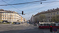
At Columbusplatz

At No. 8-10, Hotel Favorita
At the Quellenplatz

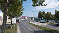
At Inzersdorfer Strasse

At Troststrasse

At Salvatorianerplatz

At Soesergasse
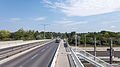
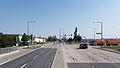
At the southeast bypass
At the Hochwassergasse
At Boschettigasse
The end of the street at Vorarlberger Allee


literature
- Herbert Tschulk: Viennese district culture guide favorites . Jugend & Volk, Vienna 1985
- Dehio Handbook Vienna. X. to XIX. and XXI. to XXIII. District . Anton Schroll, Vienna 1996
Web links
Individual evidence
- ↑ Lehmann 1859, p. 948 (= p. 954 of the digital representation )
- ^ Favorites workers' home. In: dasrotewien.at - Web dictionary of the Viennese social democracy. SPÖ Vienna (Ed.)
- ↑ AVISO June 6, 2019, 10:00 a.m .: City of Vienna and FSW open Obdach Favorita . OTS notification dated May 31, 2019, accessed May 31, 2019.
- ↑ Hotel website, History section ( Memento of the original from November 3, 2012 in the Internet Archive ) Info: The archive link was automatically inserted and not yet checked. Please check the original and archive link according to the instructions and then remove this notice.
Coordinates: 48 ° 9 ′ 23.1 ″ N , 16 ° 21 ′ 56.7 ″ E