
Lischanahütte
| Lischanahütte SAC hut |
||
|---|---|---|
 |
||
| location | Val Lischana; Graubünden , Switzerland ; Valley location: Scuol | |
| Mountain range | Münstertal Alps | |
| Regions | Sesvenna group , Engadine , Lower Engadine | |
| Geographical location: | 821.16 thousand / 183 460 | |
| Altitude | 2500 m above sea level M. | |
|
||
| owner | SAC - Engiadina Bassa section | |
| Built | 1926. Modifications in 1983 and 2003 | |
| Construction type | hut | |
| Usual opening times | Late June to mid October | |
| accommodation | 0 beds, 49 camps | |
| Winter room | 12 bearings | |
| Web link | Lischanahütte | |
| Hut directory | ÖAV DAV SAC | |

The Lischanahütte ( Rhaeto-Romanic in the idiom Vallader ) is a mountain hut belonging to the Swiss Alpine Club SAC of the Engiadina Bassa section in the canton of Graubünden in Switzerland . It is located on a rock head in Val Lischana south of Scuol at an altitude of 2500 m above sea level. M. at the foot of Piz Lischana . The hut can accommodate 49 guests in 8 rooms, each with between 4 and 11 beds and is manned in the summer season from the end of June to mid-October at the latest.
history
The Lischanahütte was built in 1926 by the SAC section Engiadina Bassa, rebuilt in 1983, and modernized and expanded in 2003. It draws surface water, which is temporarily stored in a water tank, from a small glacier above the hut. The ultra-modern toilet facility works without flushing water and chemicals. The electricity for the electric light is generated by solar systems.
Approaches
- From San Jon (bus stop, free parking) in 3 hours. Difficulty on the SAC hiking scale T2.
- From Scuol (Talort) in 4 hours. Difficulty T2.
- From S-charl (bus stop, chargeable parking spaces) via Alp Sesvenna, Fora da l'Aua, Lajet da Lischana and Fuorcla da Rims in 5½ hours. Difficulty T4, blue-white marking.
Tour possibilities
The area opens up a wide range of possibilities, especially for extended, technically rather easy hiking tours. In winter there is a very high risk of avalanches in Val Lischana.
- To S-charl via Fuorcla da Rims, Lajet da Lischana, Fora da l'Aua and Alp Sesvenna in 4½ hours. Difficulty T4 , the path is marked white-blue-white as an Alpine route .
- To Sur En (bus stop) over the Fuorcla da Rims ( 2954 m ), the plateau of the Rims lakes and the canyon path carved into the rocks through the Val d'Uina in 6 hours. Difficulty T3.
- To the Sesvennahütte AVS in South Tyrol via Fuorcla da Rims, Alp Sursass and Schlinigpass in 4½ hours. Difficulty T3-.
- To Sesvennahütte AVS via senza Cunfins 3000 (Fuorcla da Rims, Lajet da Lischana, Piz d'Immez, Piz Cristanas , Piz Rims , Schadler , Fuorcla Sesvenna) in 6½ hours. Difficulty T4.
- Sure-footed mountaineers with a head for heights can reach the summit Piz Lischana ( 3105 m ) in 2½ hours and Piz d'Immez ( 3033 m ) in 3 hours.
- The summit tours on Piz San Jon Dadaint ( 3093 m ) and Piz Triazza ( 3043 m ) are medium-difficulty climbing tours on partially brittle rock.
Web links
- Site of the hut
- Panoramic view from the Lischanahütte to the Silvretta
- Panorama from the Lischanahütte
- Report in the observer

Entrance to the Lischanahütte

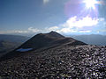
Rock head with Lischanahütte

View from the Lischanahütte to Scuol
Piz d'Immez

Lajet da Lischana

Fuorcla da Rims ( 2954 m ) with Ortler

Val d'Uina


