List of administrative levels in Bremerhaven
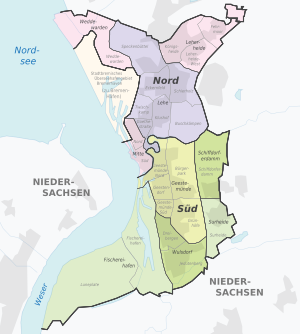
The list of administrative levels in Bremerhaven are the current division of the administration in the township Bremerhaven again
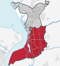
- the 2 city districts north and south as purely administrative units, which are listed in a small preceding table.
- the 9 districts .
- the 24 districts .
Townships
The city districts are sorted according to their key numbers.
- City district: states the city district that is dealt with in the corresponding line and its key number.
- District: Names the individual districts of the city district.
- Area: Indicates the total area of the city district in square kilometers as of December 31, 2013.
- Population: Indicates the total population of the municipality as of December 31, 2013.
- Population density: gives the average number of inhabitants per square kilometer in the city district as of December 31, 2013.
- Map: Illustrates the location of the city district in the city of Bremerhaven.
| Borough | Districts | surface | Residents | Population density | map |
|---|---|---|---|---|---|
|
North 1 |
44.75 km² | 65,294 | 1,459.08 inhabitants / km² |

|
|
|
South 2 |
49.09 km² | 48,854 | 955.19 inhabitants / km² |

|
Districts
The districts are sorted according to their key numbers. These are officially four digits, but the fourth digit is actually always zero. The key numbers are structured hierarchically: the first digit denotes the city district, the second digit the district and the third digit the district.
- District: Names the district that is dealt with in the corresponding line and its key number.
- Districts: Names the individual districts of the district with the associated key numbers.
- Area: Indicates the total area of the district in square kilometers as of December 31, 2013.
- Population: Indicates the total population of the district as of December 31, 2013.
- Population density: gives the average number of inhabitants per square kilometer in the district as of December 31, 2013.
- K: Name the geographic coordinates on which the district is located and with the help of which it can be found on a map. These can be called up via a link that leads to various display options.
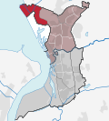
- Map: Shows the location of the district in the Bremerhaven urban area.
| district | Districts | surface | Residents | Population density | K | map |
|---|---|---|---|---|---|---|
|
Weddewarden 11 |
|
13.58 km² | 564 | 41.54 inhabitants / km² |
|

|
|
Leherheide 12 |
|
6.46 km² | 15,955 | 2,469.05 inhabitants / km² |
|

|
|
Lehe 13 |
|
16.38 km² | 36,625 | 2,236.50 inhabitants / km² |
|

|
|
Mid 14th |
|
8.33 km² | 12,150 | 1,459.46 inhabitants / km² |
|

|
|
Geestemünde 21 |
|
10.98 km² | 32,234 | 2,934.90 inhabitants / km² |
|

|
|
Schiffdorferdamm 22 |
|
4.53 km² | 2,491 | 550.01 inhabitants / km² |
|

|
|
Surheide 23 |
|
3.01 km² | 2,911 | 967.75 inhabitants / km² |
|

|
|
Wulsdorf 24 |
|
5.62 km² | 11,032 | 1,964.04 inhabitants / km² |
|

|
|
Fishing port 25 |
|
24.95 km² | 186 | 7.46 inhabitants / km² |
|

|
See also
Web links
- Official website of the municipality of Bremerhaven
- Presentation of the individual districts on Bremerhaven's official website
literature
- Herbert Black Forest : The Great Bremen Lexicon . 2nd, updated, revised and expanded edition. Edition Temmen, Bremen 2003, ISBN 3-86108-693-X .
Individual evidence
- ^ Structure of the city of Bremerhaven, scale 1: 50,000. (PDF) (No longer available online.) In: bremerhaven.de. Magistrat Bremerhaven - Vermessungs- und Katasteramt -, p. 1 , archived from the original on March 4, 2016 ; Retrieved June 9, 2015 . Info: The archive link was inserted automatically and has not yet been checked. Please check the original and archive link according to the instructions and then remove this notice.
- ↑ a b c Population level according to communal updates on December 31, 2013 (final values). (PDF) (No longer available online.) In: bremerhaven.de. City of Bremerhaven, December 31, 2013, p. 1 , archived from the original on October 11, 2016 ; Retrieved June 7, 2015 . Info: The archive link was inserted automatically and has not yet been checked. Please check the original and archive link according to the instructions and then remove this notice.
