Loeperplatz
| Loeperplatz | |
|---|---|
| Place in Berlin | |
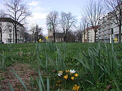
 View of Loeperplatz from the south |
|
| Basic data | |
| place | Berlin |
| District | Lichtenberg |
| Confluent streets |
Möllendorffstrasse , Scheffelstrasse, Bornitzstrasse, Rutnikstrasse, Kielblockstrasse |
| use | |
| User groups | Pedestrians , cyclists , road traffic , public transport |
| Technical specifications | |
| Square area | around 7000 m² |
The Loeperplatz is from the medieval forth previous village green space of the former village Lichtenberg, today the district of the same name of the Berlin district .
Emergence
The Loeperplatz in Alt-Lichtenberg is around 7000 m² and emerged from the fields of the former village of Lichtenberg. Around 1890 it was first given the name Wilhelmplatz after the German Emperor , under Mayor Oskar Ziethen it was renamed Loeperplatz in 1914, commemorating the Loeper family , which was important for Lichtenberg .
Location and traffic situation
The square is delimited by the directional lanes and tram tracks of Möllendorffstrasse that run around it and is divided into two by Scheffelstrasse / Bornitzstrasse. Rutnikstrasse and Kielblockstrasse also flow onto the square. The Josef Orlopp road and Storkower Straße limit the course to the north. The BVG traffic planners are striving for a straighter track across the square, but this is rejected by those responsible in the Berlin Senate because of the historical significance of the still visible old Angers.
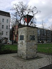
The listed old parish church Lichtenberg and the monument The Sower are located directly on Loeperplatz . In the winter of 2013, the latter was a special art object thanks to its covering: the sower's new clothes. Since 1950, there has also been a memorial for the victims of fascism on the square.
The place and its surroundings
Loeperplatz and many of its surrounding buildings are under monument protection . The houses were built between 1905 and 1959. The parsonage of the Protestant parish, built in 1848/1849, the outside staircase of which was redesigned in 2000 to meet the requirements of a historic monument, is located northeast of Loeperplatz. In addition, there is access to the Lichtenberg City Park in the southern area , and the Lichtenberg Estate Park adjoins it in the northern area . Furthermore, several senior facilities around the place offer their services.
Web links
- Loeperplatz. In: Street name lexicon of the Luisenstädtischer Bildungsverein (near Kaupert )
literature
- Institute for Monument Preservation (Ed.): The architectural and art monuments in the GDR - capital Berlin . tape II . Henschel, Berlin 1987.
- Jan Feustel : Walks in Lichtenberg . In: Berlin reminiscences . tape 75 . Haude and Spener, Berlin 1996, ISBN 3-7759-0409-3 .
Individual evidence
- ↑ Event on Monument Day 2000 ( Memento from June 1, 2005 in the Internet Archive ) (PDF; 100 kB)
- ^ Monika Arnold: Des sower's new clothes in: Webarchiv.org; accessed on January 5, 2019.
- ↑ Details on the memorial for the anti-fascist resistance fighters near Luise-Berlin
- ↑ Lichtenberg village church ;Sculpture The Sower
- ↑ Monument ensemble Loeperplatz
- ↑ Rectory
- ↑ House on Loeperplatz - the largest senior facility on Loeperplatz
Coordinates: 52 ° 31 ′ 16.2 " N , 13 ° 28 ′ 47.6" E


