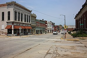
Louisiana (Missouri)
|
|
This article was on the basis of substantive defects quality assurance side of the project USA entered. Help bring the quality of this article to an acceptable level and take part in the discussion ! The following deficiencies should be corrected before this mark can be removed: No content. |
| Louisiana (Missouri) | |
|---|---|
 Downtown Louisiana |
|
| Location in Missouri | |
| Basic data | |
| Foundation : | 1816 |
| State : | United States |
| State : | Missouri |
| County : | Pike County |
| Coordinates : | 39 ° 27 ′ N , 91 ° 3 ′ W |
| Time zone : | Central ( UTC − 6 / −5 ) |
| Residents : | 3,364 (as of 2010) |
| Population density : | 414.8 inhabitants per km 2 |
| Area : | 8.86 km 2 (approx. 3 mi 2 ) of which 8.11 km 2 (approx. 3 mi 2 ) is land |
| Height : | 148 m |
| Postcodes : | 63353 |
| Area code : | +1 573 |
| FIPS : | 29-44174 |
| GNIS ID : | 0729544 |
Louisiana is a city in the northeast of the US state Missouri , on the banks of the Mississippi River . In 2010, there were 3364 residents in Louisiana.
geography
Louisiana is at the intersection of Missouri State Route 79 and US Highway 54 . The State Route follows the Mississippi River for most of its route between Hannibal and St. Charles County . US-54 crosses the river from Illinois via the Champ Clark Bridge . According to the United States Census Bureau , the city has an area of 8.86 km², of which 8.11 km² is land and 0.75 km² is water.
The district of the place is bounded in the south by Noix Creek , in the east the district boundary coincides with the border between the states of Missouri and Illinois.
sons and daughters of the town
- Claude Gillingwater (1870-1939), actor
- Lloyd C. Stark (1886–1972), politician
Individual evidence
- ↑ US Postal Service - ZIP Codes
- ↑ US Gazetteer files 2010 ( English ) United States Census Bureau. Archived from the original on February 20, 2011. Retrieved January 22, 2013.

