
Mönsterås (municipality)
| Mönsterås municipality | |||||
|---|---|---|---|---|---|
|
|||||
| State : | Sweden | ||||
| Province (län): | Kalmar Lan | ||||
| Historical Province (landskap): | Småland | ||||
| Main place: | Mönsterås | ||||
| SCB code: | 0861 | ||||
| Residents : | 13,430 (December 31, 2019) | ||||
| Area : | 608 km² (January 1, 2016) | ||||
| Population density : | 22.1 inhabitants / km² | ||||
| Website : | www.monsteras.se | ||||
| List of municipalities in Sweden | |||||


Coordinates: 57 ° 2 ' N , 16 ° 26' O Mönsterås is a municipality ( Swedish kommun ) in the Swedish province Kalmar Lan and the historical province Småland . The main town of the municipality is Mönsterås .
geography
The landscape of the community is characterized by Ice Age moraines to which the traffic routes adapt. The Baltic coast is very rugged here and stretches for about 150 kilometers. The community includes more than 300 islands that are larger than a quarter of a hectare, and countless rock domes protruding from the water. There are three nature reserves - Kungsholmen , Lövö and Vållö . The largest rivers are the 220 km long Emån and the 125 km long Alsterån .
economy
Forestry, paper industry and agriculture were the dominant industries for a long time. These continue to matter, but there are companies in other industries that have an important impact today.
Attractions
In addition to the main town Mönsterås, there are the following attractions.
Pataholm
This settlement is a well-preserved coastal town that still looks like it did in the 19th century. Pataholm was established as a trading post in the 17th century and has long been an important shipyard for Swedish sailing ships . Before the municipal reform in 1971, Pataholm was Sweden's smallest minority town ( köping ). Not far away is the Strömsrum estate, Sweden’s oldest preserved wooden castle.
Dämmans lighthouse
This lighthouse is in the middle of Kalmar Sound. The foundation and the lower part are made of granite, which was brought from the island of Blå Jungfrun in 1873 . After its decommissioning in 1969, the lighthouse was converted into a hotel with a restaurant.
Kronobäck monastery ruins
The ruins of the Kronobäck monastery are located about one kilometer south of Mönsterås. The building was built as a hospital around 1290, and in 1482 it was converted into a monastery by monks of the Order of St. John . The monks took on the obligation to help sick people. During the reign of Gustav Wasa , the religious part was shut down and the building was again a hospital until 1529, after which it fell into disrepair. The excavation of the ruins began around 1940, and today there is a medieval festival every year.
places
The following places are localities ( tatorter ):
photos
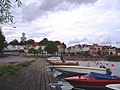
Mönsterås

Pataholm

Strömsrum Castle

Monastery ruin


Web links
- Official website (Swedish, English, German and Spanish)
Individual evidence
- ↑ Folkmängd i riket, län och kommuner December 31, 2019 at Statistiska centralbyrån
- ↑ Kommunarealer January 1, 2016 at Statistiska centralbyrån (including all inland waters)
Murderer: Blomstermåla (with Ålem ) | Blomstermåla | Emsfors (part) | Fliseryd | Mönsterås | Oknö | Timmernabben
Småorter: Finsjö | Grimhult | Habbestorp | Hammarglo | Killingeholm | Nydala | Pata malm | Sandbäckshult | Solberga och Ålem | Tålebo | Torp