
Mühlhausen (Upper Palatinate)
| coat of arms | Germany map | |
|---|---|---|
_COA.svg)
|
Coordinates: 49 ° 10 ' N , 11 ° 27' E |
|
| Basic data | ||
| State : | Bavaria | |
| Administrative region : | Upper Palatinate | |
| County : | Neumarkt in the Upper Palatinate | |
| Height : | 398 m above sea level NHN | |
| Area : | 36.98 km 2 | |
| Residents: | 5037 (Dec. 31, 2019) | |
| Population density : | 136 inhabitants per km 2 | |
| Postal code : | 92360 | |
| Area code : | 09185 | |
| License plate : | NM, PAR | |
| Community key : | 09 3 73 146 | |
| Community structure: | 24 districts | |
| Address of the municipal administration: |
Bahnhofstrasse 7 92360 Mühlhausen |
|
| Website : | ||
| Mayor : | Dr. Martin Hundsdorfer ( CSU ) | |
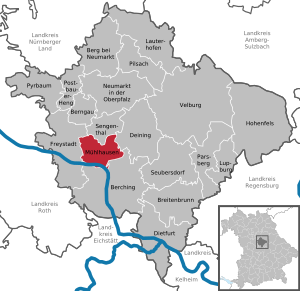
| Location of the community of Mühlhausen in the Neumarkt district in the Upper Palatinate | ||
  |
||

Mühlhausen is a municipality in the Upper Palatinate district of Neumarkt .
geography
Geographical location
The community is located 15 kilometers south of Neumarkt in the Upper Palatinate in the Sulz valley at an altitude of 398 m above sea level. NN . The subdivision is originally a typical street village along the federal highway 299, which runs from north to south . To the east, the town is closed off by the historic Ludwig-Danube-Main Canal , and to the south by the Dürrlohsee and the Main-Danube Canal . Immediately to the west, the terrain rises steeply to the 573 m high Schlüpfelberg .
Community structure
Mühlhausen has 21 districts:
|
history
Until the church is planted
The area around Mühlhausen was already inhabited by people in the Stone Age, as individual finds show. For example, a ring wall with hilltop settlements from the Bronze Age , the Urnfield and Hallstatt Period was located on the Schlüpfelberg.
Settlement was abandoned in Roman times because the Limes was only half a day's march south and times became too restless. There are also no findings from the time of the Great Migration ; they only reappear sporadically with the Carolingian period in the 6th and 7th centuries.
The place name Mühlhausen occurs several dozen times in Central Europe. The first written mention goes back to the year 900 AD. In a document dated July 26, 900 AD, Bishop Tuto from Regensburg exchanged properties at “Mulihusun” for those at Thalmässing.
Mühlhausen belonged to the imperial rule Sulzbuerg. With the extinction of the von Wolfstein , the evangelical imperial rule Sulzbürg-Pyrbaum (and with it the area of today's municipality Mühlhausen) fell in 1740/68 with all rights to spa Bavaria . Although the electoral administration tried to promote the re-Catholicization of the "Landl", the population held on to the Evangelical Lutheran creed despite some reprisals. The rule Sulzbürg-Pyrbaum established itself as the first Protestant area of spa Bavaria.
In the course of the administrative reforms in Bavaria , today's municipality was created with the municipal edict of 1818 .
Incorporations
On January 1, 1972, the previously independent municipality of Kruppach was incorporated. On July 1, 1972, Bachhausen was added from the dissolved district of Beilngries . Wappersdorf came to Mühlhausen on January 1, 1974. On January 1, 1976, the Sulzbürg market followed with parts of the Oberndorf community, which was dissolved on January 1, 1972.
Population development
Between 1988 and 2018, the municipality grew from 3,754 to 5,058 by 1,304 inhabitants or 34.7%.
politics

Municipal council
The municipal council has 16 members with the following distribution of seats:
| CSU | - | 8 seats |
| Free voters | - | 5 seats |
| The Landl list | - | 3 seats |
(As of: local elections on March 16, 2014 )
coat of arms
Blazon: “Divided by red and gold; above a silver bowl with two blue fish cut into pieces on it, below a red mill wheel below. "
The coat of arms has been used since 1977.
Community partnerships
Since 1998 the municipality has had a partnership with the Isola Vicentina municipality in Italy .
Culture and sights
_04.jpg)


Museums
Landl Museum in the Sulzbürg district, a local museum that presents the history of the region.
Architectural monuments
The Ludwig-Danube-Main Canal, built in 1846, passes near Mühlhausen. In the summer months there is the possibility of navigating the Ludwig-Danube-Main Canal with the towing ship Alma Viktoria like 150 years ago.
Jewish Cemetery
There is a Jewish cemetery in Sulzbürg .
Regular events
Every year on the first Sunday after Whitsun, the Sulzbürg family recreation and conference center, under the patronage of District Administrator Löhner, invites you to the garden summit on Sulzbürg with mostly more than 25 regional exhibitors. An extensive program, lectures to expand garden knowledge and culinary delights are offered.
Economy and Infrastructure
Established businesses
- For many years, tin toys and model railways , especially for N gauge, were manufactured in Mühlhausen by the Arnold company and delivered all over the world. Production was stopped in 2001, but the brand name was retained.
- The electrical company Dehn + Söhne has a location in Mühlhausen.
- The car Bierschneider GmbH Muehlhausen is running the parent company of a group of companies in the automobile trade, the various car dealerships in ten locations brands.
Solar park
The 6.3 megawatt solar park Mühlhausen ( Solarpark Bavaria ) is located right next to the Rhine-Main-Danube Canal and delivers around 6750 MWh of electricity per year. It is currently one of the largest solar parks in the world.
Volunteer firefighter
In the community of Mühlhausen, the volunteer fire departments Mühlhausen, Wappersdorf, Sulzbürg, Kruppach, Bachhausen and Kerkhofen provide fire protection and general help. The Mühlhausen fire brigade performs the additional function of a base fire brigade .
Born in Mühlhausen
- Johann Karl Martin Mauerer (1783–1828), first legally qualified mayor of Regensburg
- Hans Blädel (1871–1937 in Munich), folk singer and instrumental humorist, born in the Sulzbürg district
- Gustav Neustädter (* 1892; † unknown), last head of the Jewish community in Bad Kissingen, born in the Sulzbürg district
Individual evidence
- ↑ "Data 2" sheet, Statistical Report A1200C 202041 Population of the municipalities, districts and administrative districts 1st quarter 2020 (population based on the 2011 census) ( help ).
- ↑ Mühlhausen community - figures, data and facts ( Memento of the original from August 10, 2016 in the Internet Archive ) Info: The archive link was inserted automatically and has not yet been checked. Please check the original and archive link according to the instructions and then remove this notice.
- ↑ Mühlhausen Monument List, page 8 (pdf)
- ↑ Origin of the community of Mühlhausen . In: muehlhausen-sulz.de . Retrieved October 6, 2015.
- ^ Wilhelm Volkert (ed.): Handbook of Bavarian offices, communities and courts 1799–1980 . CH Beck, Munich 1983, ISBN 3-406-09669-7 , p. 533 .
- ^ Federal Statistical Office (ed.): Historical municipality directory for the Federal Republic of Germany. Name, border and key number changes in municipalities, counties and administrative districts from May 27, 1970 to December 31, 1982 . W. Kohlhammer GmbH, Stuttgart / Mainz 1983, ISBN 3-17-003263-1 , p. 649 .
- ↑ Mühlhausen solar park
Web links
- Mühlhausen (Oberpfalz) / Link catalog on the subject of Mühlhausen (Oberpfalz) at curlie.org (formerly DMOZ )
- Aerial photos of the solar park system
- Entry on the coat of arms of Mühlhausen (Upper Palatinate) in the database of the House of Bavarian History

Berching | Berg near Neumarkt in the Upper Palatinate | Berngau | Breitenbrunn | Deining | Dietfurt an der Altmühl | Freystadt | Hohenfels | Lauterhofen | Lupburg | Mulhouse | Neumarkt in the Upper Palatinate | Parsberg | Pilsach | Postbauer-Heng | Pyrbaum | Sengenthal | Seubersdorf in the Upper Palatinate | Velburg
Aumühle | Bachhausen | Belzlmühle | Ellmannsdorf | Goose Mill | Greißelbach | Herrenau | Hofen | Canal lock 28 | Canal lock 29 | Canal lock 30 | Kerkhofen | Körnersdorf | Kruppach | Mulhouse | Rice mill | Rocksdorf | Sand mill | Sulzbuerg | Cheeks | Wappersdorf | Wappersdorf (settlement) | Weihersdorf | Wettenhofen