
Machu Picchu
| Machu Picchu | |
|---|---|
|
UNESCO world heritage |
|

|
|
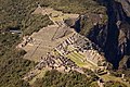
| Machu Picchu with the mountain peak of Huayna Picchu |
|
| Contracting State (s): |
|
| Type: | Culture / nature |
| Criteria : | I, III, VII, IX |
| Reference No .: | 274 |
| UNESCO region : | Latin America and the Caribbean |
| History of enrollment | |
| Enrollment: | 1983 (session 7) |
Machu Picchu [ ˌmɑtʃu ˈpiktʃu ] ( Quechua Machu Pikchu , German old summit ) is a well-preserved ruined city in Peru . The Inca built the city in the 15th century at an altitude of 2,430 meters on a ridge between the peaks of Huayna Picchu and the mountain of the same name (Machu Picchu) in the Andes above the Urubambatal in the Cusco region , 75 kilometers northwest of the city of Cusco . The terracedThe city was and is connected to the former capital of the Inca empire Cusco and the ruins of Llactapata both via a narrow mountain path with a small facility in the summit area of Huayna Picchu and via comparatively larger Inca paths .
General
Coordinates: 13 ° 9 ′ 48 ″ S , 72 ° 32 ′ 44 ″ W.


According to one theory, the city was built around 1450 on the orders of the Inca ruler Pachacútec Yupanqui , who ruled from 1438 to 1471. He laid the foundations for the expansion of the mighty Inca empire and introduced the cult around the sun god Inti .
The city comprised 216 stone buildings, which were located on terraces and connected by a system of stairs. Most of the terraces with their small water drainage openings built into the walls and around 3000 steps have also been preserved to this day, as has the canal connection from the water source outside the city to the cascading fountain basins, the outer walls of the temples and the sometimes multi-storey residential buildings. They are fully functional and, if necessary, have been gradually reconstructed in the incatypical design in recent years.
Research today assumes that the city could accommodate and supply up to 1000 people in its heyday. The complex, whose original name is unknown, was named after one of the nearby mountain peaks between which the ruined city lies. Parts of the city and the terraces used for agriculture lie at the foot of the "old summit". Behind its other end, the “young peak” ( Huayna Picchu ) rises like a sugar hat into the sky, on which there is also a small facility that was and is accessible from the city via a small mountain path. In the southeast, about 15 kilometers away in the Urubamba Valley, in the immediate vicinity of the river, are the ruins of the Inca city of Llactapata . Both settlements are still connected by an Inca trail.
Various theories have been developed about the purpose of this city. In fact, there are no records about them, which is why only more or less well-founded assumptions can be made on the basis of archaeological finds.
During the early exploration of the city complex, over 50 graves with more than 100 skeletons were found, more than 80 percent of which were initially classified as female. More recent studies, on the other hand, have shown an even distribution of the sexes. On the basis of this discovery, the theory of a royal-religious refuge of the Incas arose, in which, in addition to the regent, not only the virgins of the sun but, even when the king and his entourage were absent , other servants of different sexes stayed. Since the complex was said to have not been visited by any Inca king after the outbreak of civil war in the Inca Empire under Huayna Cápac , the servants living there later gave up the now useless city complex.
Another theory suggests that Machu Picchu was still under construction at the time of the Spanish conquest. According to this, the construction work was not continued as a result of the conquest of the Inca Empire by the Spaniards, the complex was abandoned and then forgotten. However, the archaeological findings cannot confirm the assumption that the city is still under construction. It bears witness to a largely developed city that was only partially under construction and once fully functional, and in which people lived for a long time. For example, it still has a fully functional water supply and an elaborate rainwater drainage structure, which, apart from visible drainage holes in the terrace walls, is mostly hidden in the terrace sub-floor.
After R. Burger and L. Salazar, Machu Picchu is a temporary ruler's residence as a second residence for recreation from the main residence in Cusco .

Inca path from Cusco to Machu Picchu
Machu Picchu as seen from Huayna Picchu

Example of a reconstructed part of the plant

Machu Picchu just before sunset

Stone window

Reconstructed houses

A monolith interpreted as Intihuatana

Inca bridge not far from Machu Picchu


History of exploration


The year 1911 is often given as the official date for the rediscovery. In fact, there were many different "explorers" before that, and the existence of the city was long known to certain groups of people. John Rowe discovered a Spanish document from 1568 that identifies an Inca Yupanki as the previous landowner of Picho (Picchu). The same document states that products grown here were used as offerings.
Two documents discovered by the German engineer Christian Bues during surveying work in the Urubamba Valley testify that in 1614 a border conflict broke out between different landowners in the area of Salkantay (area of Machu Picchu). At that time the area belonged to the Cañaris tribe , led by the Caciquen Don Francisco Poma Gualpa . The Cañaris were descendants of the Ecuadorian tribe of the Kañari , who stayed in the area until 1849 and then became extinct. It is believed that the Cañaris were the guardians of Machu Picchu. In 1657 the Augustinian order temporarily leased the land around Machu Picchu without taking notice of the ruins themselves.
The only currently known document about the legendary Inca city is a document from 1782 discovered by history professor Jose Uriel Garcia . On sheet 20 of the handwritten protocol it can be seen that Machu Picchu and the surrounding land were bought by the commander Marcos Antonio de la Camara y Escudero for 450 pesos. Notarized this was attested by the Notary Ambrose de Lira. According to the document, the name of the city was Machu Picchu. It was Hiram Bingham (see below) who created - consciously or unconsciously - the secret of the city's true name.
The Italian Antonio Raimondi published a map in 1865 on which Machu Picchu was entered and marked by name. In 1867 Machu Picchu was discovered by the German Augusto Berns , who with his company owned gold mining rights for this area.
In 1875 the Frenchman Nicolas Wiener penetrated as far as the Inca ruins in Ollantaytambo , where he received indications from indigenous people that there should be more ruins at "Matchu Picchu". Through the impassable and almost impenetrable Urubambatal, Wiener struggled to the vicinity of today's Machu Picchu, but failed shortly before reaching the destination due to a landslide. In 1874, the German engineer and surveyor Herman Göhring drew an exact map on which Machu Picchu is noted at the exact location.
Since 1894, the name Machu Picchu has been known to everyone, at least among the population in the Urubambatal. In the same year, Don Luis Bejar Ugarte was guided to Machu Picchu by Augustin Lizarraga , who 17 years later was also under Hiram Bingham's team (see below). Lizarraga and Ugarte also discovered a tunnel breakthrough from the Inca period that crossed under the Rio Urubamba. This tunnel was found again by the engineer Osvaldo Paez Patiño in 1930.
When a mule path along the Rio Urubamba was blown up in 1895, Machu Picchu was on everyone's lips in Cusco. On July 14, 1901, Lizarraga returned to the Inca city with his friends Don Enrique Palma from San Miguel and Gavino Sanchez from the hacienda Collpani. They carved their names on the wall of the royal palace. At that time, the indigenous Anacleto Alvarez lived in the Machu Picchu area and leased the terraces.
A few weeks before Bingham's expedition in 1911, the American Alberto Giesecke , together with Don Braulio Polo y la Borda , who knew about the city through indigenous people, advanced to the foot of Machu Picchu. However, they had to turn back due to a storm. Giesecke's knowledge and experience then formed the basis for Bingham's expedition.
On July 24, 1911, the ruins were accidentally rediscovered by a Yale University expedition led by Hiram Bingham. The settlement was overgrown with thick vegetation . Bingham was looking for the mysterious Inca city of Vilcabamba , to which the Incas are said to have fled after Pizarro took Cusco in 1536. Bingham believed he found Vilcabamba in Machu Picchu. In fact, it wasn't discovered until the 1960s through American aerial photography and subsequent expeditions.
In 1912 and 1913, Bingham began excavating the city. In 1915 he published a book about his exploration of Machu Picchus. Machu Picchu became famous when the National Geographic Society dedicated its entire April 1913 issue to this city. It is also alleged that Bingham discovered the city two years earlier and bought time to move all finds such as gold and grave goods to the United States. At the entrance to Machu Picchu there is a plaque with the inscription Peru asks the United States of America to inspect the finds from Bingham, which are said to be still in Yale University. An agreement on this was only reached in 2008 between the USA and Peru. In the meantime all finds from Bingham have been transferred to Peru; a selection is exhibited in the Museo Machupicchu Casa Concha in Cusco .
Today's meaning
The UNESCO took Machu Picchu in 1983 in the list of World Heritage in.
In 2006, Machu Picchu was added to the list of Historic Civil Engineering Landmarks by the American Society of Civil Engineers .
On July 7, 2007, Machu Picchu was chosen as one of the "new seven wonders of the world" by 70 million people worldwide as part of a private initiative, according to the organizers . Both UNESCO as the official guardian of the world cultural heritage and z. B. Egypt (Ancient Wonders of the World : Pyramids of Gizeh ) distanced themselves from the choice described as a "private campaign" without scientific criteria.
tourism

Machu Picchu is one of the biggest tourist attractions in South America . In 2017, over 1,411,000 people visited the attraction, which corresponds to a daily average of almost 3,900 people. In 2011, the Peruvian Ministry of Tourism (MINCETUR) announced the result of a study that showed that Machu Picchu can withstand two million visitors a year; accordingly, from July 1, 2017, the maximum number per day was set at just under 6,000; In 2005, a maximum capacity of 2,500 a day was planned. However, UNESCO demands a reduction to a maximum of 800 visitors a day in order not to endanger the cultural heritage. Since 2019, admission has only been granted by the hour between 6:00 a.m. and 2:00 p.m. with a limit on the number of visitors and a maximum length of stay of between four and seven hours (afternoon visitors and holders of a ticket for one of the two mountains can stay longer).
Since the Inca city is located in a mountainous area, in which there are in some cases no fixed roads and for the last 11 km no roads at all, a railway line was built from Cusco to Aguas Calientes , a village at the foot of the mountain of Machu Picchu . Machu Picchu can only be reached via a multi-day hike on the Inca Trail from Aguas Calientes: From the center of the island, a bus drives the eight-kilometer serpentine route up to the citadel of Machu Picchu. This route can also be covered on foot, a path with steps leads over a distance of approx. 1,600 m, about 400 meters in altitude, often almost in a straight line uphill. At the end of the serpentines, in the immediate entrance area of Machu Picchu, there is also the hotel "Sanctuary Lodge" of the English hotel chain "Orient-Express Hotels Trains & Cruises". The chain is also involved in the luxury train named after Hiram Bingham , which runs between Cusco and Aguas Calientes. If you want to reach Machu Picchu in an authentic way, you can get to Machu Picchu via the Inca Trail (Camino Inca), a multi-day hike over several high passes from the Urubamba River (classic from kilometer 88, variation from kilometer 82 of the railway line to Aguas Calientes). You enter Machu Picchu at the Inti Punku (Sun Gate), which is about 2 km away from the ruins of the settlement and approximately at the height of the summit of Huayna Picchu .
The steadily growing tourism is very damaging to the environment. UNESCO is therefore vehemently opposed to the planned construction of a cable car from Aguas Calientes up to Machu Picchu. Completion of these would increase the flow of tourists and also increase the risk of landslides . On April 10, 2004, a landslide that partially paralyzed the railway line claimed eleven lives. Due to another landslide on October 14, 2005, the railway line was buried again over a distance of 400 meters. There were also floods and landslides in 2010, after which the military was deployed to support the tourists and afterwards Machu Picchu had to be closed for more than two months.
The construction of the aforementioned cable car is being fiercely contested. On June 22, 2018, the Ministry of Culture (MINCUL) announced that the construction of a cable car was "not feasible"; it contradicts the agreements with UNESCO and is also incompatible with the development plan (“Plan Maestro”). But they are looking for a different solution. Apparently, it is above all the local politicians who favor maximum exploitation of Machu Picchu, because on April 2, 2019, regardless of the verdict of the Ministry of Culture, they presented a specific project plan for a cable car. This happened just a few days after the Minister for Tourism (MINCETUR), Edgar Vásquez, introduced alternative proposals into the discussion on March 29, 2019, strongly emphasizing that the proposal for a cable car was never put forward by the government (MINCUL or MINCETUR) be. His house had done a study on alternatives to the cable car, including tunnels or elevators.
100th anniversary of the rediscovery
On July 7, 2011, the multi-day celebrations of the rediscovery of Machu Picchu began 100 years ago. July 7th marks the day Machu Picchu was included in the unofficial “List of New Wonders of the World” in 2007. The celebrations brought the Inca city into the focus of the media and not only met with positive feedback. The area is endangered by the increasing number of tourists, so UNESCO has called for not admitting more people every day. Although the hotel and catering industries benefit greatly from tourism, it has been criticized that this does not apply to the local population. The human rights organization Survival International also criticized the fact that although the indigenous past is being celebrated, the future of the indigenous population living in the country is being risked.
Trivia
In the early 1970s, German director Werner Herzog shot the opening scene for the feature film Aguirre, the Wrath of God, within sight of the site .
At least in German, Machu Picchu is usually pronounced "Matschu Pitschu". The correct answer is - as can already be seen from the spelling - "Matschu Pi k Tschu".
Panoramas


See also
About 40 kilometers to the southwest is Choquequirao near the Río Apurímac, a similar, smaller, former Inca settlement. In the entire region, which is called the sacred valley and lies around the Urubamba river , there are various Inca sites, for example in the villages of Ollantaytambo and Pisac and on the outskirts of Cusco ( Sacsayhuamán ), or Vilcabamba .
literature
-
Hiram Bingham : Inca Land: explorations in the highlands of Peru. Houghton Mifflin, Boston, Massachusetts 1922.
- German: Machu Picchu: the legendary journey of discovery in the land of the Inca. From the English by Frank Auerbach, German first edition, 1st edition, Frederking & Thaler, Munich 2007, ISBN 3-89405-833-1 .
- Hiram Bingham: Machu Picchu, a citadel of the Incas. Hacker Art Books, New York 1979, c1930, ISBN 978-0-87817-252-8 .
- Richard Burger, Lucy Salazar (ed.): Machu Picchu: Unveiling the Mystery of the Incas. Yale University Press, London / New Haven 2008, ISBN 978-0-300-13645-6 .
- Johan Reinhard : Machu Picchu: Exploring an Ancient Sacred Center. 4th rev. ed., Cotsen Institute of Archeology, University of California, Los Angeles 2007, ISBN 978-1-931745-44-4 .
- Berthold Riese : Machu Picchu, the mysterious city of the Inca (= Beck'sche series 2341, CH Beck Wissen). Original edition, Beck, Munich 2004, ISBN 3-406-52117-7 .
- Ruth M. Wright, Alfredo Valencia Zegarra: The Machu Picchu guidebook: a self-guided tour. Johnson Books, Boulder, Colorado 2004, ISBN 978-1-55566-327-8 .
- Kenneth R. Wright, Alfredo Valencia Zegarra: Machu Picchu: A Civil Engineering Marvel . ASCE Press ( American Society of Civil Engineers ), Reston, Virginia, USA 2000, ISBN 978-0-7844-0444-7 .
- Kenneth R. Wright, Alfredo Valencia Zegarra, Christopher M. Crowley (May 2000): Completion Report to Instituto Nacional de Cultura on Archaeological Exploration of the Inca Trail on the East Flank of Machu Picchu and on Palynology of Terraces (PDF) July 2014.
- Víctor Carlotto, José Cardenas, Lionel Fidel: La Geología, Evolución Geomorfológica y Geodinámica Externa de la Ciudad Inca de Machupicchu, Cusco-Perú . In: Revista de la Asociación Geológica Argentina . tape 65 . Buenos Aires 2009, p. 725-747 . (Spanish, full text (PDF; 5.9 MB) as digital copy)
- José Bastante Abuadba, Fernando Astete: Quilcas or rock art at the Historic Sanctuary of Machupicchu, Cusco, Peru: discovery and perspectives. In: Rock Art Research. May 2017, Volume 34, No. 1, pp. 25–39 ( full text as PDF file ).
- Lee Anne Hurt: The Huacas of Machu Picchu: Inca Stations for The Communion Between Humanity and Nature. Dissertation at Virginia Commonwealth University, 2006, doi: 10.25772 / C8YQ-SZ83 .
- Jay Landers. Laser Scanners, Structural Engineer Take Center Stage. In: Civil Engineering Magazine Archive. Volume 84, No. 7, July 2014, pp. 38-39, ISSN 2381-0688 , doi: 10.1061 / ciegag.0000663 . (also regarding 3D scans and ground penetrating radar investigations by Steve Burrows' team at Machu Picchu).
- Stella Nair : Space and Time in the Architecture of Inca Royal Estates. In: Anthony F Aveni: The measure and meaning of time in Mesoamerica and the Andes. Dumbarton Oaks Research Library and Collection, Washington (DC) 2015, ISBN 978-0-88402-403-3 , pp. 119-139 ( digitized as PDF ).
Movies
- Machu Picchu - legendary city of the Inca . [DVD-Video], National geographic Germany / G. + J. , Hamburg 2004, ISBN 978-3-937606-31-6 .
- In the footsteps of the Incas. [DVD-Video], National Geographic Society, WVG Medien GmbH, 2001.
- Machu Picchu, News from the Inca City , TV documentary, USA 2009, Arte - First broadcast date: Sat, September 11, 2010, 8:14 pm.
- Sieger, Sagen, Sonnentempel - The rediscovery of Peru's past , 3sat.de, approx. 58 min, accessed on June 27, 2011.
- TimeScanners - Secrets in 3D: Machu Picchu. TV documentary, (part of a series); Tom Stubberfield, Steve Burrows, Dallas Campbell: Time Scanners Atlantic Pruductions Ltd, UK 2013 for National Geographic; PBS; Franc TV ( TIME SCANNERS: Machu Picchu - Airs Wednesday, Jan. 24, 2018 at 11 pm on KPBS TV ) Shown on ZDF-Info on July 17, 2020.
Web links
- Information About Machu Picchu (English)
- Article about Machu Picchu
- About the Intihuatana of Machu Picchu (PDF; 888 kB)
- Early maps and visitor Machu Picchu (English)
- Virtual Tour (English)
- virtual tour with Google Streetview
- High resolution photo view with zoom function; composed of 400 individual photos, a total of 1,500 megapixels (English)
- Machu Picchu Photo Gallery (English)
- Entry on the website of the UNESCO World Heritage Center ( English and French ).
Individual evidence
- ↑ Wissen.de.
- ↑ Duden.
- ↑ a b c d e Machu Picchu, News from the Inca City , TV documentary, USA 2009, Arte - First broadcast date: Sat, Sep 11, 2010, 8:14 pm.
- ↑ Kenneth R. Wright, Jonathan M. Kelly, Alfredo Valencia Zegarra .: Machu Picchu: Ancient Hydraulic Engineering . In: Journal of Hydraulic Engineering . 123, No. 10, 1997, pp. 838-843. doi : 10.1061 / (ASCE) 0733-9429 (1997) 123: 10 (838) .
- ↑ Richard Burger, Lucy Salazar (ed.): Machu Picchu: Unveiling the Mystery of the Incas. London / New Haven 2008.
- ↑ Federico Kauffmann Doig: Machu Picchu - Tesoro Inca , 1st edition, ICPNA, Instituto Cultural Peruano Norteamericano, Lima 2005, ISBN 9972-40-341-6 .
- ↑ German discovered Machu Picchu , Der Tagesspiegel of June 4, 2008.
- ^ Daniel Buck: Fights of Machu Picchu. In: South American Explore. No. 32, January 1993. The map of Göhring is also shown here: Revista Vanguardia en los Andes. (Cusco Capital Histórica del Perú) On: clickcusco.com from February 2011 ( full text as PDF file , Spanish) and Machu Picchu: Earliest Maps and 19th Century (pre-Hiram Bingham) Visitors On: lastdaysoftheincas.com (English).
- ↑ Gregory Deyermenjian: Vilcabamba Revisited. In: South American Explorer. (SAE) 1985, No. 12, pp. 4-11 ( online , PDF).
- ↑ The new 7 wonders of the world: Worldwide election (English), July 7, 2007.
- ^ Controversial vote , Spiegel Online, July 8, 2007.
- ↑ a b Machu Picchu recibió 3 mil 800 turistas diarios en 2017. In: larepublica.pe. Retrieved April 27, 2019 .
- ↑ MINCETUR anuncia capacidad de carga para Machu Picchu. In: www.connuestroperu.com. Retrieved April 27, 2019 .
- ↑ Nuevo límite de visitas a Machu Picchu: 5,940 tourists for the day “en dos turnos” from 01 de julio 2017. In: www.boletomachupicchu.com. Retrieved April 27, 2019 .
- ↑ Machu Picchu Ticket FAQ. In: Ticket Machu Picchu. July 25, 2014. Retrieved September 22, 2019 (American English).
- ↑ Tarifa General. Reservas para visitantes extranjeros with tarifa general. In: www.machupicchu.gob.pe. Retrieved April 28, 2019 .
- ↑ Boleto Machu Picchu. ¿Cuánto tiempo puede permanecer en Machu Picchu? In: www.boletomachupicchu.com. Retrieved April 28, 2019 .
- ↑ Floods in the Urubambatal, evacuation and blocking of Machu Picchu on Spiegel-online / Reise .
- ↑ Cultura advierte que teleférico en Machu Picchu no es viable. In: elcomercio.pe. Retrieved May 3, 2019 .
- ↑ Presentan proyecto de construcción y operación del Teleférico de Machu Picchu. In: portaldeturismo.pe. Retrieved May 3, 2019 .
- ↑ Mincetur propone túneles y ascensores en vez de teleférico para Machu Picchu. In: elcomercio.pe. Retrieved May 3, 2019 .
- ↑ Machu Picchu discovered 100 years ago ( memento from July 20, 2011 in the Internet Archive ), Süddeutsche Zeitung.
- ↑ Blessing and curse: Machu Picchu celebrates its anniversary , Swiss television SRF.
- ↑ 100 km from Machu Picchu: Uncontacted tribes threatened , press release from Survival International.

Heritage: City of Cuzco (1983) | Chavin Archaeological Site (1985) | Chan Chan Ruined City (1986, R ) | Franciscan monastery and old town of Lima (1988) | Lines and floor drawings of Nasca and Pampas de Jumana (1994) | Historic city center of Arequipa (2000) | Holy City of Caral-Supe (2009) | Qhapaq Ñan - Andean Road System (2014)
Natural heritage: Huascarán National Park (1985) | Manú National Park (1987)
Cultural / Natural Heritage: Machu Picchu (1983) | Río Abiseo National Park and Archaeological Park (1990)