Maienwerder
| Maienwerder | ||
|---|---|---|
| View from the Saatwinkel ferry house to Maienwerder | ||
| Waters | Tegeler See | |
| Geographical location | 52 ° 33 '43 " N , 13 ° 14' 13" E | |
|
|
||
| length | 440 m | |
| width | 220 m | |
| surface | 5.657 1 ha | |
| Residents | uninhabited | |
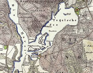
| Map of Lake Tegel from 1842, with Maienwerder in the south | ||
Maienwerder is the southernmost of the seven islands in Tegeler See in Berlin's Reinickendorf district, Tegel district . It is 440 meters long and up to 220 meters wide and has an area of 56,571 m² . It is only 40 meters away from the Kleine Malche , a section of water in the south that is separated from Lake Tegel.
The island is part of the LSG-2C Islands landscape protection area in Tegeler See, which was formed in 1960 . Their use is therefore subject to considerable restrictions and in some cases requires special permits from the nature conservation authority, for example in the case of bank extensions and the construction of jetties.
Individual evidence
- ↑ District Office Reinickendorf von Berlin, Department of Economy and Building, Department of Surveying: Size of the parcels according to the real estate cadastre
- ↑ Tagesspiegel: Valentinswerder: Ripe for the island
- ^ Senate Department for Urban Development, FIS Broker, LSG02c Islands in the Tegeler See.
- ↑ Senate Department for Urban Development, Ordinance on the Protection of the Landscape of the Tegel Forest and the Islands in the Tegeler See in the Reinickendorf and Spandau districts of Berlin, dated October 13, 1960 (PDF; 31 kB)


