
Malchiner See
| Malchiner See | ||
|---|---|---|

|
||
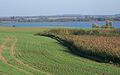
| Malchiner See with Ostberg | ||
| GKZ | DE: 96617 | |
| Geographical location | Mecklenburg Lake District | |
| Tributaries | Westpeene with Mühlenbach, Lupenbach u. a. | |
| Drain | via Dahmer Canal and Peene Canal (Malchiner Peene) into the Kummerower See | |
| Places on the shore | Dahmen , Remplin , Schorssow , Seedorf (to Basedow) | |
| Location close to the shore | Malchin | |
| Data | ||
| Coordinates | 53 ° 41 '39 " N , 12 ° 38' 3" E | |
|
||
| Altitude above sea level | 0.8 m above sea level NHN | |
| surface | 13.95 km² | |
| length | 8.52 km | |
| width | 2.37 km | |
| volume | 35.31 million m³ | |
| scope | 23 km | |
| Maximum depth | 10.0 m | |
| Middle deep | 2.5 m | |
| PH value | 8.6 | |
| Catchment area | 199 km² | |

The Malchiner See is located in a charming cultural landscape southwest of the eponymous city of Malchin in Mecklenburg-Western Pomerania . The districts of Rostock and Mecklenburg Lake District have shares in the approximately eight kilometer long body of water .
Surname
The eponymous town of Malchin is closer to the Kummerower See , but historically Malchiner See and Malchin belonged to Mecklenburg , the Kummerower See and the village of Kummerow to the Duchy and Province of Pomerania . In the Middle Ages it was also called Bülowsee or Wargentiner See.
Location in the water network
The Malchiner See lies in the course of the Western Peene , thus the main hydrographic stream but not the largest or longest source river of the Peene . It rises near Kirch Grubenhagen and flows between the much longer Ziddorfer Mühlbach (made of halalite ) and the only slightly longer Dahmer Mühlbach at the southwest end of the lake near Dahmen .
More inflows are from the perch Moor coming 13.5 km long Lupe Bach (from Sweden Bring, community Peenehagen ) from the south and also water from the lake at Nienhagen approach leading Stammbach 11.27 km in length from Gruber Forst.
The Westpeene leaves the lake at the northeast end at the nature reserve Kalk-Zwischenmoor Wendischhagen . However, its natural course has been largely replaced by the Dahmer Canal since the 19th century . Thanks to its installation, the water level of the lake was lowered by about 2 meters. Today it is on average 0.6 meters above sea level . It is not infrequently only 0.25 m. If the drought continues, it occasionally falls to less than 0.1 m above sea level. NHN. Before the canal was built, Lake Malchin was a cryptodepression . Since then, the water bed is of it to the mouth of the Peenebrücke in the Peenestrom continuously under NHN. Because of a sandback in the lake and low bridges, the canal is only navigable with small boats. After merging with the Ostpeene, the river continues through the (Malchiner) Peene Canal and the preserved lower reaches of the Westpeene into the Kummerower See, from which the Peene flows to the Peene River. A neighboring standing water is the small Haussee (Schorssow) with the Schorssow Castle .
landscape
The ground relief of the lake is irregular. Near the middle of the north-west bank are the deepest spots about ten meters. In the middle of the lake there is a sand threshold, where the lake is only half a meter shallow in places.
The steepest and highest hills (up to 70.5 m above sea level) near the bank rise near Seedorf (zu Basedow ) in the middle of the south-eastern bank. The highest elevations in sight, however, are the Ostberg (115 m above sea level) and a few other crests over 100 m north of the lake.
tourism
In Seedorf (district of Basedow) and Dahmen on the western and southern banks there are campsites, holiday homes, boat docks and small swimming areas. The lake area is characterized by gentle tourism .
Emergence
From a geological point of view, the Malchiner See is located together with the Kummerower See in the approximately 30-kilometer-long Malchiner Basin, a glacial channel that was given its current shape during the Pomeranian stage of the Vistula Ice Age due to melt water below the ice.
The lake is located in the Mecklenburg Switzerland and Kummerower See nature reserve . A section of the Mecklenburg Lake District Ice Age Route runs at its southern end . There are tourist facilities in Dahmen and Seedorf . The Eichberg reaches one kilometer from its east bank 54.5 meters above sea level, the Ostberg four kilometers north of the lake 115.2 meters above sea level.
See also

View from Wendischhagen to the southwest
View from Wendischhagen to the east
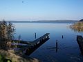
View from Dahmen to the northeast

View from Seedorf to the northwest


Web links
swell
- Topographic map 1: 100,000, sheets C 2338 Güstrow and C 2342 Demmin , Mecklenburg-Western Pomerania state survey office
Individual evidence
- ↑ a b c d e f Brigitte Nixdorf, Mike Hemm, Anja Hoffmann, Peggy Richter: Documentation of the condition and development of the most important lakes in Germany. Part 2: Mecklenburg-Western Pomerania. (PDF; 549 kB) In: Umweltbundesamt.de. January 2004, accessed April 6, 2020 .
- ↑ a b Documentation of the condition and development of the most important lakes in Germany: Foreword (PDF; 471 kB)
- ↑ Georg Christian Friedrich Lisch : "History and documents of the Hahn family", Volume 1, Schwerin, 1844, ( digitized version )
- ↑ Level course Dahmen - Malchiner See - 04718.0. In: pegelportal-mv.de . Retrieved April 19, 2020.
- ↑ a b page no longer available , search in web archives: Geosite database Greifswald: Malchiner See