
Malzer Canal
Two small artificial waterways in the German state of Brandenburg are now known as the Malzer Canal , the official abbreviation MzK . The Malzer Canal started earlier in Liebenwalde , but has risen from Liebenwalde to Friedrichsthal in the Havel-Oder waterway .
history
Malzer Canal (HOW)
The Malzer Canal (HOW), rarely also called Malzer Canal (West), branches off to the west at kilometer 35.55 of the Oder-Havel Canal . It is also one of the predecessor waterways on the Berlin-Stettin major shipping route . The canal starts at 35.54 kilometers from the HOW and continues up to 33.42 kilometers when you reach the Schnellen Havel. The former Malz lock is located at kilometer 35.05 . To overcome the height difference between the former Oder-Havel Canal and the Malzer Canal, a lock was built in Malz in 1824 and a second lock chamber was added around 1874. They formed the southern end of the canalised Havel between the Liebenwalde and Malz locks.
With the completion of the expansion of the Oder-Havel Canal in 1914, the Malz lock was no longer required for freight traffic. The older lock was closed in 1930 and converted into a weir. In 1968 it was renewed. The lock from 1874 was also converted into a weir in 1975. Ships and boats cannot pass the canal step; today they only serve to regulate the water level. The Malzer Canal (HOW) is legally part of the Havel-Oder-Wasserstraße . Two bridges cross the canal, the Schleusenbrücke and the Freiarchenbrücke Malz. You cross the district road K 6507 over the Malzer Canal. The Freiarchenbrücke was built in 1828 in connection with the construction of the Malz lock. It was blown up in 1945 and then rebuilt. The lock bridge was built in 1857 and was last repaired in 1978. In the period from October 2000 to April 2002, a new replacement was built for the lock bridge and the Freiarchen bridge. The lock bridge leads over the lower heads of the former two-chamber lock. The Malz shipyard is located in the upper water of the lock on the south bank between the Oder-Havel Canal and the disused lock. The water is navigable from the main waterway to the shipyard.
Coordinates of the Malz lock in the Malzer Canal (HOW)
52 ° 47 '52 " N , 13 ° 17' 31" E
photos
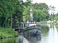
Today's situation, Malzer Canal junction, the shipyard on the left, the former locks in the background
Malz locks (built in 1828 and 1857) on the Malzer Canal

Remnants of the original Malzer Canal

Below the former lock

Malzer Canal (HOW) and Malz lock on the map above
.JPG)


Malzer Canal (OHW)
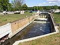
The part of the Upper Havel waterway that branches off at kilometer 40.50 from the Havel-Oder waterway to the north to the Voss Canal is called Malzer Canal, rarely Malzer Canal (east), official abbreviation MzK. (km 43.95 to 46.90). It belongs legally to the Upper Havel waterway and is almost three kilometers long. The Liebenwalde lock is at km 45.30 . At the Finow Canal from the east (km 46.90) the Voss Canal (sometimes also the Voss Canal) begins to the north at km 0.00. The Malzer Canal (OHW) is a class IV federal waterway.
Coordinates of the Liebenwalde lock in the Malzer Canal (OHW)
52 ° 51 '2 " N , 13 ° 23' 46" E
photos

Old Liebenwalde lock from 1834

literature
- H.-J. Uhlemann: Berlin and the Märkische waterways. DSV-Verlag, Hamburg 1994, p. 167 ff. ISBN 3-344-00115-9 .
- Writings of the Association for European Inland Shipping and Waterways e. V. WESKA (Western European Shipping and Harbor Calendar), Binnenschifffahrts-Verlag, Duisburg-Ruhrort. OCLC 48960431
cards
- Folke Stender: Editing of Sportschifffahrtskarten Binnen 1 + 4. Nautical publication Verlagsgesellschaft, ISBN 3-926376-10-4 .
- W. Ciesla, H. Czesienski, W. Schlomm, K. Senzel, D. Weidner: Shipping maps of the inland waterways of the German Democratic Republic 1: 10,000. Volume 4. Editor: Waterways Authority of the GDR, Berlin 1988, OCLC 830889996 . Page 113 ff.
Web links
- Chronicle of the legal status of the federal imperial waterways / inland waterways in the territory of the Federal Republic of Germany after October 3, 1990 (PDF file) Directory D numbers 21 and 39, accessed on February 22, 2016