Mambéré
| Mambéré | ||
|
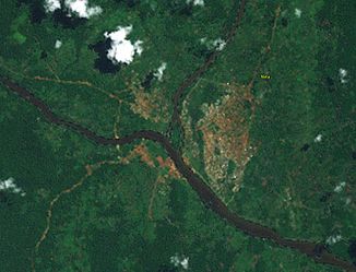
The northern catchment area of the Sangha with the Mambéré (top right) |
||
| Data | ||
| location |
|
|
| River system | Congo | |
| Drain over | Sangha → Congo → Atlantic | |
| source | 50 km southeast of Meiganga 6 ° 14 ′ 0 ″ N , 14 ° 44 ′ 0 ″ E |
|
| Source height | 1143 m | |
| muzzle | Confluence with the Kadéï coordinates: 3 ° 30 '55 " N , 16 ° 2' 50" E 3 ° 30 '55 " N , 16 ° 2' 50" E |
|
| Mouth height | 379 m | |
| Height difference | 764 m | |
| Bottom slope | 1.9 ‰ | |
| length | 400 km | |
| Catchment area | 27,900 km² | |
| Discharge at the Nola A Eo gauge : 27,900 km² at the mouth |
MQ Mq |
280 m³ / s 10 l / (s km²) |
| Left tributaries | Yoyo , Nana | |
| Right tributaries | Limba | |
| Medium-sized cities | Carnot , Nola | |
|
Confluence of the Mambéré (right) with the Kadéï (left) |
||
The Mambéré is a river in the Central African Republic .
course
It rises about 50 km southeast of the city of Meiganga , directly on the border with Cameroon in the prefecture Nana-Mambéré on the edge of the Adamaua highlands . From there it flows in a south-easterly direction. In its upper reaches it has only a slight gradient. At Carnot it takes up the Nana , its most important tributary. About 80 km below Carnot it changes course and flows directly south until it joins the Kadéï at Nola and thereby forms the Sangha .
raw materials
The Mambéré is a notable deposit for diamonds.

