Mandali
| Mandali | ||
|---|---|---|
| location | ||
|
|
||
| Coordinates | 33 ° 45 ′ N , 45 ° 33 ′ E | |
| Country |
|
|
| Governorate | Diyala | |
| Basic data | ||
| height | 125 m | |
| Residents | 5,800 | |
| Location of Mandali | ||
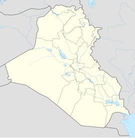
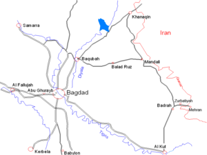
Mandali ( Arabic مندلي, Kurdish Mendelî ) is an Iraqi city in the Diyala province , close to the Iranian border. The population is an estimated 5,800 people.
The city is located about 120 km northeast of Baghdad between Chanaqin and Badrah.
history
During the systematic Arabization policy of the Iraqi regime, many Kurds were expelled and Arabs settled in the city. The Kurds have been resettled to the south of Iraq or have fled to the Kurdish-controlled north .
The city gained military-historical importance during the First Gulf War when Iranian troops tried to break through the Iraqi front line at Mandali in April 1983 and thus free the way to Baghdad. Despite the so-called tactics of human waves , where thousands of poorly-armed Iranian soldiers zustürmten without cover on the front, failed Iranian offensive on the fierce resistance of the better-equipped Iraqi army , the artillery and Luftwaffe began. Around 100,000 Iranians and 50,000 Iraqis are said to have lost their lives in the fighting over Mandali alone. The Mandali offensive was one of the last major breakthrough attempts in the First Gulf War: After the failure of the Iranian plans, the front stabilized and changed little until the ceasefire in 1988.
Web links
- Mandali . globalsecurity.org (English)
- German translation and pictures from Mandali 1975
- Military historical overview of the First Gulf War (English)

