Mangfall Valley
|
Mangfall Valley
|
||
|
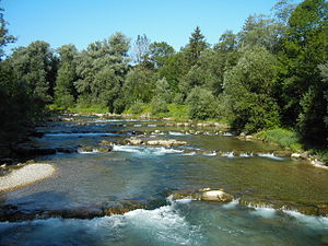
The Mangfall Bend at Valley (upstream) |
||
| location | Miesbach , Rosenheim | |
| WDPA ID | 555522144 | |
| Natura 2000 ID | 8136-371 | |
| FFH area | 13.48 km² | |
| Geographical location | 47 ° 50 ' N , 11 ° 47' E | |
|
|
||
| Setup date | 2004 | |
| administration | Bavarian State Ministry for Agriculture and Forests | |
Mangfalltal describes the landscape shaped by the Mangfall river in Upper Bavaria , in particular the settlement, cultural and economic area there. It extends over a length of about 50 kilometers along the Mangfall from Gmund am Tegernsee in the Miesbach district to Rosenheim , where the Mangfall flows into the Inn .
history
The formation of the Mangfall Valley in its current form can be traced back to the Inn Glacier .
The Mangfalltal is a historical cultural area that formed an independent unit as Sundergau in the Bavarian era . In the Middle Ages it was ruled by the Falkensteiners for a long time , before it was built at the end of the 13th century after the murder of Count Sigebothus VI. fell to the Wittelsbach family . They had the region administered from Aibling , where there was already a bailiwick of the Bamberg diocese and the Neuburg-Falkensteiner.
topography
Topographically, a distinction is made between the upper and lower Mangfall valley. The "Upper Mangfall Valley" stretches from the Mangfallknie at Valley upstream to the Tegernsee , the outlet of which is the Mangfall. In this part of Weyarn the Mangfall Bridge of the Federal Highway 8 crosses the deeply cut valley. The "Lower Mangfall Valley" stretches from Feldkirchen-Westerham downstream to Rosenheim , where the Mangfall flows into the Inn .
When one speaks of the Mangfall Valley, the "Lower Mangfall Valley" with the cities and communities Feldkirchen-Westerham , Bruckmühl , Bad Aibling , Kolbermoor and Rosenheim is often meant, which is probably due to the fact that this area was already a settlement area in prehistoric times and is still a contiguous one today Represents the economic area in Upper Bavaria .
Infrastructure
In the upper Mangfall valley, most of the drinking water for the state capital Munich is obtained. From 1881, sources in this area were developed and expanded over the years. Today the water from the Mangfall Valley covers around 80 percent of Munich's drinking water needs.
The Stadtwerke München as operator of water production in Mangfalltal promotes since 1992 there the organic farming to the high quality to secure the water.
Cultural
Numerous clubs, associations, cultural and public institutions have Mangfalltal in their name.
Protected areas
The Mangfall flows through several landscape protection areas:
- Protection of the Tegernsee and the surrounding area (LSG-00072.01) in Gmund am Tegernsee up to about 1 km after the outflow from the Tegernsee
- Protection of the Egarten landscape around Miesbach (LSG-00550.01) from Gmund am Tegernsee to the northern city limits of Miesbach
- Protection of the green areas on the Mangfall (LSG-00322.01) in the area of the city of Rosenheim up to the confluence with the Inn
From Gmund am Tegernsee to Unterreit , the Mangfall valley is designated as a flora-fauna-habitat area worthy of protection in the Miesbach district and in the Rosenheim district . After the Bavarian Natura 2000 Ordinance came into force on April 1, 2016 , which regulates the guidelines for fauna-flora-habitat areas (FFH areas) and the European bird sanctuaries, a management plan was started for the Mangfall Valley. In a planning period of around two years, the first step will be to record, document and map the existing population and, in the following steps, determine the necessary conservation measures for the protected area. The executing authorities are the Office for Food, Agriculture and Forests in Holzkirchen and Ebersberg.
literature
- K. Schönmetzler, K. Schubert, K. Förg: Mangfalltal - Bad Aibling and its landscape , Edition Förg, ISBN 3-9803116-2-7 .
- The Mangfallgau, local history yearbook for the Bad Aibling district, published by the Historical Association for Bad Aibling and the surrounding area, has been published irregularly since 1956.
Web links
Individual evidence
- ↑ The Bavarian Natura 2000 regulation came into force on April 1, 2016. Bavarian State Ministry for the Environment and Consumer Protection, accessed on May 15, 2016 .
- ↑ Christine Merk: A living space that is particularly worthy of protection. Münchener Zeitungs-Verlag GmbH & Co.KG, May 12, 2016, accessed on May 16, 2016 .
- ^ Office for Food, Agriculture and Forests Holzkirchen - Natura 2000. Accessed on May 15, 2016 .
- ^ Office for Food, Agriculture and Forests Ebersberg - Natura 2000. Accessed on May 15, 2016 .

