
Manicouagan Reservoir
| Manicouagan Reservoir Manicouagan Reservoir |
|||||||||
|---|---|---|---|---|---|---|---|---|---|
 |
|||||||||
|
|||||||||
|
|||||||||
| Coordinates | 51 ° 7 '55 " N , 68 ° 41' 10" W | ||||||||
| Data on the structure | |||||||||
| Lock type: | Pier dam , arch dam | ||||||||
| Construction time: | 1962-1968 | ||||||||
| Height above foundation level : | 214 m | ||||||||
| Building volume: | 2 255 000 m³ | ||||||||
| Crown length: | 1 314 m | ||||||||
| Crown width: | 3 m | ||||||||
| Base width: | 22.5 m | ||||||||
| Power plant output: | Manic-5: 1596 MW Manic-5-PA: 1064 MW |
||||||||
| Operator: | Hydro Quebec | ||||||||
| Data on the reservoir | |||||||||
| Altitude (at congestion destination ) | Max. 359.6 m | ||||||||
| Water surface | 1950 km² | ||||||||
| Storage space | 141.6 km³ | ||||||||
| Catchment area | 29,241 km³ | ||||||||
 |
|||||||||

The Manicouagan Reservoir ( French Réservoir Manicouagan , also called Lac Manicouagan ) is a ring-shaped lake within an impact crater in the Côte-Nord region of the Canadian province of Québec .
The dammed lake surrounds the roughly circular René Levasseur Island as a ring with a diameter of around 70 km and shows the structures created by an impact in the natural elevation profile. The dam, which was completed in 1968 to the south of the ring structure in the Manicouagan River valley, is located around 500 km north-northeast of Québec and around 200 km north of Baie-Comeau . The area of the Réservoir Manicouagan is up to 1950 km² , depending on the level of the dam , its volume up to 141.6 km³ ; the catchment area covers 29,241 km². Tributaries include the Rivière Mouchalagane , Rivière Thémines , Rivière Seignelay and Rivière Hart Jaune . The outflow is the Rivière Manicouagan , which flows south and flows into the Saint Lawrence River at Baie-Comeau .
crater
The circular lake formed within the ring structure of a complex impact crater . This was formed about 214 million years ago in the Upper Triassic by the impact of an asteroid with a diameter of at least five kilometers.

The impact is not, as previously assumed, responsible for the mass extinction at the Triassic-Jurassic border , as this occurred about 13 million years earlier. The impact of the cosmic object created a crater about 100 kilometers in diameter. Thus, the Manicouagan event , together with the Chicxulub impact in what is now Mexico and the Siberian Popigai impact , is one of the three largest asteroid impacts during the Phanerozoic .
Due to sedimentation and erosion , the original diameter of the Manicouagan crater has now been reduced to 72 kilometers. In the middle of the ring-shaped lake is the 2020 km² René Levasseur Island . Its highest point, the summit of the 952 meter high Mont Babel , a central mountain created by isostasy , is about 600 meters above the water level of the reservoir.

Light impactite rock, a suevite , from the impact crater
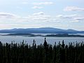
View over the reservoir, in the background Mont Babel , the central mountain


Reservoir
The lake area of Manicouagan and Mouchalagan was converted into a reservoir in the 1960s by building a dam about 60 km south of the ring of the impact structure in order to generate electrical energy from hydropower . About a third of that contained in the previously natural waters is dammed as an additional amount of water. In the reservoir target pursued since the 1980s, the water surface is around 350 meters above sea level and is 1788 km², the volume of the lake 137.9 km³, of which 35.2 km³ is available for the generation of electrical energy by turbines.
With a maximum storage height of 359.6 meters above sea level, the lake is around 1950 km² and has a volume of 141.6 km³ (141.6 trillion liters ). The reservoir is up to 350 meters deep, an average of around 85 meters. The dam is one of the ten largest in the world, measured in terms of storage space.
Power plants
The Daniel-Johnson-Barrage (Barrage Daniel-Johnson) is 1314 meters long and with a height of 214 meters the world's highest pier dam . It is located south in the valley of the Manicouagan River ( 50 ° 38 ′ 49 ″ N , 68 ° 43 ′ 27 ″ W ). Their exact design is that of a multiple arch dam .
There are two hydropower plants with a total output of 2660 megawatts on the dam wall : The Manic-5 hydropower plant ( 50 ° 38 ′ 23 ″ N , 68 ° 43 ′ 37 ″ W ) with eight turbines and an output of 1596 megawatts (built in 1970) and the neighboring hydropower plant Manic-5-PA ( 50 ° 38 ′ 26 ″ N , 68 ° 44 ′ 13 ″ W ) with four turbines and an output of 1064 megawatts (built in 1989).
See also
Web links
- Manicouagan Reservoir
- Manicouagan Impact Crater on Earth - Astronomy Picture of the Day of December 13, 2000 (English).
Individual evidence
- ↑ a b c d Manicouagan Reservoir on World Lake Database, accessed March 30, 2019.
- ↑ Pessamit exige la fin du rehaussement du réservoir Manicouagan in the Journal Haute-Côte-Nord of 7 July 2017; accessed on March 30, 2019.
- ↑ according to information from the operator Hydro-Quebec's Réservoirs , accessed on March 30, 2019.