
Matale
| Matale | |||
|---|---|---|---|
|
|||
| Coordinates | 7 ° 28 ′ N , 80 ° 37 ′ E | ||
| Basic data | |||
| Country | Sri Lanka | ||
| Central Province | |||
| District | Matale | ||
| ISO 3166-2 | LK-22 | ||
| height | 470 m | ||
| Residents | 37,000 | ||

Matale is a city in the central province of Sri Lanka , it lies at around 470 m above sea level and has a population of around 37,000.
The city is the center of an important plantation area in which rubber, cinnamon, pepper, chilies, tea, rice and vegetables are grown. The flourishing of these numerous crops is caused by the humid tropical climate and the location in a mountain basin that is only interrupted in the north.
Attractions
The city is dominated by the British Fort Macdowall , which was built in the early 19th century as part of the British war of conquest against the Kingdom of Kandy . It is located above the central Saxton Park, near which is the commercial and administrative center of the city of Matale.
In the center is also the Hindu temple Sri Muthumariamman Thevasthaman , whose colorful, rich figure decorations are extremely interesting.
Furthermore, the rock temple of Aluvihara , which is one of the most important sites of Buddhism in Sri Lanka, is located in the Matale area .
Personalities
- Bede Beckmeyer (1873–1935), Roman Catholic religious and bishop of Kandy
photos
- Matale
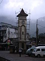
clock tower
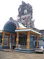
Hindu temple
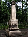
Memorial to the uprising of 1848

Cityscape


