
Mattervispa
| Mattervispa | ||
 Mattervispa |
||
| Data | ||
| Water code | CH : 182 | |
| location | District of Visp , Canton of Valais , Switzerland | |
| River system | Rhone | |
| Drain over | Vispa → Rhone → Mediterranean | |
| origin | Confluence of the Zmuttbach and Gornera 46 ° 0 ′ 40 ″ N , 7 ° 44 ′ 22 ″ E |
|
| Source height | 1624 m above sea level M. | |
| muzzle | Confluence in Stalden with the Saaservispa Coordinates: 46 ° 13 ′ 51 ″ N , 7 ° 52 ′ 20 ″ E ; CH1903: 633 447 / 120022 46 ° 13 '51 " N , 7 ° 52' 20" O |
|
| Mouth height | 723.5 m above sea level M. | |
| Height difference | 900.5 m | |
| Bottom slope | 30 ‰ | |
| length | 30 km | |
| Catchment area | 487.32 km² | |
| Discharge A Eo : 487.32 km² at the mouth |
MQ Mq |
13.96 m³ / s 28.6 l / (s km²) |
| Left tributaries | Schalibach, Bisbach, Tummigbach, Blattbach, Jungbach , Embdbach | |
| Right tributaries | Findelbach , Täschbach, Riedbach | |
| Reservoirs flowed through | Compensation lake Mattsand | |
| Communities | Zermatt , Täsch , Randa , St. Niklaus , Grächen , Embd , Törbel , Stalden | |
The Mattervispa is a river in the Mattertal in the canton of Valais . At Stalden it unites with the Saaservispa to form Vispa .
geography
The river is created by the confluence of the Zmuttbach and Gornera south of Zermatt . From there it flows through the village towards Täsch . Here the Täschbach flows into the Mattervispa. The water continues to Randa and St. Niklaus , at the last-mentioned place the Jungbach is added. At Stalden, the Mattervispa merges with the Saaservispa and forms the Vispa.
Below Randa, the river was buried in 1991 by the Randa landslide . Since then, the river has been flowing around the scree cone, which is still clearly visible today.
photos

The Mattervispa in Zermatt.

Mattervispa between Zermatt and Täsch (in the background).
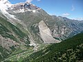
The Mattervispa below Randa with the landslide of 1991


Web links
Individual evidence
- ↑ a b c Geoserver of the Swiss Federal Administration ( information )
- ↑ a b Topographical catchment areas of Swiss waters: sub-catchment areas 2 km². Retrieved June 9, 2019 .