Messini
|
Messini municipality Δήμος Μεσσήνης |
||
|---|---|---|
|
|
||
| Basic data | ||
| State : |
|
|
| Region : | Peloponnese | |
| Regional District : | Messinia | |
| Geographic coordinates : | 37 ° 3 ' N , 22 ° 0' E | |
| Area : | 565.58 km² | |
| Residents : | 23,482 (2011) | |
| Population density : | 41.5 inhabitants / km² | |
| Seat: | Messini | |
| LAU-1 code no .: | 4403 | |
| Districts : | 8 municipal districts | |
| Local self-government : |
1 city district 69 local communities |
|
| Website: | www.emessinia.gr | |
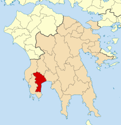
| Location in the Peloponnese region | ||
Messini ( Greek Μεσσήνη ( f. Sg. )) Is a municipality in the center of Messenia in Greece . The administrative center is in the small town of the same name, which used to be the capital of the Messinis province, which was dissolved in 1999. The ancient predecessor of the city, Messene, was about 15 to 20 km further north near the village of Mavromati ( Ithomi municipality ).
Today, Messini has largely transferred its role as the central location to the city of Kalamata , which is in the immediate vicinity further east and is separated by the Kalamata airport in between and the village of Asprochoma, which belongs to the municipality of Kalamata.
Community structure
The municipality of Messini, which existed from 1997 to 2010 and from 2011 onwards, has 11,041 inhabitants on 84.6 km². In the structure created by the administrative reform in 2010 and valid from 2011, the new municipality of Messini is divided as follows:
- Androusa municipality
- Aristomenis municipality
- Epia parish
- Ithomi parish
- Messini municipality
- Petalidi municipality
- Trikorfo parish
- Voufrades municipality
sons and daughters of the town
- Michail Stasinopoulos (1903–2002), President of Greece
- Pol D. Spanos (born 1950), engineer
- Vasilis Leventis (* 1951), politician
- Louis Tsatoumas (* 1982), long jumper
Individual evidence
- ↑ Results of the 2011 census at the National Statistical Service of Greece (ΕΛ.ΣΤΑΤ) ( Memento from June 27, 2015 in the Internet Archive ) (Excel document, 2.6 MB)


