Miranda do Douro
| Miranda do Douro | ||||||
|---|---|---|---|---|---|---|
|
||||||
| Basic data | ||||||
| Region : | Norte | |||||
| Sub-region : | Terras de Trás-os-Montes | |||||
| District : | Bragança | |||||
| Concelho : | Miranda do Douro | |||||
| Coordinates : | 41 ° 30 ′ N , 6 ° 16 ′ W | |||||
| Residents: | 2254 (as of June 30, 2011) | |||||
| Surface: | 35.52 km² (as of January 1, 2010) | |||||
| Population density : | 63 inhabitants per km² | |||||
| Postal code : | 5210 | |||||
| politics | ||||||
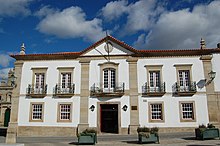
| Address of the municipal administration: | Junta de Freguesia de Miranda do Douro Av. Aranda de Duero 5210-217 Miranda do Douro |
|||||
| Website: | mirandadodouro.jfreguesia.com | |||||
| Miranda do Douro county | ||||||
|
||||||
| Residents: | 7482 (as of June 30, 2011) | |||||
| Surface: | 487.18 km² (as of January 1, 2010) | |||||
| Population density : | 15 inhabitants per km² | |||||
| Number of municipalities : | 13 | |||||
| administration | ||||||
| Administration address: | Câmara Municipal de Miranda do Douro Largo D. João III 5210-190 Miranda do Douro |
|||||
| President of the Câmara Municipal: | Dr Artur Manuel Rodrigues Nunes ( PS ) | |||||
| Website: | www.cm-mdouro.pt | |||||
Miranda do Douro ( Mirandés Miranda de l Douro ) is a municipality and city in the Bragança district in northeast Portugal . The city lies above the Douro River , which forms the border between Spain and Portugal here.
history
Finds of ramparts prove a prehistoric settlement at least since the Castro culture . The place was probably taken from the Moors in the course of the beginning Reconquista in 857 and received its first town charter ( Foral ) in 1136 by the later King of Portugal, D.Afonso Henriques , who expanded Miranda into a military base. In 1217 the place received its first Portuguese city rights from King Alfonso II , who confirmed the Foral of 1136.
King D Dinis had a castle built here in 1286 and gave it the status that the castle of Algoso had previously had . From 1294, the development of the place Miranda do Douro began to become a city, which from then on was directly subordinate to the crown. This was in connection with the negotiations on the definitive demarcation of the border, which was stipulated in the Treaty of Alcañices in 1297 : on September 7, 1297, D. Dinis gave the border town of Miranda do Douro new city rights, elevated it to vila , and placed it directly under the crown, and on September 12th the treaty between the Kingdom of Portugal and the Kingdom of Castile was concluded.
After Miranda do Douro had received the status of a small town ( Vila ) in 1320 , King D. João III raised. the place in 1545 to the city ( Cidade ). On July 10, 1545, work began on building the cathedral to make Miranda do Douro a bishopric according to the papal bull of May 22 of the same year.
In 1680 the bishopric was moved to Bragança . In the course of the Seven Years War , the place suffered some destruction in 1762, including the castle towers, and around 400 residents of the place died. The damaged castle was subsequently left to decay.
With the construction of the Picote and Miranda dams, which began in 1954 , the district town experienced a relative boom and became a trading town, where visitors from neighboring Spain bought textiles, shoes, watches and jewelry in particular.
Culture and sights
The only regional language of Portugal, Mirandés, survives in villages outside Miranda . It is recognized as its own language and is encouraged. The street signs in the places where Mirandés is spoken, for example, are bilingual. A number of customs and traditions of Celtic origin have also been preserved here, such as the stick dance, which goes back to a Celtic sword dance and which is performed by three musicians and eight dancers in traditional costumes , the Pauliteiros de Miranda . Like Mirandés and a multitude of legends, the stick dance, contrary to its name, has its home not in Miranda itself, but in the surrounding villages. This fact can be seen, for example, in the Festival Intercéltico de Sendim , which has been held in the municipality of Sendim since 2000 .
In addition to excavations of the Castro culture , the ruins of the castle ( Castelo ) can also be seen, as well as the aqueduct with fountains built in 1545 , various historical public buildings and sacred buildings , including the Mannerist church Igreja da Misericórdia de Miranda do Douro , which was built from 1578 onwards . a. baroque altars made of gilded wood carving ( Talha dourada ).
Miranda do Douro belongs to the Parque Natural do Douro Internacional , a natural park along the border-defining section of the Douro. Miranda sits at the breakthrough of the river through a high rock massif, on which the place is located and from where you have a rewarding view of the low-lying, impetuous river breakthrough and the shimmering cliffs of different colors. Then begins the historic town center with its pedestrianized cobbled streets, which are characterized by houses decorated with coats of arms from the 15th and 16th centuries. One of those houses is the Museu da Terra de Miranda, the local museum, which is also dedicated to Mirandés . The town center is a listed building as a whole.
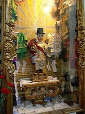
The three-aisled cathedral stands next to the ruins of the old bishopric, which is now surrounded by a small park. The baby Jesus with the top hat ( Portuguese : Menino Jesus da Cartolinha) is exhibited in it and carried along in processions. The figure, equipped with various historical clothing sets, goes back to two parallel legends, according to which Jesus appeared as a boy dressed in this way and rekindled the declining defensive will of the population who persevered against a Spanish siege in the War of Restoration and made victory possible. The second legend tells of a local nobleman who died in those defensive battles. In order to keep the memory of her promised bridegroom alive, the bride-to-be promised to donate a figure of Jesus to the place, with clothes like those of her bridegroom, which he intended to wear after the wedding.
administration

Miranda do Douro county
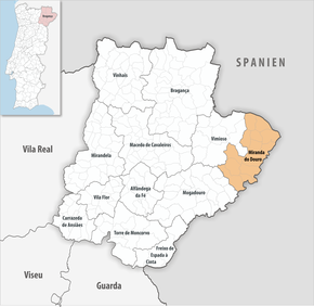
Miranda do Douro is the seat of a district of the same name with 7482 inhabitants (as of June 30, 2011), which borders Spain in the north and east . The neighboring districts are Mogadouro and Vimioso .
With the regional reform in September 2013, several municipalities were merged into new municipalities, so that the number of municipalities decreased from 17 to 13.
The following municipalities ( freguesias ) are in the Miranda do Douro district (the name in Mirandés in brackets):
| local community | Population (2011) |
Area km² |
Density of population / km² |
LAU code |
|---|---|---|---|---|
| Constantim e Cicouro | 204 | 36.33 | 6th | 040618 |
| Duas Igrejas | 599 | 49.90 | 12 | 040604 |
| Genísio | 186 | 29.47 | 6th | 040605 |
| Ifanes e Paradela | 311 | 44.70 | 7th | 040619 |
| Malhadas | 344 | 27.67 | 12 | 040607 |
| Miranda do Douro | 2,254 | 35.52 | 63 | 040608 |
| Palaçoulo | 554 | 42.37 | 13 | 040609 |
| Picote | 301 | 19.43 | 15th | 040611 |
| Póvoa | 208 | 22.54 | 9 | 040612 |
| Sao Martinho de Angueira | 307 | 36.77 | 8th | 040613 |
| Sendim e Atenor | 1,487 | 58.93 | 25th | 040620 |
| Silva e Águas Vivas | 400 | 40.61 | 10 | 040621 |
| Vila Chã de Braciosa | 327 | 42.94 | 8th | 040616 |
| Miranda do Douro county | 7,482 | 487.18 | 15th | 0406 |
Population development in the district
| Population in Miranda do Douro County (1801–2011) | |||||||||
|---|---|---|---|---|---|---|---|---|---|
| 1801 | 1849 | 1900 | 1930 | 1960 | 1981 | 1991 | 2001 | 2004 | 2011 |
| 7706 | 7146 | 10,639 | 11,272 | 18,972 | 9948 | 8697 | 8048 | 7707 | 7482 |
Town twinning
sons and daughters of the town
- Abílio Augusto Vaz das Neves (1894–1974), Bishop of Bragança
- Rui Pereira (* 1956), politician ( PS )
- Leonel Vieira (* 1969), film producer and director
literature
- Miranda do Douro . In: Isabel Silva (ed.): Dicionário Enciclopédico das Freguesias . 2nd Edition. tape 3 : Bragança, Guarda, Vila Real . Minha Terra, Matosinhos 1997, ISBN 972-96087-7-6 , pp. 94 (Portuguese).
Web links
- Map of the Freguesia Miranda do Douro at the Instituto Geográfico do Exército
Individual evidence
- ↑ www.ine.pt - indicator resident population by place of residence and sex; Decennial in the database of the Instituto Nacional de Estatística
- ↑ a b Overview of code assignments from Freguesias on epp.eurostat.ec.europa.eu
- ↑ a b www.ine.pt - indicator resident population by place of residence and sex; Decennial in the database of the Instituto Nacional de Estatística
- ↑ monumentos.pt (under Cronologia ), accessed on February 10, 2013.
- ↑ monumentos.pt (under Cronologia ), accessed on February 10, 2013.
- ↑ verportugal.net , accessed on February 10, 2013.
- ↑ cm-mdouro.pt ( Memento of the original from March 30, 2012 in the Internet Archive ) Info: The archive link was inserted automatically and has not yet been checked. Please check the original and archive link according to the instructions and then remove this notice. , accessed February 10, 2013.
- ↑ monumentos.pt , accessed on February 10, 2013.
- ↑ monumentos.pt
- ^ Lydia Hohenberger, Jürgen Strohmaier: Portugal. 2nd edition, DuMont Reiseverlag, Ostfildern 2009, p. 306 f.
- ↑ monumentos.pt , accessed on February 10, 2013.
- ↑ cm-mdouro.pt ( memento from June 23, 2009 in the Internet Archive ), accessed on February 10, 2013.
- ↑ Publication of the administrative reorganization (PDF) in the Diário da República law gazette of January 28, 2013, accessed on March 16, 2014.
- ↑ anmp.pt , accessed on February 10, 2013.


