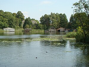
Mirower See
| Mirower See | ||
|---|---|---|

|
||
| Geographical location | Mecklenburg Lake District , Germany | |
| Tributaries | Granzower Möschen and Kleiner Schulzensee | |
| Drain | Canal to the Müritz-Havel waterway | |
| Places on the shore | Mirow | |
| Data | ||
| Coordinates | 53 ° 16'53 " N , 12 ° 48'26" E | |
|
|
||
| Altitude above sea level | 58.6 m above sea level NHN | |
| surface | 1.02 km² | |
| Maximum depth | 7 meters | |
The Mirower See is a lake in the Mecklenburg Lake District in the Mecklenburg Lake District . It is one of the so-called other inland waterways of the federal government and is the responsibility of the Eberswalde Waterways and Shipping Office .
geography
location
The Mirower See is located about eleven kilometers southeast of the southeast bank of the Müritz and extends north-west of Mirow immediately to the north. The lake, which is bordered by forests in the north, fields and meadows in the central part and Mirow on the south-east bank, is almost 2.5 kilometers long, up to 700 meters wide and a maximum of seven meters deep. Its altitude is 58.6 m above sea level. NHN . In the north of the lake there is a hook-shaped bay about one kilometer long, facing west. The Kleine Schulzensee flows into this from the south.
Islands
There is an island and an island within the Mirower See.
Mirow Castle, a Baroque castle built between 1748 and 1752 as the summer residence of the Mecklenburg dukes , and the Johanniterkirche , whose tower can be climbed , are located on the Mirow Castle Island , which is directly in front of Mirow .
The island of love, which is a small island immediately north of the castle island, can be reached via an old, restored bridge that leads over the narrow arm of the water between the two small islands. On this island is the tomb of the last Grand Duke of Mecklenburg-Strelitz , Adolf Friedrich VI. (1882–1918) who took his own life. His not completely decomposed body is laid out in the tomb.
Waterways
A narrow canal, only about 200 meters long, connects the Mirower See with the Müritz-Havel-Wasserstraße (MHW) at km 22.52. At the confluence of this canal, only a few hundred meters from the south bank of the Mirower See, the Mirower Canal , the northwestern part of the MHW, joins ; it branches off from the Kleine Müritz of the Müritz-Elde waterway and runs through Sumpfsee and Ragunsee to Mirow. Since 1936, the Mirower Canal has replaced the Alte Fahrt or Alte Müritz-Havel-Wasserstraße, which flows into the Mirower See from the north. Until then it was the usual shipping route between the Havel and Müritz.
The old MHW begins with the Bolter Canal , which had a lock in the area of the Bolter Mühle , which, however, was filled in, on the east bank of the Müritz . Next close Caarpsee , Woterfitzsee , Leppinsee , the two Kotzower lakes and Granzower Möschen on.
Together with the Mirower See, these lakes form a chain of lakes, which is used by paddlers as a branch route on the way from the Müritz. From the Mirower to the Leppinsee, ships with internal combustion engines are also allowed to travel. However, Woterfitzsee and Caarpsee are closed to vehicles with internal combustion engines.
literature
- Martin Eckoldt (Hrsg.): Rivers and canals: The history of the German waterways . DSV-Verlag, Hamburg 1998; Busse-Seewald, Herford, ISBN 3-88412-243-6
Web links
Individual evidence
- ↑ Directory F of the Chronicle ( Memento of the original from July 22, 2016 in the Internet Archive ) Info: The archive link was automatically inserted and not yet checked. Please check the original and archive link according to the instructions and then remove this notice. , Federal Waterways and Shipping Administration
- ↑ a b Lengths (in km) of the main shipping lanes (main routes and certain secondary routes) of the federal inland waterways ( Memento of the original from January 21, 2016 in the Internet Archive ) Info: The archive link was automatically inserted and not yet checked. Please check the original and archive link according to the instructions and then remove this notice. , Federal Waterways and Shipping Administration
