Montmédy
| Montmédy | ||
|---|---|---|

|
|
|
| region | Grand Est | |
| Department | Meuse | |
| Arrondissement | Verdun | |
| Canton | Montmédy (main town) | |
| Community association | Pays de Montmédy | |
| Coordinates | 49 ° 31 ' N , 5 ° 22' E | |
| height | 177–336 m | |
| surface | 23.49 km 2 | |
| Residents | 2,136 (January 1, 2017) | |
| Population density | 91 inhabitants / km 2 | |
| Post Code | 55600 | |
| INSEE code | 55351 | |
| Website | http://www.montmedy.fr/ | |
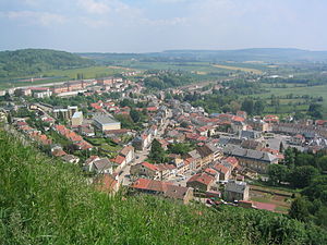
 View of Montmédy |
||
Montmédy is a French commune with 2,136 inhabitants (as of January 1, 2017) in the Meuse department in the Grand Est region (until 2015 Lorraine ). It belongs to the arrondissement of Verdun and is the capital of the canton of Montmédy .
geography
The small town is located on the Chiers River , six kilometers from the Belgian border.
history
The city was the center of County Chiny from 941 to 1364 . Subsequently it belonged to the Duchy of Luxembourg until 1657 . 1221 was by Count Arnold III. Chiny built the first castle in Montmédy. In the 16th century , the castle was replaced by a fortress under the rule of Emperor Charles V.
In June 1791, King Louis XVI tried . of France to escape from Paris with his family to escape captivity in the Tuileries . In the border town of Montmédy, as close as possible to the strongholds of the Rhineland emigrants , he wanted to establish contact with his brother Count von Artois and the party of the Ancien Régime without having to leave France. The so-called escape to Varennes , of course, never reached Montmédy.
citadel
After Marville and Stenay had been occupied by the French in 1657 , the citadel of Montmédy was besieged by 30,000 soldiers under the leadership of King Louis XIV , Jules Mazarin and Sébastien Le Prestre de Vauban in the same year . 756 men defended it for 57 days and only surrendered after the death of Governor Jean V of Allamont . After the siege was over, Vauban improved the outer fortifications, the moats and the ramparts. The citadel is located on a hill west of the town center. There is only one approach to the citadel from the north.
During the Franco-Prussian War , Montmédy was besieged as an important railway point by the Prussian 14th Division under General von Kameke from December 7th to 14th, 1870 and forced to surrender by short but violent shelling. The citadel was also used in both world wars.
The Crown Prince received from a detachment of all storm-companies and the band existing guard of honor of the storm battalion no. 5 (tube) on 7 September 1916, the station the first time during the First World War French soil boarding the Field Marshal v. Hindenburg and General Ludendorff .
Inside the citadel there are houses and a church. Some of the houses were built in the 17th century. However, most of the houses have fallen into disrepair or have already collapsed, while others are still used as residential homes. A tourist office is also located in the citadel. The citadel is now considered to be one of the most important military structures in northeastern France.
Population development
| year | 1962 | 1968 | 1975 | 1982 | 1990 | 1999 | 2007 | 2017 |
|---|---|---|---|---|---|---|---|---|
| Residents | 2455 | 2196 | 2250 | 2024 | 1943 | 2260 | 2263 | 2136 |
Buildings
A museum is dedicated to the painter Jules Bastien-Lepage .
Montmédy Prison has been in existence for around twenty years and can accommodate around three hundred inmates.
Personalities
- Robert Nicolas-Charles Bochsa (1789–1856), composer and harp virtuoso
- Jean Lanher (1924–2018), Romance scholar and dialectologist
literature
- Le Patrimoine des Communes de la Meuse. Flohic Editions, Volume 2, Paris 1999, ISBN 2-84234-074-4 , pp. 699-710.
Individual evidence
- ↑ The Crown Prince was considered a sponsor of the Sturm Battalion.
- ↑ Un détenu retient un médecin en otage L'essentiel, October 18, 2011.


