
Nino Konis Santana National Park
| Nino Konis Santana National Park | |||
|---|---|---|---|
 |
|||
|
|||
| Location: | Lautém , East Timor | ||
| Specialty: | First national park in the country | ||
| Next city: | Tutuala | ||
| Surface: | 123,600 ha | ||
| Founding: | July 27, 2007/4. August 2008 | ||
 |
|||

The Nino Konis Santana National Park ( Portuguese Parque Nacional Nino Conis Santana ) is East Timor's first national park . It is located on the eastern tip of the island of Timor and was named after the freedom fighter Nino Konis Santana (1957–1998), who was born in Tutuala , in the east of today's park. The area was a retreat for the FALINTIL independence fighters in the fight against the Indonesian occupiers.
background
Tutuala beach and the forest behind it were a wildlife sanctuary as early as 2000. On July 27, 2007, the current area was declared a national park by the government . The inauguration took place on August 4, 2008. The park is part of the IUCN category V . This means that the creation of new fields, hunting and the cutting of trees are prohibited in principle.
The aim is to protect nature - this includes coral reefs and the largest remaining intact tropical flatland and monsoon rainforest in the region - and the cultural and historical heritage in the region. The area has mythological significance for the population and there are historically important places from the Portuguese colonial times and the time of the Japanese occupation during the Second World War . The East Timorese government is supported by BirdLife International and the Department of Environment and Climate Change of the government of New South Wales / Australia . Scientific research will continue to be carried out in the park. However, it must first be approved by the Authority for Protected Areas and National Parks in the Ministry of Agriculture and the State Secretary for Culture.
Protected area

The park is located in the far east of the island of Timor and includes the Sucos Tutuala, Lore I , Com , Mehara , Muapitine and Bauro (all in the Lautém municipality ). More than 12,500 people live in the villages within the national park (2015). The protected area extends up to three nautical miles from the coast. The total area is 123,600 hectares, of which 68,000 hectares are on land and 55,600 hectares are ocean. The waters around Timor belong to the Coral Triangle , the region with the greatest biodiversity of corals and reef fish in the world. The sea in the national park is considered to be particularly intact and rich in species, both in the coral reefs and in the deeper waters and the mangrove forests. The national park includes the former wildlife sanctuary of Tutuala, the Important Bird Areas (IBA) of Lore, the island of Jaco and Monte Paitchau , as well as the lake Ira Lalaro .
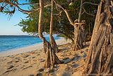
The land area consists of wetlands, forests, coast and the Paitchau mountain range in the south with its limestone cliffs typical of East Timor. In the karst system there are caves, sinkholes and fresh water springs. There is also a mountain range in the north which, together with the Paitchau range, form the outer edge of the Fuiloro Plateau , the eastern part of which belongs to the park. The mountains and the south coast are covered with primary forest and probably form the largest closed area of remaining primary vegetation on Timor. The region around the floodplains of the Ira Lalaro and further west to the municipal capital Lospalos have been turned into grassland by humans. The Irasiquero flows south from the Ira Lalaro . The river disappears in a ponor , the sacred Mainina hole . The seashore beaches are covered with white sand. The coastal rainforests, coastal palm savannas, mangrove forests and freshwater wetlands are particularly worthy of protection.
From May to July, rain falls on average twice a week, from November to January there is two hours of heavy rain a day. This can lead to flooding, especially in the areas around the Ira Lalaro. From August to October it is hot and dry. But there are regional differences. The north of the Sucos Tutuala has an annual rainfall of 500 to 1000 mm and an eight-month dry season. In the south of the Sucos Mehara, the amount of precipitation reaches 1000 to 1500 mm annually with a dry season of five to six months. The average temperature is 23.6 to 31.8 ° C. Maximum temperatures can reach 38 ° C.
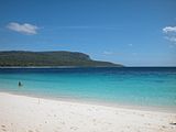
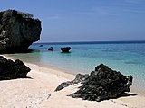
Jaco Island Beach

Lua Ira , the "monkey lake" near Com

View from Ile Kére Kére to the island of Jaco

Tropical forest near Lore

Underwater life near Jaco

The Ira Lalaro

Rock overhang in a small ravine near the Vero


.jpg)

fauna and Flora
| Bird species | status |
| Great cuckoo pigeon ( Macropygia magna ) | not endangered |
| Timor pigeon (Black Timor pigeon, Turacoena modesta ) | low risk |
| Green Timor Dove ( Treron psittaceus ) | endangered |
| Pink-headed fruit pigeon ( Ducula rosacea ) | low risk |
| Yellow-cheeked Cockatoo ( Cacatua sulphurea ) | threatened with extinction |
| Timor Parakeet ( Aprosmictus jonquillaceus ) | low risk |
| Timorliest ( Todiramphus australasia ) | low risk |
| Temminck honey eater ( Meliphaga reticulata ) | not endangered |
| Timor leather head ( Philemon inornatus ) | not endangered |
| Timor Honeyeater ( Lichmera flavicans ) | not endangered |
| Tricolor honeyeater ( Myzomela vulnerata ) | not endangered |
| Timorgerygone ( Gerygone inornata ) | not endangered |
| Orpheus thick head ( Pachycephala orpheus ) | not endangered |
| Fig pyrole ( Sphecotheres viridis ) | not endangered |
| Sundapirol ( Oriolus melanotis ) | not endangered |
| Timorese tail ( Urosphena subulata ) | not endangered |
| Timor Warrior ( Phylloscopus presbytes ) | not endangered |
| Spotted-breast- eyed bird ( Heleia muelleri ) | low risk |
| Timor Thrush ( Zoothera peronii ) | low risk |
| Timor wheatear ( Saxicola gutturalis ) | low risk |
| Chest-band groundcatcher ( Ficedula timorensis ) | low risk |
| Hyacinth flycatcher ( Cyornis hyacinthinus ) | not endangered |
| Macklot mistletoe ( Dicaeum maugei ) | not endangered |
| Sun nectar bird ( Cinnyris solaris ) | not endangered |
| Blue-green parrot finch ( Erythrura tricolor ) | not endangered |
The national park is home to numerous species that are endemic to Timor or Wallacea .
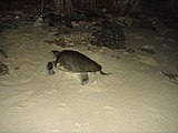
25 of the bird species in the park are so-called trigger species of the Timor and Wetar Endemic Bird Area (TWEBA), i.e. restricted-range species , which BirdLife International uses as a criterion for the Endemic Bird Area . Among them are the endangered yellow-cheeked cockatoo ( Cacatua sulphurea ) and the green Timor pigeon ( Treron psittaceus ). Mane deer ( Rusa timorensis ), wild boar, spotted cuscus ( Spilocuscus maculatus ), 16 species of bats and monkeys also live in the forests . Saltwater crocodiles can be found in the lake and on the coast . Sea turtles lay their eggs on several beaches on the south coast and on Jaco Island. Whales, dolphins, dugongs, and sharks can be seen in the coastal waters .
In 2007, a new Timorese subspecies of the McCord's neck turtle ( Chelodina mccordi ) was described for the first time , which lives on the Ira Lalaro. It shows features that they place between the McCord's snake- necked tortoise and Chelodina novaeguineae from New Guinea , which is why this taxon, called the Timor tortoise , is sometimes also viewed as a separate species, Chelodina timorensis .
The fish Craterocephalus laisapi occurs only in the Irasiquero . The hard-headed species was first discovered for science in 2005 and is one of only two freshwater fish species native to Timor. In 2013, another endemic fish species, Eviota santanai, was discovered in the shallow water of the coast .

Timor tortoise

Timor monitor in lore
Sea turtle laying eggs on Tutuala Beach
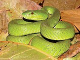
Island pit viper from the Ira Lalaro floodplain

Fringe-tailed house gecko in lore


.jpg)
It is estimated that there are 1200 to 1500 different plant species in the region. About 730 of them have been detected in the area of the national park so far. At least ten plant species in the national park are particularly worthy of protection. Three are on the IUCN Red List : Intsia bijuga , Pterocarpus indicus and Santalum album , whose sandalwood was Timor’s main export for centuries. Other potentially threatened species are Antiaris toxicaria , Neoalsomitra podagrica , Carallia brachiata and Eleocharis geniculata . Chromolaena odorata is considered to be the dominant weed species, but is absent in the primary forests and grasslands of the floodplain.
Historic and culturally significant sites


There are several caves and rock overhangs near the beach, where cave paintings and other traces of prehistoric settlement can be found. So the rock overhang of Ile Kére Kére and the cave of Lene Hara . Also near Tutuala is the Jerimalai limestone cave , where 42,000 year old archaeological finds were discovered, the oldest traces of human settlement on the Lesser Sunda Islands . In total, there are over 100 archaeological sites within the boundaries of the national park, including numerous fortifications of the indigenous population from the pre-colonial period and holy sites of the animistic religion of Timor . With over 25 rock art sites and one with stone engravings, the national park has the largest and most diverse collection of prehistoric paintings in all of Southeast Asia. They are mainly found under limestone overhangs overlooking the sea, but also deeper in caves.
There are also legacies of the Portuguese colonial era. In Tutuala is the residence of the local colonial administrator, in Lore, Mehara and Com there are remnants of Portuguese fortresses and in other places other Portuguese buildings and ruins. During their occupation in World War II, the Japanese built eleven bunkers, the remains of which can still be found. They also used several caves as storage rooms. The road from Tutuala to Muapitine was built by Timorese forced laborers among the Japanese. More detailed records of all the ruins from the time of the Battle of Timor are not yet available. As the former support of the East Timorese resistance against the Indonesian occupiers, the region is also of national historical importance. The caves served the FALINTIL fighters as hiding places.
Traditional ceremonies are still practiced, such as the mechi , the gathering of meci worms ( Eunice viridis ) at certain points along the coast. The smaller Mechi kiik takes place in the last quarter of the moon in February and the large Mechi boat at the new moon in March . The harvest of this maritime annelid marks the beginning of a new annual cycle for agriculture and is celebrated with festivities in the villages.
Management

In addition to some fishing (with hooks) and livestock farming (on the plain around the lake and around Tutuala and Com), agriculture is also practiced in the villages in the national park. The forest continues to be used as a supplier of firewood and food. 87.7% of the income of the residents in the national park comes from agriculture and the breeding of chickens, cattle, water buffalo, goats and pigs. By means of slash and burn, areas were created for the cultivation of maize, cassava , yams and beans, which form the main basis of the largely vegetarian diet of the population. Wet rice and tobacco are grown in smaller quantities. Pets are only slaughtered for special celebrations, such as weddings and funerals. The fishing and the actually forbidden hunting of monkeys, cousins , deer and feral pigs provide a basic supply of proteins for the people. Around the Ira Lalaro, the residents breed bream and catfish during the floods .
In addition, tourism is slowly developing, from which the local population as well as the employment as park rangers should benefit. In Tutuala there is a small guest house ( pousada ) in the former seat of the local Portuguese colonial administrator. A small beach resort has been established in Com and an Eco-Village has been set up on the beach in Valu near Tutuala , which is run by a local cooperative. But saltwater crocodiles are a particular danger for bathing and diving tourists. In 2007 and 2008 there were fatal crocodile attacks on Com Beach.
Organized tours also have Com and Jaco as destinations in the program, and fishermen also drive individual tourists to the island. However, there are no tours organized by the park.
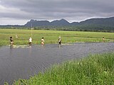
Malahara and Mehara women fish for catfish and tilapias . Saltwater crocodiles up to 4 m long also live in the river

Fields at Mehara

Bateng cattle in the floodplain north of the Ira Lalaro

Pousada of Tutuala , former seat of the Portuguese colonial administrator
Beach of Com

The drive to the beach of Valu is only possible with an off-road vehicle
Valu beach across from Jaco


Threats
Slash and burn to create fields is considered to be the greatest threat to the national park. There is also illegal deforestation and hunting of mammals, birds and turtles, browsing by domestic animals in the forest, illegal fishing by foreign fishermen (also with dynamite and poison) and pollution from garbage and sewage (especially on the beaches). Uncontrolled and unauthorized entry to holy places is also seen as a problem. Jaco's traditional entry ban is no longer observed. Only staying overnight on the island is still prohibited.
In general, the local population should participate in the protection of the park, but so far only six local rangers have been designated.
See also
literature
- Ian Cowie: A Survey of Flora and Vegetation of the Proposed Jaco – Tutuala – Lore National Park, Timor-Leste (East Timor) , NT Herbarium (DNA), Department of Natural Resources, Environment and the Arts, Palmerston, Northern Territory (NT ), May 2006.
- K. Edyvane et al .: The Timor-Leste Coastal / Marine Habitat Conservation Values, Issues and Planning in the Nino Konis Santana Marine Park, Timor Leste - Final Report. ( Memento from March 29, 2013 in the Internet Archive ) Ministry of Agriculture & Fisheries, Government of Timor Leste, 2009. (PDF; 9.2 MB)
- Hinrich Kaiser et al .: The herpetofauna of Timor-Leste: a first report. In: ZooKeys. Vol. 109, 2011, pp. 19-86, doi : 10.3897 / zookeys.109.1439 ( online ).
- John Norman Miksic, Geok Yian Goh, Sue O'Connor : Rethinking Cultural Resource Management in Southeast Asia: Preservation, Development, and Neglect. Anthem Press, 2011, ISBN 978-0-85728-389-4 .
Web links
- Brochure of the National Park Nino Konis Santana (English; PDF; 3.8 MB)
Individual evidence
- ↑ a b c d e f g h i j k l m brochure of the National Park Nino Konis Santana (English; PDF; 3.8 MB), accessed on December 25, 2012
- ↑ Alexander Cullen: A Political Ecology of Land Tenure in Timor Leste: Environmental Contestation and Livelihood Impacts in the Nino Konis Santana National Park. (PDF; 1.0 MB) In: Peskiza foun kona ba / Novas investigações sobre / New Research on / Penelitian Baru mengenai Timor-Leste. Swinburne Press, Hawthorn (Victoria) 2012, pp. 158-165, accessed March 16, 2013.
- ↑ AFP : ETimor sets up first national park. July 31, 2007, accessed March 16, 2013.
- ↑ Direcção-Geral de Estatística : Results of the 2015 census , accessed on November 23, 2016.
- ↑ a b c BirdLife International - News: Timor-Leste (formerly East Timor) declares first national park , August 3, 2008, accessed on March 16, 2013.
- ^ A b c d Ian Cowie: A Survey of Flora and Vegetation of the Proposed Jaco – Tutuala – Lore National Park, Timor-Leste (East Timor) , NT Herbarium (DNA), Department of Natural Resources, Environment and the Arts, Palmerston , Northern Territory (NT), May 2006, accessed March 16, 2013.
- ↑ Lautém District Development Plan 2002/2003, p. 3. ( Memento of February 3, 2011 in the Internet Archive ) (English; PDF file; 1.97 MB, accessed on March 16, 2013).
- ↑ BirdLife International - Important Bird Areas (IBAs): TL07 Monte Paitchau (proposed Conis Santana National Park) , accessed December 26, 2012.
- ↑ BirdLife International - Important Bird Areas (IBAs): TL 06 Lore , accessed on December 26, 2012.
- ↑ BirdLife International - Important Bird Areas (IBAs): TL08 Jaco Island , accessed December 26, 2012.
- ↑ BirdLife International - Important Bird Areas (IBAs): TL13 Tasitolu Peace Park , accessed March 16, 2013.
- ↑ Gerald Kuchling, Anders GJ Rhodin, Bonggi R. Ibarrondo, Colin R. Trainor: A New Subspecies of the Snakeneck Turtle Chelodina mccordi from Timor-Leste (East Timor) (Testudines: Chelidae) . In: Chelonian Conservation and Biology 6 (2): 213-222. 2007 doi : 10.2744 / 1071-8443 (2007) 6 [213: ANSOTS] 2.0.CO; 2 .
- ↑ Hinrich Kaiser et al .: The herpetofauna of Timor-Leste: a first report. In: ZooKeys. Vol. 109, 2011, pp. 19-86, doi : 10.3897 / zookeys.109.1439 ( online , accessed March 16, 2013).
- ↑ Craterocephalus laisapi on Fishbase.org (English), accessed March 16, 2013.
- ↑ Country's First New Species of Fish Discovered, December 11, 2013 , accessed December 13, 2013
- ↑ Peter V. Lape: Chronology of Fortified Settlements in East Timor. In: Journal of Island & Coastal Archeology. Vol. 1, No. 2, 2006, pp. 285–297, doi : 10.1080 / 15564890600939409 ( PDF ; 2.2 MB, accessed on March 16, 2013).
- ↑ a b John N. Miksic, Geok Yian Goh, Sue O'Connor: Rethinking cultural resource management in Southeast Asia: preservation, development, and neglect. Anthem Press, 2011, p. 43ff.
- ↑ K. Edyvane et al .: Coastal and Marine Ecotourism Values, Issues and Opportunities on the North Coast of Timor Leste. ( Memento of March 29, 2013 in the Internet Archive ) Ministry of Agriculture & Fisheries, National Directorate of Tourism, Government of Timor Leste, 2009 (PDF; 15.2 MB, accessed December 28, 2012).
- ↑ a b c K. Edyvane et al .: The Timor-Leste Coastal / Marine Habitat Conservation Values, Issues and Planning in the Nino Konis Santana Marine Park, Timor Leste - Final Report. ( Memento of March 29, 2013 in the Internet Archive ) Ministry of Agriculture & Fisheries, Government of Timor Leste, 2009 (PDF; 9.2 MB, accessed on December 28, 2012).
- ↑ a b Lisa Palmer, Demétrio do Amaral de Carvalho : Nation building and resource management: The politics of 'nature' in Timor Leste In: Geoforum. Vol. 39, No. 3, 2008, pp. 1321–1332, doi : 10.1016 / j.geoforum.2007.09.007 ( PDF ( Memento of the original from February 1, 2014 in the Internet Archive ) Info: The archive link was automatically inserted and not yet checked. Please check the original and archive link according to the instructions and then remove this note .; 343 kB, accessed on March 16, 2013).
- ↑ Valu-Sere and Jaco Island ( Memento from December 14, 2012 in the Internet Archive )
- ^ Eco Discovery East Timor , accessed March 16, 2013.
- ^ UNDP: Supporting Country Action on the CBD Program of Work on Protected Areas ( Memento from February 9, 2011 in the Internet Archive ) (PDF; 259 kB, accessed January 5, 2013).