Niederwerth
| coat of arms | Germany map | |
|---|---|---|

|
Coordinates: 50 ° 24 ' N , 7 ° 37' E |
|
| Basic data | ||
| State : | Rhineland-Palatinate | |
| County : | Mayen-Koblenz | |
| Association municipality : | Vallendar | |
| Height : | 68 m above sea level NHN | |
| Area : | 3.03 km 2 | |
| Residents: | 1259 (Dec. 31, 2019) | |
| Population density : | 416 inhabitants per km 2 | |
| Postal code : | 56179 | |
| Area code : | 0261 | |
| License plate : | MYK, MY | |
| Community key : | 07 1 37 218 | |
| Association administration address: | Rathausplatz 13 56179 Vallendar |
|
| Website : | ||
| Local Mayor : | Horst Klöckner (FWG) | |
| Location of the community Niederwerth in the district of Mayen-Koblenz | ||

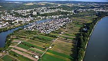
Niederwerth is a local community and an inland island in the Rhine three kilometers north of Koblenz . It is located in the Mayen-Koblenz district in Rhineland-Palatinate and belongs to the Vallendar community .
Niederwerth is - unique in Germany - an independent river island community.
geography
The community Niederwerth consists of the Rhine islands Niederwerth and Graswerth . While Niederwerth is inhabited, Graswerth is an uninhabited nature reserve . Both islands are located towards the east of the Rhine city of Vallendar , with the island Niederwerth is connected via the right arm of the Rhine since 1958 over a bridge. Since the municipality is used intensively for fruit and vegetable cultivation (asparagus and strawberries), the bridge to the other arable land of the farmers around Vallendar was financed from funds from the Green Plan . Previously, the island was connected by a ferry. A passenger shipping line also connects with Koblenz.
On the southern tip of the island there is an overhead line mast that is part of the Rhine overhead line crossing Koblenz-Niederwerth-Urbar .
The two islands account for 1.71 km² of the municipality's area of 3.03 km² (1.4 km² on the island of Niederwerth and 0.3 km² on Graswerth). The rest is water, the share of the municipality on the Rhine and its branches.
history
Grave finds prove that Niederwerth was already settled in the 8th century.
The former Niederwerth monastery , located on the southern outskirts, emerged from an early settlement first mentioned in a document in the 13th century . From the 15th century it was a settlement of Augustinian canons and from the 16th century a Cistercian abbey. In 1811 this was canceled. The preserved single-nave late Gothic monastery and today's Catholic branch church of St. George (consecrated in 1474) preserves not only remarkable wall paintings, but also rich furnishings from Gothic, Baroque and Neo-Gothic.
In the First Coalition War (1792–1797) the island Niederwerth played an important role due to its strategic location in relation to the siege of the Ehrenbreitstein Fortress . The French maintained a weapons and ammunition depot on the island for their siege troops. The island was alternately occupied by Austro-Hungarian troops and French; Agriculture has long since leveled the countless ditches, ramparts and earth entrenchments. On October 30, 1795, Prince Ferdinand von Württemberg took "the Niederwerth" from the French, which was occupied by 800 French.
On November 29, 1795, the communication bridge to the island of Niederwerth was "shot into the ground" by gun batteries under the orders of Major General Adam Boros de Rakos (1739-1809) from the Ehrenbreitstein Fortress. On the night of November 30, 1795, the Württemberg and Murray divisions landed at the lower tip of the island, they stormed the fortified monastery and its former entrenchments, drove the entire French island crew to the upper tip, where they wanted to retreat on six barges. But the gun batteries directed there prevented this retreat and so all who were not pushed into the floods of the Rhine had to surrender to captivity. These consisted of a colonel, 20 officers and 650 commons.
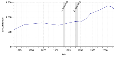
- Population development
The development of the population of Niederwerth, the values from 1871 to 1987 are based on censuses:
|
|
politics
Municipal council
The municipal council in Niederwerth consists of 16 council members, who were elected in a personalized proportional representation in the local elections on May 26, 2019 , and the honorary local mayor as chairman.
The distribution of seats in the municipal council:
| choice | SPD | CDU | FWG | total |
|---|---|---|---|---|
| 2019 | 4th | 2 | 10 | 16 seats |
| 2014 | 8th | 3 | 5 | 16 seats |
| 2009 | 8th | 3 | 5 | 16 seats |
| 2004 | 6th | 5 | 5 | 16 seats |
- FWG = Free Voter Group Niederwerth e. V.
mayor
Local mayor of Niederwerth is Horst Klöckner (FWG). In the direct election on May 26, 2019, he was elected with a share of the vote of 75.61% and is the successor to Josef Gans (SPD), who did not run again after 15 years in office.
partnership
The municipality has been associated with Pontaumur in Auvergne since 1977 . The partnership emerged from the personal experiences of a prisoner of war from the community and developed from club activities.
Infrastructure
Niederwerth has a kindergarten, a primary school and a fire brigade unit. The community building offers space for a community library and activities of the clubs.
See also
literature
- Gunnar and Rüdiger Mertens: The former monastery in Niederwerth near Koblenz (= Rheinische Kunststätten Heft 223). Neusser Druckerei und Verlag, Neuss, 2nd edition, 1987, ISBN 3-88094-572-1 .
- Rainer M. Schröder : The secret of the white monks : Roman (= arena paperback, 2150). Arena , Würzburg, 2002, ISBN 3-401-02150-8 .
Web links
- Website of the local community Niederwerth
- Literature about Niederwerth in the Rhineland-Palatinate State Bibliography
Individual evidence
- ↑ State Statistical Office of Rhineland-Palatinate - population status 2019, districts, communities, association communities ( help on this ).
- ↑ Niederwerth at the partnership association ( Memento from November 27, 2013 in the Internet Archive )
- ^ Leopold Bleibtreu : Memories from the war events at Neuwied from 1792 to 1797 , Bonn 1834, printed by Carl Georgi, page 72
- ↑ Fourteenth special by-page for Wiener Zeitung No 88 Freytag on November 6, 1795
- ↑ State Statistical Office Rhineland-Palatinate - regional data
- ↑ The Regional Returning Officer: Local elections 2019, city and municipal council elections
- ^ The Regional Returning Officer Rhineland-Palatinate: Municipal elections 2014, city and municipal council elections
- ^ The State Returning Officer Rhineland-Palatinate: direct elections 2019. see Vallendar, Verbandsgemeinde, first line of results. Retrieved November 10, 2019 .


