Obernstrasse (Bremen)
| Obernstrasse | |
|---|---|
| Street in Bremen | |
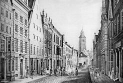
| 1844: View towards the market square and cathedral | |
| Basic data | |
| city | Bremen |
| District | Old town |
| Created | middle Ages |
| Newly designed | 2000s |
| Cross streets | Sögestrasse , Kleine and Große Waagestrasse, Kahlenstrasse, Pieperstrasse, Papenstrasse |
| Buildings | Rohlandseck house , bank and department store Obernstraße 2–12 , Karstadt department store |
| use | |
| User groups | Tram and pedestrians |
| Road design | Pedestrian zone, two tram tracks |
| Technical specifications | |
| Street length | 380 meters |
The main street is part of a vast pedestrian area , the main shopping street in Bremen . It leads in an east-west direction from the market square and Unser-Lieben-Frauen-Kirchhof to the Ansgarikirchhof , where it joins Hutfilterstraße , with which it forms a continuous street.
The cross streets were named u. a. as Sögestraße , Kleine and Große Waagestraße, Kahlenstraße, Pieperstraße and Papenstraße.
In the 2011 ranking of the most popular shopping streets in Germany, Obernstrasse ranks 15th with 8175 pedestrians per hour.
history

Surname
Obernstraße was named after its location in the higher ( overen = upper) area of the old town on the Bremen dune and after the field name platea superior (mentioned in 1157). It lay above the parallel Langenstrasse and significantly higher than the Tiefer situated on the Weser . In 1374 it was called Overenstrate .
development
Along with Langenstrasse and Sögestrasse, the street was one of the first main streets of medieval Bremen. In 1157 it was first mentioned in connection with a donation (Bremer Weidebrief ) to the cathedral chapter as "platea superior civitas". The first Bremen town hall was located on the corner of Obernstrasse and Sögestrasse in the 13th century. Since 1649 the Obernstrasse, which - as it says in the council documents from that time - "should be the most prominent adaptation and at the same time an ornament and ornament of this good city" has been cleaned regularly.
In the Middle Ages, the street connected the church districts Our Dear Women and St. Stephen's . The Gothic hall church of St. Ansgarii was destroyed by the collapse of the tower in 1944 and its ruins were demolished in several stages by 1956. In its place, the Hertie department store was built, which had to give way to a new building complex in the 1980s.
Today only the name Ansgarii-Kirchhof and a stele in the square remind of the impressive church building . A plate on the southeast corner of the square indicates the location of the spire, which Carl Friedrich Gauß , Johann Hieronymus Schroeter , Heinrich Wilhelm Olbers and Friedrich Wilhelm Bessel used as a trigonometric survey point .
At the beginning of the 19th century, residential buildings dominated the street. The serial killer Gesche Gottfried also lived in Obernstrasse from 1821 to 1824 . Gradually, the residential buildings were replaced by office and shop buildings in the historicizing style of the second half of the 19th century.
In 1845, the Sparkasse Bremen moved into rented rooms at Obernstraße 11 (today 17-19) and acquired the house in 1853. From 1882 to 1906 it had its third office building on the corner of Obernstraße and Papenstraße.
For the monumental new building of the Karstadt department store, which was built from 1930 to 1932 , several old buildings on the north side of Obernstrasse had to give way.
In 1944, almost all buildings on Obernstrasse were completely destroyed in the Second World War . The bank and department store Obernstrasse 2-12 of the Schröder-Bank and the North German credit bank , in which the department store Peek & Cloppenburg is located today , was retained. The burned out Karstadthaus was rebuilt while preserving the facade.
Today there are almost exclusively department stores and retail stores in Obernstrasse, and mostly offices on the upper floors.
traffic
The Bremen tram has been running through Obernstrasse since 1879, initially as a horse-drawn tram, electrified since 1900.
Obernstrasse has been a pedestrian zone since December 1963 - at that time, however, only between Pieperstrasse and Liebfrauenkirchhof, and delivery traffic was allowed to stop on the south side early in the morning from 6 a.m. to 10 a.m. The tram stayed and at that time set up the new "Obernstraße" stop between Brill and Marktplatz, initially east of Pieperstraße, and since 1965 further east directly in front of the Karstadt entrance.
The Bremen tram runs today through Obernstraße with line 2 ( Gröpelingen - Sebaldsbrück ) and line 3 (Gröpelingen - Weserwehr ).
building
- Corner house Obernstraße / Unser-Lieben-Frauen-Kirchhof: House Rohlandseck according to plans by Carl Eeg from 1914 and 1959
- No. 1: Furniture store Carl Haake around 1849
- No. 2–12: Bank and department store Obernstrasse 2–12 : New bank building from 1923 to 1931 Bankhaus J. F. Schröder according to plans by Wellermann and Frölich , from 1931 to around 2000 Norddeutsche Kreditbank , since 1980 also the seat of the Bremen Stock Exchange , since 2003 remodeling to the Peek & Cloppenburg department store based on plans by Manfred Schomers and Rainer Schürmann
- No. 5–19, later 5–33: Karstadt commercial building based on plans by Friedrich Neumark and Heinrich Wilhelm Behrens from 1930–32, the building has been preserved, the facade is a listed building
- Nr.?/Ecke Kreyenstraße: residential tower of the Casal brotherhood in the 14th century, residence of the merchant Burchard Lösekanne until 1654
- No. 10: Franz Neelmeyer's brokerage firm from 1907 to 1923
- No. 11: Friedrich Adolph Dreyer's print shop around 1824, Carl Schünemann's “Museum der neue Literatur” bookstore around 1830 to 1833, later Carl Haake furniture store
- No. 20: Café Jacobs based on plans by Julius Schulte-Frohlinde was open from 1950 to 2018.
- No. 21–27, later 21–33: Heymann & Neumann department store , 1912, expansion and renovation 1929–30, architects Behrens and Neumark, Bremen. Aryanized in 1934 by Gustav Cords, Berlin. 1/3 destroyed in 1944, demolished around 1953.
- No.?: Sparkasse Bremen from 1845 to 1882
- No. 32: Workshop, shop and apartments of the silverware manufacturer Koch & Bergfeld from 1863 to 1875
- No. 35: Carl Schünemann's bookstore from 1833 to 1835
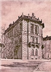
- Corner of Obernstrasse / Papenstrasse: New bank building of the Sparkasse Bremen based on plans by Johann Georg Poppe from 1882 to 1918
- No. 45: Watchmaker and photographer Peter Heinrich August Wolff's business since 1823
- No. 66: Hertie department store from 1960s to 1986, new building of the "Bremer Carrée"
- No. 78/80: Bremische Volksbank until 1941
Personalities
In earlier centuries Obernstraße was also the residence of Bremen personalities:
- Nikolaus Hemeling (before 1361-1391), Mayor of Bremen
- Gerhard Castendyk (1769–1801), lawyer and Bremen senator (1798–1801)
- Simon Henrich Gondela (1765–1832), lawyer and Senator from Bremen (1792–1816)
- Albert Löning (1767–1849), businessman and Senator from Bremen (1816–1849), lived at Obernstrasse 12 around 1812 to 1841 and then Am Wall
- Gesche Gottfried , the poisoner lived in Obernstrasse around 1823/24
Monument protection
The following buildings are currently under monument protection :
- Obernstrasse / corner of Sögestrasse 1: Commercial building (ex Brinkmann and Lange)
- Obernstrasse / corner of Kirchhof 26: Rohlandseck house, residential and commercial building
- Obernstraße / corner of Sögestraße: Karstadt department store facade
- Obernstrasse 2 to 12: Schröderbank or the Norddeutsche Kreditbank, today Peek & Cloppenburg department store
→ See the list of cultural monuments in Bremen-Mitte
Monuments
- Animal fountain made of bronze and brass-copper, corner of Obernstrasse / Sögestrasse by Manfred Lohrengel (1974)
- At the corner of Obernstrasse and Ansgarikirchhof there is a notice board about Heinrich Wilhelm Olbers' surveying work . The fundamental point was about ten meters away in the building that is now Hanse Carrée .
See also
Web links
Individual evidence
- ^ Jones Lang LaSalle : Pedestrian Frequencies 2011
- ^ Klaus Schwarz: Companies, parishes and convents in Bremen 1606–1814 . In: Karl H. Schwebel (Ed.): Publications from the State Archives of the Free Hanseatic City of Bremen . tape 37 . Carl Schünemann, Bremen 1871, ISBN 978-3-11-000041-2 , p. 73 .
- ↑ Chronology of the Bremen Tram ( Memento from February 15, 2014 in the Internet Archive ) (former BSAG website)
- ↑ a b Obernstrasse becomes a pedestrian zone between Pieperstrasse and Liebfrauenkirchhof - the tram has free passage, Weser-Kurier of December 13, 1963, p. 9, online only for subscribers
Coordinates: 53 ° 4 ′ 39 ″ N , 8 ° 48 ′ 17 ″ E


