
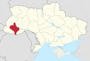
Ivano-Frankivsk Oblast
| Ivano-Frankivsk Oblast | |
|---|---|
| Івано-Франківська область / Iwano-Frankiwska oblast | |

|

|
| Basic data | |
| Oblast center : | Ivano-Frankivsk |
| Official languages : | Ukrainian |
| Residents : | 1,382,100 (2014) |
| Population density : | 99.23 inhabitants per km² |
| in cities : | 42.2% |
| Area : | 13,928 km² |
| KOATUU : | 2600000000 |
| License plate : | AT, KT |
| Administrative division | |
| Rajons : | 14th |
| Cities : | 15th |
| managed by Oblast: | 6th |
| administered by Rajon: | 9 |
| Urban-type settlements : | 24 |
| Villages: | 745 |
| Settlements : | 20th |
| Contact | |
| Address: | вул. Грушевського 21 76004 м. Івано-Франківськ |
| Website: | Official website |
| map | |
 .svg) |
|
| Statistical information | |
The Ivano-Frankivsk Oblast ( Ukrainian Івано-Франківська область Ivano-Frankiwska oblast - to 1962 Станіславська область Stanislawska oblast , Russian Ивано-Франковская область Ivano-Frankowskaja oblast ) called Region is an administrative unit of Ukraine in the southwest of the country. It has around 1.38 million inhabitants (2014). The oblast is part of the historic Galicia landscape .
The capital is Ivano-Frankivsk , other cities are Kalush , Burschtyn and Kolomyja . In the south, the Carpathian Mountains form the border with Romania . On the border with the Transcarpathian Oblast is the Hoverla , the highest mountain in Ukraine at 2,061 meters. In the northwest the oblast borders on the Lviv Oblast , in the northeast on the Ternopil Oblast , in the southeast on the Chernivtsi Oblast and in the southwest on the Zakarpattia Oblast.
history
The oblast was created as Stanislaw / Stanyslawiw Oblast (Russian / Ukrainian) after the occupation of Eastern Poland by the Soviet Union as part of the Ukrainian SSR by ukase on December 4, 1939 from most parts of the previous Polish Voivodeship Stanislau . Initially, the following formerly Polish powiate ( called Ujesd in Russian ) were retained:
- Gorodenka / Horodenka (Городенковский уезд)
- Dolina (Долинский уезд)
- Kalusch / Kałusz (Калушский уезд)
- Kolomyja / Kołomyja (Коломыйский уезд)
- Kossow / Kosów (Косовский уезд)
- Nadwornaja / Nadwórna (Надворнянский уезд)
- Rogatin / Rohatyn (Рогатинский уезд)
- Snjatyn / Śniatyn (Снятынский уезд)
- Stanislaw / Stanisławów (Станиславский уезд)
- Tlumatsch / Tłumacz (Тлумачский уезд)

After deliberations on January 10, 1940, the Ujesde was dissolved on January 17, 1940 and replaced by the following Rajons (the Russian names are given as they reflect the official names of the time):
- Bohorodchany district with Bohorodchany district center (Богородчаны)
- Bolschowzy Rajon with Bolschowzy Rajonszentrum (Большовцы)
- Bolechow district with Bolechow district center (Болехов)
- Rayon Bukatschjowzy with Rajonszentrum Bukatschjowzy (Букачёвцы)
- Burschtyn Raion with Burschtyn Raion Center (Бурштын)
- Galitsch Rajon with Galitsch Rajonszentrum (Галич)
- Gwosdez district with Gwosdez district center (Гвоздец)
- Gorodenka district with Gorodenka district center (Городенка)
- Deljatin district with Deljatin district center (Делятин)
- Dolina district with Dolina district center (Долина)
- Jablonow district with Jablonow district center (Яблонов)
- Kalush district with Kalush district center (Калуш)
- Kolomyja district with Kolomyja district center (Коломыя)
- Korschew Rajon with Korschew Rajonszentrum (Коршев)
- Kossow Raion with Kossow Raion Center (Косов)
- Kuty district with Kuty district center (Куты)
- Lanchin district with Lanchin district center (Ланчин)
- Lissez district with Lissez district center (Лисец)
- Mikulitschin district with Mikulitschin district center (Микуличин)
- Nadwornaja district with Nadwornaja district center (Надворная)
- Novitsa district with Novitsa district center (Новица)
- Obertin district with Obertin district center (Обертин)
- Otynija district with Otynija district center (Отыния)
- Rogatin District with Rogatin District Center (Рогатин)
- Zabolotov Raion with Zabolotov Raion Center (Заболотов)
- Rayon Schabje with Rajonszentrum Schabje (Жабье)
- Shovten district with Shovten district center (Жовтень)
- Snyatyn district with Snyatyn district center (Снятын)
- Solotvin district with the Solotvin district center (Солотвин)
- Stanislav district with Stanislav district center (Станислав)
- Tlumach district with Tlumach district center (Тлумач)
- Chernelitsa Raion with Chernelitsa Raion Center (Чернелица)
- Rayon Wygoda with Rajonszentrum Wygoda (Выгода)
- Voinilow district with Voinilow district center (Войнилов)
Then came the independent city of Stanislaw. As late as 1940, the Rajone Mikulitschin in Rajon were Yaremche , Nowiza in Pereginskoje and Deljatin in Petscheneschin renamed by reorganization of Rajon Tysmeniza with Rajonszentrum came Tysmeniza (Тысменица) added so that now 36 Rajone existed.

However, the oblast was dissolved again after Germany's invasion of the Soviet Union on June 22, 1941, the area was largely absorbed in the Galicia district and could only be restored after the area was recaptured by the Red Army in 1944.
On June 6, 1957, the Vyhoda, Shovten, Kuty, Pechenischyn and Chernelytsia Rajons were dissolved, and on March 11, 1959, Bukachivtsi, Korschiw, Perehinske and Zolotvyn followed.
On November 9, 1962, the oblast was renamed, analogous to the renaming of the oblast capital in Ivan Frankivsk Oblast, in memory of Ivan Franko , shortly afterwards on December 30, 1962 the Rajons Bolekhiv, Bilschiwzi, Burschtyn, Wojnyliw, Hwisdez, Sabolotiw, Lanchyn, Lyssez , Nadwirna, Obertyn, Rohatyn, Roschnjatiw, Snjatyn, Stanyslaviw, Tlumach, Tysmenyzja, Yabluniv and Yaremcha dissolved and divided among the remaining Rajons. The Rajon Shabje, however, was renamed analogous to the eponymous capital of the Rajon Verkhovyna Rajon (Верховина), but was also dissolved on October 28, 1963.
At the end of 1963 the following Rajons existed:
- Bohorodchany Raion
- Halych district
- Horodenka Raion
- Kalush district
- Kolomyja district
- Kosiv Raion
In addition there was the industrial bayon Dolyna, which included the city of Dolyna.
On January 4, 1965, these borders were changed again and the Rajons Nadwirna, Rohatyn, Roschnjatiw, Snjatyn and Tlumatsch with new borders emerged, on December 8th 1966 the Rajons Verkhovyna and Ivano-Frankivsk followed, from the latter the present Rajon emerged in 1982 Tysmenitsa .
Biggest cities
| city | Ukrainian name | Russian name | Resident January 1, 2006 |
|---|---|---|---|
| Ivano-Frankivsk | Івано-Франківськ | Ивано-Франковск | 220,721 |
| Kalush | Калуш | Калуш | 67,339 |
| Kolomyia | Коломия | Коломыя | 61,048 |
| Nadwirna | Надвірна | Надворная | 21,319 |
| Dolyna | Долина | Долина | 20,641 |
| Burschtyn | Бурштин | Бурштын | 15,153 |
| Bolekhiv | Болехів | Болехов | 10,485 |
| Sniatyn | Снятин | Снятын | 10,285 |
| Tysmenitsa | Тисмениця | Тысменица | 9,564 |
| Horodenka | Городенка | Городенка | 9,479 |
| Tlumach | Тлумач | Тлумач | 8,741 |
| Rohatyn | Рогатин | Рогатин | 8,285 |
| Kosiv | Косів | Косов | 8,236 |
Administrative division
The Ivano-Frankivsk Oblast is administratively divided into 14 Rajons and 6 cities directly subordinate to the Oblast administration. These are the cities of Yaremche , Bolechiv , Kalush , Kolomyja , Burschtyn and the eponymous administrative center of the oblast, the city of Ivano-Frankivsk .
Ivano-Frankivsk Oblast Rajons and their administrative centers

| Ivano-Frankivsk Oblast Rajons | ||
|---|---|---|
| German name | Ukrainian name | Administrative center |
| Bohorodchany Raion | Богородчанський район Bohorodchanskyj rajon |
Bohorodchany (urban-type settlement) |
| Verkhovyna Raion | Верховинський район Verkhovynskyj rajon |
Verkhovyna (urban-type settlement) |
| Halych district | Галицький район Halyzkyj rajon |
Halytsch (city) |
| Horodenka Raion | Городенківський район Horodenkiwskyj rajon |
Horodenka (city) |
| Dolyna district | Долинський район Dolynskyj rajon |
Dolyna (city) |
| Kalush district | Калуський район Kaluskyj rajon |
Kalush (city) |
| Kolomyja district | Коломийський район Kolomyjskyj rajon |
Kolomyja (city) |
| Kosiv Raion | Косівський район Kosivskyj rajon |
Kosiv (city) |
| Nadvirna district | Надвірнянський район Nadvirnjanskyj rajon |
Nadwirna (city) |
| Rohatyn district | Рогатинський район Rohatynskyj rajon |
Rohatyn (city) |
| Roschnyativ district | Рожнятівський район Roschnjatiwskyj rajon |
Roschnyativ (urban-type settlement) |
| Snyatyn Raion | Снятинський район Snjatynskyj rajon |
Snjatyn (city) |
| Tysmenitsya district | Тисменицький район Tysmenyzkyj rajon |
Tysmenytsia (city) |
| Tlumach district | Тлумацький район Tlumachkyj rajon |
Tlumatsch (city) |
Demographics
| year | 1989 | 1990 | 1995 | 1998 | 2001 | 2005 | 2008 | 2012 | 2014 |
|---|---|---|---|---|---|---|---|---|---|
| Residents | 1,423,500 | 1,431,400 | 1,466,800 | 1,448,200 | 1,420,200 | 1,393,616 | 1,382,603 | 1.380.128 | 1,382,100 |
| nationality | Residents | 1989 (%) | 2001 (%) | Change (%) |
|---|---|---|---|---|
| Ukrainians | 1,371,200 | 95.0 | 97.5 | + 2.1% |
| Russians | 24,900 | 4.0 | 1.8 | −56.3% |
| native language | 1989 (%) | 2001 (%) |
|---|---|---|
| Ukrainian | 94.9 | 97.8 |
| Russian | 5.1 | 1.8 |
| Others | 0.4 |
National park

In the area of the oblast lies the 515 km² Carpathian National Nature Park.
Web links
Individual evidence
- ↑ http://www.ukrstat.gov.ua/
- ↑ Указ Президиума ВС СССР от December 4, 1939 об образовании Волынской, Дрогобычской, Львобычской, Львобычской, Львобычской, Львобычской, Львовской, Львовской… Львовской
- ↑ http://www.history.org.ua/index.php?current_day=10¤t_manth=1&flag=1
- ↑ ukase of the Presidium of the Supreme Soviet of the USSR from 17.01.1940 "Про утворення районів в складі Волинської, Дрогобичської, Львівської, Ровненської, Станіславської і Тарнопольської областей УРСР"
- ↑ Президія Верховної Ради УРСР; Указ від 09.11.1962 № б / н "Про перейменування міста Станіслава і Станіславської області"
- ↑ Президія Верховної Ради УРСР; Указ від 12/30/1962 № 35 "Про укрупнення сільських районів Української РСР"
- ↑ Президія Верховної Ради УРСР; Указ від 04.01.1965 № 2н-06: "Про внесення змін в адміністративне районування Української РСР"
- ↑ Указ Президиума Верховного Совета от 11.03.1982 № 3210-X: "Про перенесення центру Івано-Франківського району Івано-Франківської області в селище міського типу Тисмениця і перейменування району на Тисменицький "
- ↑ http://www.ukrcensus.gov.ua/eng/
- ↑ http://www.ukrstat.gov.ua/
- ↑ http://2001.ukrcensus.gov.ua/eng/results/general/nationality/
- ↑ http://2001.ukrcensus.gov.ua/eng/results/general/language/Frankivsk/
Oblast : Kharkiv | Kherson | Khmelnytskyi | Dnepropetrovsk | Donetsk | Ivano-Frankivsk | Kiev | Kirovohrad | Luhansk | Lviv | Mykolaiv | Odessa | Poltava | Rivne | Zaporizhia | Zhytomyr | Sumy | Ternopil | Transcarpathia | Cherkassy | Chernihiv | Chernivtsi | Wolyn | Vinnytsia
Cities with subject status: City of Kiev | City of Sevastopol 1
Autonomous Republic: Crimea 1
1 areas annexed by Russia
Burschtyn | Bolekhiv | Dolyna | Halytsch | Horodenka | Ivano-Frankivsk | Yaremche | Kalush | Kolomyia | Kosiv | Nadwirna | Rohatyn | Snjatyn | Tlumatsch | Tysmenitsa
Bilzhivtsi urban-type settlements |
Bohorodchany |
Brochniv Ossada |
Bukachivtsi |
Bytkiw |
Delyatyn |
Hwisdez |
Jabluniw |
Jesupil |
Kuty |
Lanchyn |
Lyssez |
Obertyn |
Otynija |
Perehinske |
Pechenishyn |
Roshnyativ |
Sabolotiv |
Zolotvyn |
Chernelytsia |
Verkhovyna |
Voynyliv |
Vorokhta |
Wyhoda