
Oeschinensee
| Oeschinensee | ||
|---|---|---|

|
||
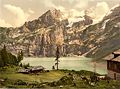
| View over the Oeschinensee to the Blüemlisalp | ||
| Geographical location | Bernese Oberland | |
| Tributaries | several glacial streams | |
| Drain | Öschibach | |
| Places on the shore | Kandersteg | |
| Data | ||
| Coordinates | 622 132 / 149 709 | |
|
||
| Altitude above sea level | 1578 m above sea level M. | |
| surface | 1,114 7 km² | |
| length | 1.6 km | |
| width | 1 km | |
| scope | 5.229 km | |
| Maximum depth | 56 m | |
|
particularities |
underground drain |
|

|
||

The Oeschinensee is located above Kandersteg ( Bernese Oberland ) in Switzerland . The water level is on average at an altitude of 1578 m . At normal water level, the lake is 56 m deep and has an area of 1.1 km², making it one of the larger mountain lakes in Switzerland. It was created by several landslides on the flanks of the Fründenhorn and the Doldenhorn .
Since 2007 the Oeschinensee has been part of the extended UNESCO World Natural Heritage Swiss Alps Jungfrau-Aletsch .
location
The lake is framed on the east and south by the three-thousanders Blüemlisalp , Oeschinenhorn , Fründenhorn and Doldenhorn , from whose glacier streams it is fed. The Öschibach (according to the Swiss national map with “Ö” instead of “Oe”) flows underground through the closure of the lake, but soon comes back to the light of day. Its water is used to supply Kandersteg with drinking water and to generate electricity . The Öschibach flows into the Kander in Kandersteg .
The approaches to the Blüemlisalp (2834 m) and Fründenhütte (2562 m) of the Swiss Alpine Club run past the Oeschinensee . The restaurants at Oeschinensee also offer overnight accommodation.
The lake can be reached from Kandersteg via several hiking trails or by gondola lift (GKO since 2008, previously chairlift with a lateral view). From the mountain station you can walk to the lake on a gently sloping route in around 25 minutes. In the summer season an electric vehicle is available between the mountain station of the gondola and the Oeschinensee. A hike leads from the mountain station over the Heuberg (1940 m, with a view of the lake and the surrounding three thousand meter peaks) to Alp Oberbärgli (1978 m), which is open in summer and from where you can descend via Alp Underbärgli to the restaurants on the lake.
Climbers who are free from giddiness and sure-footed can walk around the lake. The grass and rock bands of the so-called "Fründenschnur" allow an airy traverse from the Alp Underbärgli to the ascent to the Fründenhütte at an altitude of about 1800 m.
tourism
The Oeschinensee is a popular bathing lake in summer. There is a summer toboggan run at the mountain station of the gondola lift. At the lake there are two hotels with restaurants, several different barbecue areas and a rowboat rental.
Because of an unusually low snow cover, Oeschinensee was reopened to ice skaters for the first time in 19 years in December 2015. Thereafter, the sea freeze occurred again annually. At the beginning of January 2019, the ice skating season ended after a few days due to heavy snowfall and the ice surface was prepared for winter hiking .
Oeschinensee around 1900

Location of the Oeschinen lake below the Blüemlisalp

View from the ascent to the Fründenhütte

View from the Fründenschnur

The lake can be used as an ice rink at the end of 2015


See also
Web links
Individual evidence
- ↑ a b c Lakes (Federal Office for the Environment FOEN). Retrieved January 18, 2020 .
- ↑ UNESCO Jungfrau-Aletsch-Bietschhorn ( Memento from October 26, 2015 in the Internet Archive )
- ↑ Ice skating on the frozen Oeschinensee on Travelita.ch from December 26, 2015
- ↑ Good News! The Swiss Insta lake is open for ice skating in Watson from December 28th 2018
- ↑ The Oeschinensee is now waiting for the hikers in Der Bund from January 6, 2019
Swiss lakes with an area of over 1 km² (without artificial reservoirs ):
Aegeri | Baldeggersee | Lake Biel | Lake Constance | Lake Brienz | Lake Geneva | Greifensee | Hallwilersee | Lac de Joux | Lake Poschiavo | Langensee | Lauerzersee | Lake Lugano | Lungerersee | Lake Murten | Lake Neuchâtel | Oeschinensee | Pfäffikersee | Sarnersee | Sempachersee | Silsersee | Lake Silvaplana | Lake Thun | Lake Lucerne | Walensee | Lake Zug | Lake Zurich