
Fortification (Sulzbach am Main)

The fortification of Sulzbach am Main is a late medieval fortification that was built as a closed wall ring to protect the place. With twin towers, gates as well as kennels and defense paths behind the wall, it had typical features of a city fortification . The wall, made of red Main sandstone , was extensively restored from 2012 to 2015 and is a listed building (file number D-6-76-160-1 ).
location

In the late Middle Ages, the around one kilometer long fortification enclosed the site as a fortification. The upper gate, which was flanked by two round towers, was in the south (today the confluence of Pfortengasse and Jahnstrasse). In the north-west, access was controlled via the lower gate (today the transition from Hauptstrasse to Bahnhofstrasse), which was also flanked by two round towers. At the far corner in the southeast of the curtain wall was a round tower without a passage in the wall (today Jahnstrasse).
history
The dating of the fortification was set around 1500 as a closed wall ring. It surrounded the buildings and gardens of the village, which then had around 500 inhabitants. Originally there were two gates flanked by round towers with a kennel, which were located in the north-west and south of the village.
Due to the increasing firepower of the weapons, the effectiveness of the fortification was reduced; in the course of time it only served to protect against "thieves and beggars". After 1787 another wall breakthrough was made in the southwest, creating a third passage without a kennel (New Gate) . In the site plan from 1849, the course of the defensive wall and the location of the towers, kennels and gates are still clearly visible.
The expansion of the place, increasing industrialization and changes in traffic conditions were the reason that more and more walls were torn down. The first changes took place in the east and south of the fortifications, later also on the western edge of the village.
Building description
Masonry

In the north-east of the fortification you can see the structure of the wall, which has been partially removed. Larger sandstones hewn flat on the outside form the shell of the approximately 0.75 meter wide wall. The inside is filled with smaller rubble stones. Binder stones, that is stones that reached from one side of the wall to the other side, were not used. Rather , the cohesion was achieved through anchor stones that protrude a little further into the interior of the wall. The joints were originally made of lime mortar and thus enabled the release of moisture.
In some areas of the fortifications, archaeological investigations have shown that with increasing height of the wall, vertical beams were built in, on which planks were placed and thus served as scaffolding . After completion, the beams were not completely removed, but sawed off and thus remained as remnants in the wall. Over time, the remains of the wood have rotted away and the scaffolding holes have remained. In the course of the repairs, these holes were not walled up.
The exact historical structure of the wall crown cover is unknown due to material removal and numerous changes during repair attempts . It can be assumed that the upper cover was formerly shaped like a roof in order to ensure that the rainwater could run off. Individual cover plates indicate that the wall was partially accessible.
Along the defensive wall, a path led everywhere on the inside, which allowed direct access to the wall. It is not known whether there was a ditch or a free area without buildings or vegetation on the outside of the fortification.
Round towers and gates

.svg)
The former gates in the north-west and south of the fortifications were each flanked by two round towers. All towers are built in the upper part with a protrusion over the cornice and partially reinforced with battlements . They originally had a height of at least 4.5 m. Raising the ground level in the area means that the lowest part of the fortification is no longer visible and the towers appear much more compact and smaller. An archaeological window at the foot of the west tower shows the original floor level when the facility was built.
The towers were designed as shell towers and were open to the town. Should the tower be captured, it could not be used against the place by the enemies. Excavation work shows that the actual gates were set back so that a kennel was built in front of the gate . So the enemy could be attacked from several sides through the loopholes in front of the gate.
In the area of the round towers, primarily vertically arranged keyhole notches are preserved, while the horizontal shape of the mouth notches can also be found in the wall . In one of the round towers on Bahnhofsstraße there is a niche with a Madonna figure . The original sandstone figure of Mary and Child (dated to the 15th century) stood here until the second half of the 20th century and was replaced by a copy after a robbery. In the area of Bahnhofstrasse, passages for pedestrians were subsequently created in the round towers. This opening has now been closed again on the west tower of the north gate.

Wall in the north
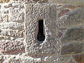
Keyhole notch

Muzzle

Round tower Bahnhofstrasse

Madonna figure
.JPG)


Oddities
Until 1850, Spessartstrasse ended in the east with no passage at the wall. Around 1865, however, a hole in the wall has been handed down that allowed a person to slip through. This hole was used to get to the Gasthaus Zum Engel on the inside of the wall without much detour . In popular parlance, the connection between the hole and the inn was so closely linked that the name Loch had become natural for the inn, without containing a negative rating.
Restoration and award

During the restoration from 2012 to 2015, the remaining areas of the fortifications were preserved in their respective structural condition, but modern repair attempts and changes were removed. The height of the wall corresponds to the state before the restoration. In order to prevent water from penetrating the wall, the upper area was sealed inside with asphalt and the wall crown cover was completed with new sandstones in a slightly rounded shape. The new technology developed by the Bavarian State Office for Monument Preservation in Thierhaupten prevents the ingress of water, but at the same time allows a certain flexibility and thus prevents the formation of cracks.
On the west tower of the north gate, the pedestrian opening that had been broken through in the 1960s was closed. In the area of the towers, the base was exposed in order to get an impression of the original height of the tower and walls before the ground level in the area was raised.
Large, lavishly restored areas of the town wall still exist in the north and east. In the south, to the right and left of the former Upper Gate, a total of around 100 meters long section of the fortification has been preserved. Due to the expansion of the place, increasing industrialization and changes in traffic conditions, more and more wall demolitions were made from the end of the 19th century. In particular, the walls in the west (parallel to Hinteren Dorfstraße) and in the area of St. Margaret's Church were demolished. The original course of the wall was marked in many places by a special paving with rubble stones when the pavement was built.
The exemplary renovation of the wall system was awarded the Sparkasse Building Prize 2014 from the non-profit foundation of Sparkasse Miltenberg-Obernburg . The official inauguration of the facility and the display boards took place on June 24, 2016, while the actual festival with guided tours took place on June 25.
literature
- Thomas Biller : The medieval city fortifications. A manual. 2. Topographical part. von Zabern, Darmstadt 2016, ISBN 978-3-8053-4975-8 , p. 120.
- Susanna Rizzo: Historic towers, gates, walls and paths - the fortifications in Sulzbach am Main (not yet published)
- Historical map of Sulzbach am Main, 1849 on www.bayerische-landesbibliothek-online.de
Web links
- Susanna Rizzo: Compendium "Historic Towers, Gates, Walls and Paths". (PDF, 3.3 MB) Markt Sulzbach am Main, 2016, accessed on February 18, 2016 (summary).
- Bavaria Atlas - Historical map of Sulzbach am Main. Bavarian State Ministry of Finance, for Regional Development and Homeland, 1845, accessed on February 20, 2016 (colored first recordings - assembly of the four frame floor sheets NW 86-75.ad).
Individual evidence
- ↑ Information board for the fortifications in Sulzbach am Main (Station 1)
- ↑ List of monuments for Sulzbach am Main (PDF) at the Bavarian State Office for Monument Preservation
- ↑ a b c d e f Main-Echo: Historical walls, towers and gates , home history: time travel with archaeologist Susanna Rizzo through five centuries of Sulzbach local history, accessed on October 1, 2015
- ↑ a b c Notice board for the fortifications in Sulzbach am Main (Station 5)
- ↑ a b c Display board for the fortifications in Sulzbach am Main (Station 2)
- ↑ a b Display board for the fortifications in Sulzbach am Main (station 7)
- ↑ Site plan from 1849 (Bruoillon to NW LXXXVI. 75 abcd)
- ↑ a b c Display board for the fortifications in Sulzbach am Main (station 6)
- ↑ Display board for the fortifications in Sulzbach am Main (station 4)
- ↑ a b Display board for the fortifications in Sulzbach am Main (Station 3)
- ↑ a b Susanna Rizzo: Compendium "Historical Towers, Gates, Walls and Paths". (PDF; 3.3 MB) Markt Sulzbach am Main, 2016, accessed on February 18, 2016 (summary).
- ↑ Information board for the fortifications in Sulzbach am Main (station 8)
- ↑ Sparkassen-Stiftung awards building prize. (No longer available online.) Miltenberg district, March 13, 2015, formerly in the original ; accessed on February 20, 2016 : “Brandl described the repair of the Sulzbach town wall, its didactic preparation and the associated lighting concept as“ exemplary ”. In some places the wall was even restored to its original height. With this, the community of Sulzbach will get the wall and arouse interest in local history, says Brandl. "
- ↑ "The fortification has been repaired!" - Warm invitation. Market Sulzbach am Main, accessed on June 22, 2016 .
Coordinates: 49 ° 54 ′ 34 " N , 9 ° 9 ′ 11.4" E