Ottmaring (Dietfurt an der Altmühl)
|
Ottmaring
Community Dietfurt an der Altmühl
Coordinates: 49 ° 2 ′ 9 ″ N , 11 ° 32 ′ 33 ″ E
|
|
|---|---|
| Height : | 377 m above sea level NN |
| Residents : | 161 (2007) |
| Incorporation : | July 1, 1972 |
| Postal code : | 92345 |
| Area code : | 08464 |
|
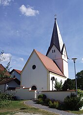
Ottmaring, view from the north
|
|
Ottmaring is a district of Dietfurt an der Altmühl in the Neumarkt district in Upper Palatinate in Bavaria .
Geographical location
The church village with about 160 inhabitants is located in the Ottmaringer Valley , named after him , which extends north of the Altmühltal from Beilngries to the Dietfurt Basin, at about 377 m above sea level .
history
The place was created during the conquest of land by the Bavarians (6th – 9th centuries). The place name should not go back to the church patron St. Ottmar, but to a Germanic clan head named Otmar or Audmer. In the course of the Hirschberg inheritance of 1305, “Ottmaëringen” came from the property of the last Count of Hirschberg , Gebhard VII., To the Eichstätt Monastery . At that time, a Liebhard von Ottmaring was an imperial vice chairman .
The medieval Ottmaring was characterized by an early Gothic church and two country nobility seats, a smaller one in the west of the village and the "Ottmaringer Castle" as the larger complex in the south. Its noble owners were 1496-1644 as feudal ministers of the Eichstätter bishop. The two aristocratic seats have gone; only the foundation walls of the smaller one have been preserved, while the remains of the once towering southern castle had to give way to the construction of the RMD Canal . Some of the tombstones of the former landed gentry are set into the cemetery wall.
After secularization , Ottmaring came to the then district office in 1804 and later to the district of Beilngries . When this was dissolved during the regional reform, Ottmaring joined the city of Dietfurt an der Altmühl on July 1, 1972 and has since been part of the Neumarkt district in the Upper Palatinate .
The Mühlbach, on which the village was originally located, merged in 1830 in the Ludwig-Danube-Main Canal , which ran through the Ottmaringer Valley. The construction of the RMD Canal in 1976 through the Ottmaringer Valley was very controversial with regard to the conservation of the species-rich valley. In the 19th century, peat was extracted in the Ottmaringer Valley (Ottmaringer Moos) .
Culture and sights
Buildings
As a small choir tower church, the Catholic branch church St. Ottmar has a medieval tower and a baroque nave . The tower with a pointed spire over four gables dates from the 13th or 14th century, but was not completed until the 18th century. The first church was changed somewhat in 1516; Wall paintings from this period depicting the Last Supper , the Passion and Resurrection of Jesus Christ were rediscovered during a renovation in 1921. In 1854 the nave was extended to the west and a curved gallery was added. The baroque high altar painting from 1756 shows the church patron as abbot of St. Gallen , to whom the sick come and ask for healing. The late Gothic side figures represent St. Martin on the left and St. Nicholas on the right . The side altars that were removed in 1960 were returned to the church in 1987 after a renovation; the left altar panel shows a crescent Madonna , the right one shows Saint Joseph , both in Nazarene style . Several late Gothic, high and late baroque figures decorate the nave.
Two gravestones set into the cemetery wall commemorate Euphrosine von Donneck, who died after 1600, wife of the Hirschberg caretaker Ferdinand von Donneck, who acquired the lower Ottmaringer castle in 1592, and Joachim Rieter von Kornburg zu Ottmaring, main carer at the Willibaldsburg Eichstätt, who lived in 1619 in Ottmaring has died; In addition to his personal coat of arms, the stone shows the insignia of the Order of the Swords of Aragon and the Order of the Holy Sepulcher in Jerusalem .
In the Middle Ages the village belonged to the original parish of Kottingwörth . From 1483 to 1611 Ottmaring was an independent parish, after which it became a branch of the Töging parish .
traffic
A bridge crosses the RMD Canal near Ottmaring, so that the place can be reached from the Beilngries - Töging road. From Dietfurt there is also a road to Ottmaring. There are cycle paths on both sides of the RMD Canal.
literature
- Felix Mader (editor): The art monuments of Upper Palatinate & Regensburg. XII District Office Beilngries. 1928 (Reprint 1982, ISBN 3-486-50442-8 .) P. 112f.
- Ottmaringer Valley . In: Hubert Weiger (Hg): The Rhine-Main-Danube Canal. Munich: Claus Schulz Verlag 1983, pp. 132-134.
- August Schönhuber, Johann Grad, Ferdinand Albrecht and others (editors / editor): place and home chronicle of Töging and Ottmaring . Töging 1990


