
Poetting
|
Poetting
|
||
|---|---|---|
| coat of arms | Austria map | |
 |
|
|
| Basic data | ||
| Country: | Austria | |
| State : | Upper Austria | |
| Political District : | Grieskirchen | |
| License plate : | GR | |
| Surface: | 7.43 km² | |
| Coordinates : | 48 ° 17 ' N , 13 ° 46' E | |
| Height : | 381 m above sea level A. | |
| Residents : | 531 (January 1, 2020) | |
| Postal code : | 4720 | |
| Area code : | 07733 | |
| Community code : | 4 08 20 | |
| NUTS region | AT311 | |
| Address of the municipal administration: |
Pötting 55 4720 Pötting |
|
| Website: | ||
| politics | ||
| Mayor : | Peter Oberlehner ( ÖVP ) | |
|
Municipal Council : (2015) (13 members) |
||
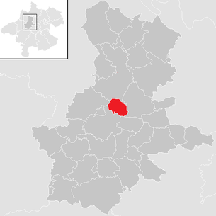
| Location of Pötting in the Grieskirchen district | ||
  |
||
| Source: Municipal data from Statistics Austria | ||

Pötting is a municipality in Upper Austria in the Grieskirchen district in the Hausruckviertel with 531 inhabitants (as of January 1, 2020). The community is located in the judicial district of Grieskirchen .
geography
Pötting is 381 m above sea level in the Hausruckviertel. The extension is 6.5 km from north to south and 3.2 km from west to east. The total area is 7.43 km², about 5% of the area is forested, 84% of the area is used for agriculture.
Community structure
The municipality comprises twelve localities (population in brackets as of January 1, 2020):
- Albrechtsberg (31)
- Dürrnaschach (10)
- Kronlach (13)
- Moss (28)
- Oberaschach (41)
- Obernfurth (62)
- Poetting (240)
- Hull endopl (9)
- Spielmannsberg (22)
- Strasshof (5)
- Sumeding (51)
- Unterfürth (19)
The community consists of two cadastral communities (area 2016):
- Pötting (393.99 ha)
- Spielmannsberg (349.37 ha)
Neighboring communities
| Peuerbach | ||
| Kallham |
.svg)
|
Michaelnbach |
| Taufkirchen an der Trattnach | Great |
Population development
In 1991 the community had 504 inhabitants, by 2001 the number of inhabitants rose to 539. From 2001 to 2011 the positive birth balance (+33) and the negative migration balance (-32) almost offset each other , so that the population remained almost constant at 540.
coat of arms
Blazon :
- “In green, a silver, sloping left, lowered wavy bar; above a golden, straight-armed paw high cross, below a golden will-o'-the-wisp. "
The community colors are green-yellow-black.
The municipal coat of arms was awarded in 1992. The cross stands for the ecclesiastical patronage of the exaltation of the cross , the will- o'- the- wisps recalls the legend of the “Lichtl in der Au”, the restless soul of a criminal who drowned in a pond while on the run, waiting for redemption. The wavy bar symbolizes the Aschach drought flowing through the municipality .
history
Originally located in the eastern part of the Duchy of Bavaria, the place belonged to the Duchy of Austria since the 12th century. Since 1490 it has been assigned to the Principality of Austria ob der Enns . During the Napoleonic Wars , the place was occupied several times. Since 1918 the place belongs to the federal state of Upper Austria. After the annexation of Austria to the German Reich on March 13, 1938, the place belonged to the Gau Oberdonau. In 1945 Upper Austria was restored.
politics
- mayor
- since 1997 Peter Oberlehner (ÖVP)
Culture and sights
- Parish church Pötting : The Gothic hall church makes a high and wide spatial impression.
Personalities
- Franz Eiblhuber (1891–1950), priest, educator and politician
Web links
- 40820 - Pötting. Community data, Statistics Austria .
- Further information about the municipality of Pötting can be found on the geographic information system of the federal state of Upper Austria .
- www.poetting.ooe.gv.at Website of the municipality
Individual evidence
- ↑ Statistics Austria: Population on January 1st, 2020 by locality (area status on January 1st, 2020) , ( CSV )
- ↑ Federal Office for Metrology and Surveying, Regional Information, reference date December 31, 2016, accessed on February 19, 2017
- ^ Statistics Austria, A look at the community of Pötting, population development. Retrieved April 13, 2019 .
- ^ Herbert Erich Baumert: The coats of arms of the cities, markets and communities of Upper Austria, 9th (last) supplement 1992-1996. In: Oberösterreichische Heimatblätter, Heft 3, 1996, p. 247 f, online (PDF) in the forum OoeGeschichte.at
- ^ Province of Upper Austria, results of the 2015 elections. Retrieved on April 13, 2019 .

Aistersheim | Bad Schallerbach | Eschenau im Hausruckkreis | Gallspach | Gaspoltshofen | Geboltskirchen | Grieskirchen | Haag am Hausruck | Heiligenberg | Hofkirchen an der Trattnach | Kallham | Kematen am Innbach | Meggenhofen | Michaelnbach | Natternbach | Neukirchen am Walde | Neumarkt im Hausruckkreis | Peuerbach | Pollham | Pötting | Pram | Rottenbach | St. Agatha | St. Georgen near Grieskirchen | St. Thomas | Schlüßlberg | Steegen | Taufkirchen an der Trattnach | Great | Waizenkirchen | Wallern an der Trattnach | Women | Wendling