
Pachmarhi
| Pachmarhi Hindi पचमढ़ी |
|||
|---|---|---|---|
|
|||
| State : |
|
||
| State : | Madhya Pradesh | ||
| District : | Hoshangabad | ||
| Sub-district : | Pipariya | ||
| Location : | 22 ° 29 ′ N , 78 ° 26 ′ E | ||
| Height : | 1065 m | ||
| Area : | 10 km² | ||
| Residents : | 12,062 (2011) | ||
| Population density : | 1206 inhabitants / km² | ||
 |
|||

Pachmarhi ( Hindi : पचमढ़ी ) is a small town with about 12,000 inhabitants in the district of Hoshangabad in the Indian state of Madhya Pradesh . Pachmarhi was a hill station in the Pachmarhi Cantonment during British colonial times .
Location and climate

Pachmarhi is located in an average 1065 m high valley basin of the Satpura Mountains in the middle of the Satpura National Park, almost 200 km (driving distance) southeast of the megacity of Bhopal and is also known as Satpura ki Rani ("Queen of Satpura"). The highest point of the mountain is the Dhupgarh or Dhoop Garh at 1352 m above sea level . At the foot of this mountain there is a seldom used field airfield, next to which the Indian army has a training camp. The district capital Hoshangabad is about 120 km northwest of Pachmarhi.
The climate is generally temperate to mild; Rain (approx. 2010 mm / year) falls almost exclusively during the summer monsoon season . The place and its wooded surroundings have been designated as a Pachmarhi Biosphere Reserve by Unesco since May 2009 . Tigers and leopards have already been observed here, and species-rich flora has also settled. Several small waterfalls (Bee Falls and Silver Falls) form a tourist highlight.
economy
The region is traditionally agriculturally oriented. Since the end of the 20th century, tourism (mainly summer) has also played an important role in the economic life of the wooded and rugged region.
Naming and history
The name of the place is traced back to the Pandava brothers and the corresponding Hindi words who are said to have lived here in five (panch) (marhi) (caves) during their thirteen-year exile . In the Middle Ages the area belonged to the Gond's sphere of influence . In 1857 the high valley was discovered by a British army group; afterwards it quickly developed into an exclusive hill station with a sanatorium.
The city and its population
The small town in terms of area is relatively densely populated with 1200 people per square kilometer. It and its surroundings are under the military administration of the Pachmarhi Cantonment Board of the Indian Army. About 85 percent of the population are Hindus and about 11 percent Muslim ; the rest is attributable to other religious communities such as the Jains , Sikhs , Christians , Buddhists . The most common language is Hindi . The proportion of the male population is around 40 percent higher than the female population, which is mainly due to the large number of male seasonal workers .
Attractions
Here is a selection of interesting buildings and sights:
The Annunciation 's Church (Church of the Annunciation) in place is an Anglican parish church from the year 1892nd
The Pandava Caves , about one kilometer south of the village, form a group of several Buddhist cave temples from the 5th / 6th centuries. Century. Even further south, about seven kilometers by car, is Chauragarh Hill , on the summit of which there is a modern Shiva temple. Right next to it is a compilation of several hundred - brought along by pilgrims - trishula - votive offerings .
Some rock paintings are located around five kilometers northeast of the village and can be viewed.
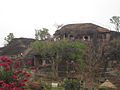
Pandava Caves

Jatashankar Temple

trishulas at Chauragarh Temple

Shiva statue
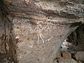
Rock painting


literature
- Swati Mitra (Ed.): Pachmarhi Travel Guide: Includes Bhopal, Bhimetka and Jabalpur . Eicher Goodearth Publications, New Delhi 2009, ISBN 978-81-87780-95-3 , pp. 6 (English, limited preview in Google Book Search).
Web links
Individual evidence
- ↑ Pachmarhi - data + facts
- ↑ Pachmarhi - climate tables
- ↑ Pachmarhi Story , accessed November 2018.
- ^ Pachmarhi - Population , accessed November 2018.
- ↑ Pachmarhi and surroundings - map with sights
- ↑ Pachmarhi and surroundings - sights