
Paramaribo
| Paramaribo | ||
|---|---|---|
|
Coordinates: 5 ° 49 ′ N , 55 ° 10 ′ W Paramaribo on the map of Suriname
|
||
| Basic data | ||
| Country | Suriname | |
| District | Paramaribo | |
| Residents | 240,924 ( 2012 Census ) | |
| Detailed data | ||
| surface | 182 km 2 | |
| Population density | 1323.8 inhabitants / km 2 | |
| height | 3 m | |
| City structure | 12 departments | |
| Waters | Suriname (river) | |
| prefix | +597 | |
| Time zone | UTC −3 | |
 |
||

Paramaribo (ˌpaːraːˈmaːriboː) is the capital and one of ten districts of the Republic of Suriname in South America. The 2012 census found 240,924 residents, which is almost half of the country's total population.
geography
The city is located on the left bank of the Suriname River , about 23 km upstream from the Atlantic Ocean .
history
The name Paramaribo is probably derived from a Caribbean village , Parmirbo . In 1613 the two Dutchmen Dirck Claeszoon van Sanen and Nicolaas Baliestel founded a small trading company near Parmirbo on the west bank of Suriname . To protect against attacks by Caribs, the post was surrounded by palisades.
After several failed attempts by Europeans to gain a permanent foothold, the post fell into English hands in 1651. The English converted the post into a fort, the Fort Willoughby, on behalf of Francis Willoughby. However, they settled further south, about 50 km from the fort, on the Suriname River. The English founded the city of Torarica here as the center of the newly occupied area .
In 1667 the area was conquered for the Zeeland people under Abraham Crijnssen . The fort was now named Fort Zeelandia and the place Paramaribo was renamed New Middelburg for a short time. This made the fort the center of the colony. From the fort, the city expanded first in a western and then in a southern direction. Nevertheless, in 1683 the city itself consisted only of a collection of 27 buildings. Only from the year 1790 there are reports of the counting of more than 1000 buildings.
The city was partially destroyed in two major fires in 1821 and 1832.
After slavery was abolished in 1863 and the subsequent ten-year obligation to work in 1873 (Staatstoezicht) , many ex-slaves moved to the city. This made the first major city expansion necessary. After 1950, due to the increase in the population, there were further major urban construction projects. In 1987 Suriname underwent a regional reform and administrative restructuring. The Paramaribo district was divided into twelve departments.
According to the results of the housing and population census in 2012, the population of Paramaribo decreased slightly compared to the previous census in 2004.
Architecture and population
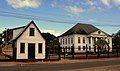
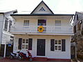
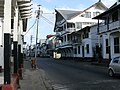
The architecture of Paramaribo predominantly mixes Dutch, French and later also American influences, which are closely related to historical developments. As a result, Paramaribo developed a style in which mainly wood and less bricks were used. The multi-ethnic and multi-religious population is also reflected in the multitude of different and differently designed religious buildings, such as churches, synagogues, mosques and temples.
Since July 2002, the historic center of Paramaribo has been on the UNESCO World Heritage List .
- Paramaribo Gallery

Presidential Palace on Onafhankelijkheidsplein

Church of the Moravian Brethren in Steenbakkerijstraat, built in 1847

Roman Catholic Cathedral of St. Peter and Paul , built in wood in 1883, in the Henck Arronstraat
Synagogue (1842) Keizerstraat

Hindu temple (Arya Dewaker ca.1998) Wanicastraat

Monument on Kleine Combeweg in honor of the immigrants, see also Hindustanen
Former German honorary consulate on Costerstraat
New German Honorary Consulate in the Dr. Sophie Redmondstraat 250

Honorary Consulate of Austria at Henck Arronstraat 16

Historical buildings Swalmbergstraat
Lim A Postraat
Helstone monument

Lachmon statue, Independence Square
Pengel Statue, Independence Square

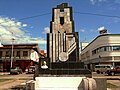
Parliament building , in front of it ...

... the national anthem carved in stone

Secretariat of the football association SVB

At the André Kamperveen Stadium

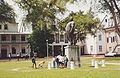
Fort Zeelandia courtyard
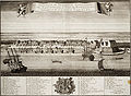
Historical map of Paramaribo


Economy and Transport
Paramaribo is the country's most important port, from here the country's products are shipped overseas. The small Zorg en Hoop airport is primarily used to transport people and goods into the impassable inland.
Town twinning
sons and daughters of the town
Web links
- Outline map of Paramaribo (Dutch)
- Entry on the UNESCO World Heritage Center website ( English and French ).
Individual evidence

Heritage: Historic Downtown Paramaribo (2002)
Natural Heritage: Central Suriname Nature Reserve (2000)