
Passo San Antonio
| Passo San Antonio | |||
|---|---|---|---|
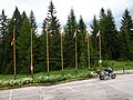
.jpg) Passo San Antonio View of the inn in north direction. |
|||
| Compass direction | North | south | |
| Pass height | 1489 m slm | ||
| province | Belluno ( Veneto region ) | ||
| Watershed | Pàdola → Piave | Ansiei → Piave | |
| Valley locations | Pàdola | Sta. Caterina, Auronzo di Cadore | |
| expansion | Strada Provinciale 532 | ||
| Winter closure | November to March | ||
| Mountains | Sexten Dolomites | ||
| map | |||
|
|||
| Coordinates | 46 ° 33 '26 " N , 12 ° 29' 1" E | ||

The Passo San Antonio ( 1489 m ) is located south of the Carnic Alps, southeast of the Kreuzberg Pass on the Italian federal road SS532 . Valley locations are Pàdola in Val Pàdola in the north and Sta. Caterina in the south. The route is 17 km long, with a height difference of 614 m. Winter closure from November to March. The pass is not very frequented and therefore cannot be found on all road maps.
There is also an Italian pass of the same name on the SP8 east of Lake Maggiore . It leads from Vararo in a north-easterly direction and then branches off to Arcumggia or Ponticello. The pass is very narrow (lane width less than 3 m).
gallery

Passo San Antonio view in south direction.

Passo San Antonio Tavern on the top of the pass.
Passo San Antonio car park from the inn on the top of the pass.
.jpg)
.jpg)
.jpg)
Web links
Agnello • Aprica • Assietta • Aurine • Borcola • Bordala • Brennero / Brenner • Brocon • Cadibona • Campo Carlo Magno • Campolongo • Camporosso (Saifnitzer) • Carnizza • Castrin / Hofmahd • Cereda • Ciampigotto • Cibiana • Cimabanche • Coe • Colombardo • Croce d'Aune • Croce Domini • Crocette • Costalunga / Karer • Duran • Eira • Eores / Kofel • Esischie • Erbe / Würz • Falzarego • Fauniera • Fedaia • Finero • Finestre • Foppa • Foscagno • Furcia / Furkel • Fusine (Ratschacher ) • Gavia • Gardena / Grödner • Giau • Gola / Klamml • Gran San Bernardo • Kreit • Lavazè • Livigno • Lombarda • Lúsia • Lys • Maddalena • Manghen • Mauria • Mendola / Mendel • Mont Rest • Monte Croce / Plöcken • Monte Croce di Comélico / Kreuzberg • Monte Giovo / Jaufen • Mortirolo • Nevea • Nigra / Niger • Palade / Gampen • Pampeago / Pale / Reiter • Pénnes / Penser • Pian delle Fugazze • Piccolo San Bernardo • Pordoi • Pramollo (Nassfeld) • Predil • Resia / Reschen • Rolle • Russis • Rombo / Timmel • Sampeyre • San Antonio • San Boldo • San Giovanni • San Lugano • San Marco • San Pellegrino • Santa Maria (Umbrail) • Sella • Sestriere • Sommo • Spluga (Splügen) • Stalle / Staller • Staulanza • Stelvio / Stilfser • Tanamea • Tenda • Tonale • Tre Croci • Tremalzo • Valles • Valcavera • Valparola • Vezzena • Vivione • Zovo