
Pitlochry
|
Pitlochry Scottish Gaelic Baile Chloichridh |
|||
|---|---|---|---|
| Coordinates | 56 ° 42 ′ N , 3 ° 44 ′ W | ||
|
|||
| Residents | 2776 2011 census | ||
| administration | |||
| Post town | PITLOCHRY | ||
| ZIP code section | PH16 | ||
| prefix | 01796 | ||
| Part of the country | Scotland | ||
| Council area | Perth and Kinross | ||
| British Parliament | Perth and North Perthshire | ||
| Scottish Parliament | Perthshire North | ||

Pitlochry ( Gaelic Baile Chloichridh, also Baile Chloichrigh; German about the place of the stone square ) is a parish ( Burgh ) in Perthshire , Scotland , with 2776 inhabitants, located on the River Tummel . Today, Pitlochry is essentially a tourist destination and welcomes its guests with the Gaelic greeting on the outskirts of the town "Ceud mìle fàilte" - 100,000 welcome ".
history
In the nearby Allean Forest there are the remains of an 8th century ring fort called "The Black Spout".
The historical origins of Pitlochry go back to the year 208 AD, when the Roman Emperor Septimius Severus pushed forward to the Moray Firth and built forts to protect the troops in the side valleys . The Picts erected a symbol stone ( Dunfallandy Stone ) in the originally independent place that was created there later, whose church, Moulin Kirk, is mentioned as early as 1180. In 1511 Moulin was named Burgh.
The place Pitlochry itself was created after General George Wade had a road built through the place from 1725 to open up the rural areas of Scotland after the Jacobite uprisings of 1715. In 1842 Queen Victoria visited the nearby Blair Castle . This increased the popularity of the place.
A train station was established in 1863 and Pitlochry became a popular tourist destination. Subsequently, the Atholl Palace Hotel emerged as a landmark of the area that still exists today. In 1947 Pitlochry was named a district (Burgh). In the same year, the construction of a dam to generate energy from hydropower began. The dam dams the Tummel River to Loch Faskally and has a 311 m long salmon ladder . Loch Faskally and the fish ladder are some of the most popular tourist attractions. In 1951 the Pitlochry Festival Theater was opened, which originally played in a tent. The current theater building dates from 1981.
The place was a 2003 winner of the “Britain in Bloom” horticultural competition in the Small Country Town category .
In addition to the theater and the hydroelectric power station, Pitlochry now has two whiskey distilleries ( Edradour (outside) and Blair Athol (on the main street)) and a microbrewery.
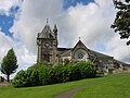
Pitlochry Church of Scotland and Tryst
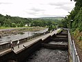
Fish ladder in Pitlochry

Pitlochry train station


traffic
The A9 ( Inverness - Perth ) run through Pitlochry . The village has had Pitlochry station since 1863 , which is served by trains on the Highland Main Line and the Caledonian Sleeper .
Individual evidence
- ^ Pitlochry - Gaelic Place Names of Scotland. Retrieved November 23, 2019 .
- ↑ Iain Mac Tailleir: Place-names. (PDF) In: Scottish Parliament. P. 95 , accessed on November 23, 2019 (English).
- ↑ 2011 census