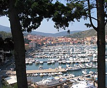
Porto Ercole
Porto Ercole is the smaller of the two places on the Monte Argentario peninsula on the southern edge of Tuscany . Together with Porto Santo Stefano it forms the municipality of Monte Argentario .
The municipality is a member of the association I borghi più belli d'Italia (The Most Beautiful Places in Italy).
history
The Roman history of Monte Argentario under the influence of the Domitii Ahenobarbi family is well documented.
In the Middle Ages, the small base changed hands with the entire mountain range several times: after the Aldobrandeschi (13th century), the Orsini (14th century) and Ladislaus of Naples (1410–1414), it finally fell to Siena .
In 1555, the Sienese Porto Ercole was the scene of stubborn resistance in the alliance with the French against the Spanish Habsburgs under King Philip II in alliance with Cosimo I de 'Medici of Florence. After a long siege by the Milanese Marchese di Marignano , an older brother of Pope Pius IV , by land and by Admiral Andrea Doria , Porto Ercole fell in June and was included in the Treaty of Brussels together with Porto Santo Stefano , Orbetello , Ansedonia , Talamone and Porto Longone combined to form the Spanish garrison state Stato dei Presidi . This integrated those Sienese possessions that Siena's conqueror Cosimo I de 'Medici was not allowed to keep for his Grand Duchy of Tuscany .
After that, Porto Ercole shared the fate of the Spanish garrison state, which the Austrians conquered in 1707. Porto Ercole resisted but was forced to join on March 22, 1712. In 1737 the Stato dei Presidi came under the rule of the Bourbons , and in 1801 Napoleon captured it in his Etrurian Republic . After its fall in the Congress of Vienna in 1815, the territory came to the Grand Duchy of Tuscany and in 1860 to the Italian nation-state.
Attractions
- The main attraction of the place are the massive fortresses Filippo , Santa Caterina, Stella and La Rocca, which were built under the Spanish administration of the garrison state in the 16th century. Filippo is the oldest part, named after his client, King Philip II. Fortress builder Giovanni Camerini built four bastions, surrounded by a moat, with access via a drawbridge. The powder magazine and other ammunition depots were located in the basement. The Santa Caterina battery, located a little below on the same hill, housed the artillery. La Rocca was later built on another hill. Inside there is a citadel divided into small inner courtyards , which is connected to the Santa Barbara Battery by a gallery. Forte Stella takes its name from its star-shaped floor plan. There are numerous loopholes for artillery on both the land and the sea side. This fort was also accessible via a drawbridge. The fortifications are now privately owned and are not open to the public.
- The Palazzo Cansani in the Piazzetta di Santa Barbara was built in 1508, but was destroyed by an attack by corsairs led by Cheir ed-Din Barbarossa . The Spaniards rebuilt it and used it as the seat of government of the Stato dei Presidi.
- The small old town with a borgo character (stairways) still has a number of original archways from the time when Siena was independent.
- Michelangelo Merisi da Caravaggio (1571–1610) is buried in the parish church of Sant'Erasmo .
- A promenade with shops, cafés and fish restaurants, which is lively in summer, runs along the marina. Many of these facilities are closed out of season.
Tombolo di Feniglia
To the north-east of the village, an approximately 6 km long sandy beach stretches along the so-called Orbetello lagoon to the southern of the three headlands.
Caravaggio was found dead on July 18, 1610 at this lagoon, which in the 17th century was still largely surrounded by the malaria-infested swamps of the Maremma . It is unclear whether he died of malaria or of the consequences of an injury sustained during an argument in Naples a year earlier. Caravaggio had found himself on the run to Rome because his opponents were trying to kill him.
Today, lively bathing and camping areas are characteristic of the beaches immediately east of Porto Ercole. On the spit, which is not passable by car, there are pine forests, through which bike and hiking trails lead. It has been reported that fallow deer and sometimes even wild boar can be seen frequently.
economy
The main source of income is tourism. Numerous hotels and apartment complexes, occasionally also agrotourism , are geared towards longer holiday stays for guests; In addition, more day-trippers come by during the main season. Upscale fish gastronomy dominates the harbor.
Web links
- The Monte Argentario Almanac in German: nature, culture, history, politics, tourism, sport, events
- Almanaco del Monte Argentario in italiano: informazioni approfondite sul Monte Argentario
- Portal Porto Ercole
Individual evidence
- ^ I borghi più belli d'Italia. Borghipiubelliditalia.it, accessed August 6, 2017 (Italian).
Coordinates: 42 ° 24 ' N , 11 ° 12' E


