Queenstown (Tasmania)
| Queenstown | |||||||
|---|---|---|---|---|---|---|---|
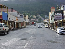
 Orr Street (view from the west) |
|||||||
|
|||||||
|
|||||||
|
|||||||
|
|||||||
|
|
|||||||
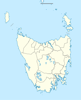
Queenstown is a city in the west of the Australian state of Tasmania . It is located in a valley west of Mount Owen in the West Coast Range .
At the 2016 census, the city had 1,755 inhabitants, whereas in 2011 the city still had 1975 inhabitants. Five years earlier it was again 2117.
history
For a long time Queenstown's history was shaped by mining. The mountainous area was first explored in 1862. It was not until much later that alluvial gold was found at Mount Lyell , which led to the establishment of the Mount Lyell Gold Mining Company in 1881 . From 1892 onwards, copper was also mined in the mine. Eventually the mining company was renamed the Mount Lyell Mining and Railway Company .
In the early years of the 20th century, Queenstown was the center of the Mount Lyell mining district and owned many smelters, brickworks and sawmills. The area was then lushly forested. Around 1900 there were 5051 inhabitants in the city and 10,541 in the entire administrative district.
The authorities of the administrative district of the same name were located in Queenstown until it was merged with the other administrative districts of the west coast in the 1990s. In its prime there were a number of hotels, churches, and schools in the city, but their numbers have decreased significantly since the mining company closed.
The city was also home to the Organization for Tasmanian Development , which was founded in 1982.
The construction of several dams nearby by Hydro Tasmania led to a brief boom in Queenstown in the 1980s. The Darwin Dam and Crotty Dam , which created Lake Burbury - a popular spot for sport fishing and other recreational activities - were built during this period. They were created after the Franklin Dam project was canceled in 1983 following the campaign of active environmentalists.
Queenstown is experiencing a revival today, which was evident in the popularity of its Arts and Heritage Festival , first held in 2010 . The city has recently become a small but prosperous society of artists, composed of writers, painters, photographers and historians who are inspired by the unique beauty and history of Queenstown.
The recently rebuilt cog railway (System Abt ) and the new mining and research activities in the region have also contributed to the rejuvenation of the city in recent years.
ecology
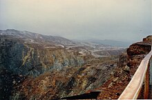
The mountains around Queenstown show unusual pink and gray colors, which come from the sedimentary rock on the two mountains in the immediate vicinity - Mount Lyell and Mounr Owen. In winter, the mountain peaks around Queenstown are often covered with snow. In the city itself it only snows a few days a year.
A combination of logging to fire the furnace (around 40 years) and heavy annual rainfall led to the erosion of the flat layers of the earth over many decades, so that the harder rocks came to light.
Typical of the vegetation that developed after the forest fires in western Tasmania on the affected areas along the creeks on the slope is the low scrub, which represents a first step on the long road to restoring the ecology of this region.
Some residents of this area suggested in the 1980s that the low brushwood could spoil the appearance of a rigid “lunar surface” typical of the southern slopes of Mount Lyell and the northern slopes of Mount Owen. Although there are large areas on which, due to their steepness and the lack of soil, no new vegetation will form, the mythology of the formation of these areas will prove to be partially untrue due to the degree of recovery of the plant cover over time.
The Queen River had to take in its sewage from Queenstown for most of the Mount Lyell Company's existence, which was then diverted into the King River and eventually into Macquarie Harbor .
The Mount Lyell Remediation and Research and Demonstration Program has ensured that wastewater from mining and the city is no longer discharged directly into the receiving waters .
Current condition

Today, the city and its surroundings attract large numbers of tourists who come either on organized tours or by rental car. She must be dressed in something - either the mountains, the spoil heap or the football cinder pit ... There are plenty of opportunities to glimpse the city's past at the local museum, but also just walking down Orr Street , the down the old main street with its closed pubs and the dominant tower of the post office, there is a lot to discover.
Mining in the old mine on Mount Lyell continues. It became independent from the Copper Mines of Tasmania in 1995–1999 , which was then integrated into an Indian group of companies, so that the concentrates are now shipped to India for further processing.
Exploitable ore deposits are still being sought in the region. Because of the complex geology, there is always the possibility that new mines will be excavated. The Henty Gold Mine , which opened in the 1990s, is a good example of this.
Queenstown is the destination of the West Coast Wilderness Railway , which runs south along the Queen River and then along the north bank of the King River to Strahan at Macquarie Harbor.
panorama
climate
| Queenstown (Tasmania) | ||||||||||||||||||||||||||||||||||||||||||||||||
|---|---|---|---|---|---|---|---|---|---|---|---|---|---|---|---|---|---|---|---|---|---|---|---|---|---|---|---|---|---|---|---|---|---|---|---|---|---|---|---|---|---|---|---|---|---|---|---|---|
| Climate diagram | ||||||||||||||||||||||||||||||||||||||||||||||||
| ||||||||||||||||||||||||||||||||||||||||||||||||
|
Average monthly temperatures and rainfall for Queenstown, Tasmania
Source: Australian Bureau of Meteorology : QUEENSTOWN (7XS) Station. Observation period: 1965–1995. Retrieved November 24, 2016.
|
|||||||||||||||||||||||||||||||||||||||||||||||||||||||||||||||||||||||||||
literature
- Blainey, Geoffrey: The Peaks of Lyell , 6th Edition. Edition, St. David's Park Publishing, Hobart 2000, ISBN 0-7246-2265-9 .
- P. Davies, N. Mitchell and L. Barmuta: The impact of historical mining operations at Mount Lyell on the water quality and biological health of the King and Queen River catchments, western Tasmania . Mount Lyell Remediation Research and Demonstration Program. Supervising Scientist Report 118, Supervising Scientist, Canberra (1996). ISBN 0-642-24317-4
- B. & LA Gardiner: In shadow of Lyell . Devonport TAS (1983). ISBN 0-9592424-2-2 :
- Charles Whitham: Western Tasmania - A land of riches and beauty , Reprint 2003. Edition, Municipality of Queenstown, Queenstown.
Web links
- Photos of the furnaces on Mount Lyell. State Library of Tasmania. * Photo collection
- Information about the hotels on the main road (English)
- Website with information about Queenstown (English)
- Janine Mansson's ABC Collectors Review
Individual evidence
- ↑ Bonzle: Map of Queenstown in Tasmania . Retrieved November 24, 2016.
- ^ Geoscience Australia : Elevation Information System (ELVIS) . Zoom in on Queenstown and use the Elevation Cross Section Tool to draw a very short distance on the street at the train station. Retrieved November 25, 2016.
- ↑ a b Australian Bureau of Statistics : Queenstown ( English ) In: 2016 Census QuickStats . June 27, 2017. Retrieved April 3, 2020.
- ^ Australian Bureau of Statistics : Queenstown (Urban Center / Locality) ( English ) In: 2011 Census QuickStats . March 28, 2013. Retrieved November 24, 2016.
- ^ Australian Bureau of Statistics : Queenstown (Urban Center / Locality) ( English ) In: 2006 Census QuickStats . October 25, 2007. Retrieved November 22, 2011.


