Quest (mountain)
| Quest | ||
|---|---|---|
| height | 425 m above sea level NHN | |
| location | District of Schmalkalden-Meiningen , Thuringia ( Germany ) | |
| Mountains | Thuringian Forest | |
| Coordinates | 50 ° 43 '36 " N , 10 ° 27' 46" E | |
|
|
||
The quest is a 425 m above sea level. NHN high mountain in the east of the small town of Schmalkalden in southern Thuringia . According to its location and cultural tradition, it is the local mountain of this city.
location
The city of Schmalkalden stretches like a belt from the north to the west to the south slope around the mountain.
history
The mountain name Queste is derived from old customs, which also gave the Harz town of Questenberg its place name and is still alive there and in other places. The night before the Walpurgis Night , the youth met to all sorts of joking doing. On Saturday before Pentecost they met again to the quest tree to set up a completely peeled tree on the mountaintop. The night was spent at the place and at the beginning of the morning, when the sun rose, the quest wreath was pulled up - a ring-shaped wreath made of birch and beech branches, each of which was decorated with a tuft of leaves (quests).
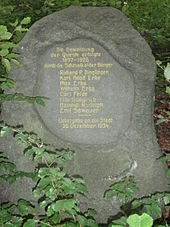
The bare mountain made of red sandstone until the beginning of the 20th century was reforested as a mixed forest by Schmalkalden citizens , primarily with beech , birch and partly with spruce . A memorial stone from 1934 bears the inscription: "The forestation of the Quest was carried out from 1897-1926 by the Schmalkalder citizens (8 names). Handed over to the city in December 1934". A large part of the forest was destroyed by a bomb carpet intended for the city during the American bombing raid on July 20, 1944. The resulting wood was used to support the air raid shelter in Schmalkalden. Even today (2015) there are numerous overgrown bomb craters and also scarred beeches in the forest. The quest has relatively young trees.
On the south-western slope of the mountain is the complex of the Wilhelmsburg renaissance castle, built around 1590 .
The "Berggasthaus Queste", built in 1936, is located on the Queste in a quiet, wooded location. An avenue partly lined with beech leads there.
literature
- Between Ruhla, Bad Liebenstein and Schmalkalden (= values of our homeland . Volume 48). 1st edition. Akademie Verlag, Berlin 1989, p. 167.
Individual evidence
- ↑ Map services of the Federal Agency for Nature Conservation ( information )
- ^ Wieland Jung: The air raids on Schmalkalden in 1944 and 1945 . Schmalkalder history sheets, issue 2/1995. Pp. 143, 148


