Río Papaloapan
| Río Papaloapan | ||
|
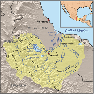
Map of the Río Papaloapan and its catchment area |
||
| Data | ||
| location | Mexico | |
| River system | Río Papaloapan | |
| source | Confluence of the Río Santo Domingo and Rio Valle Nacional 18 ° 1 ′ 52 ″ N , 96 ° 11 ′ 0 ″ W |
|
| Source height | 90 m | |
| muzzle |
Gulf of Mexico Coordinates: 18 ° 47 ′ 20 " N , 95 ° 45 ′ 1" W 18 ° 47 ′ 20 " N , 95 ° 45 ′ 1" W |
|
| Mouth height | 0 m | |
| Height difference | 90 m | |
| Bottom slope | 0.25 ‰ | |
| length | 354 km | |
| Catchment area | 47,756 km² | |
| Drain |
MQ |
1501 m³ / s |
| Left tributaries | Río Tonto | |
| Right tributaries | Río Tesechoacán, Río San Juan | |
| Medium-sized cities | San Juan Buatista Tuxtepec , Cosamaloapan , Tlacotalpan | |
|
Río Papaloapan |
||
The Río Papaloapan is the third largest river in Mexico in terms of the amount of water it carries . Officially, the river is only 354 km long, but together with its headwaters, it extends over 900 km to its confluence with the Gulf of Mexico .
geography
The main source of the Río Papaloapan, the Río Santo Domingo , has its source in the mountains of Oaxaca ; it flows first in a north-westerly direction, then later to the north-east. Only south of San Juan Buatista Tuxtepec - only about 90 m above sea level. d. M. - it unites with the Río Valle Nacional - from then on the river bears the name Río Papaloapan, which in Nahuatl , the language of the Aztecs , means something like 'butterfly river' ( papalotl 'butterfly', apan 'river'). From there it flows northeastwards and flows in the state of Veracruz first into the Laguna Alvarado and from there into the Gulf of Mexico .
economy
The banks of the Río Papaloapan and its tributaries, later also the hinterland, were cleared for centuries. The landscape is now characterized by sugar cane and corn fields as well as cattle pastures. Reservoirs were built on the Río Tonto and the Río Santo Domingo to generate energy and regulate the water level of the river, which repeatedly floods large areas . The construction of fish farms is planned.
Attractions
Because of the frequent flooding, there were no pre-Columbian settlements along the river. The Spaniards founded the port city of Tlacotalpan , which can be reached by sailing ships and which - after a devastating fire in 1788 - was rebuilt in stone using a mixture of colonial and Caribbean style elements. The city was recognized as a World Heritage Site by UNESCO in 1998 .
environmental pollution
Through fertilizers , pesticides and human waste water ( aguas negras ), considerable amounts of poison enter the river in the upper reaches of the Río Santo Domingo; In the lower reaches industrial sewage and considerable amounts of plastic waste are added.
See also
Others
The Mexican poet Joaquín Arcadio Pagaza wrote a poem in honor of the Río Papaloapan .
literature
- Noe Miranda Hernandez: La Esmeralda del Papaloapan . Palibrio, 2013, ISBN 978-1-4633-5382-7 , pp. 176 ff . (454 p., Limited preview in Google Book search).

