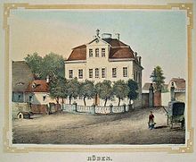
Turnips (place)
Rüben was a village with a manor south of Leipzig in the Pleißenaue . In 1955 it had to give way to lignite mining and was dredged over by the Espenhain open-cast mine . The area has now been recultivated and is now on the south-eastern edge of the Stöhna retention basin . It has been part of Rötha since 1960 .
Location and local characteristics
Rüben was about 14 km south of the center of Leipzig on the east side of the Pleißenaue, which was characterized by numerous river branches and meanders between meadows and small forests due to the low gradient of the river and thus had a park-like character. The fields were east of the village. Rüben belonged to the Borna district .
The neighboring towns of Rüben were clockwise, starting from the north, Zehmen , Magdeborn , Rötha , Böhlen , Stöhna and Großdeuben with Probstdeuben.
Rüben was a cul-de-sac village , at one end of which there was a manor and a church near Plzeen. Then it stretched a bit along the Pleiße to end east on the old Poststrasse. Although predominantly rural, there were some residents who were employed in the lignite industry. Turnips also owned a mill.
traffic
On the eastern edge of the Pleißenaue, the trade route Via Imperii ran in the Middle Ages and touched turnips at his inn on this road. Later the Poststraße Leipzig – Altenburg ran on the same route. With the relocation to the flood-safe route via Magdeborn (later F 95 ), Rüben lost its connection to the trunk road network. The Leipzig – Hof railway line ran west of the Pleiße since 1842. The train stations accessible for beets on this route were Großdeuben and Böhlen. Closer was the Rötha station, 1.5 km away, which had existed since 1913 on the Böhlen – Espenhain railway line .
history
Rüben was first mentioned in 1348 as a mansion in connection with the name Rewin. The name of the nearby village was derived from this name and remained similar: 1445 - Rywen, 1500 - Ryben, 1503 - Ruben - later turnips. In 1444 there is talk of a knight's seat and then of a manor. Over the centuries, its owners were Paul von Gronow, Georg von Haugwitz , Jost Brand and Successor (124 years), Otto Heinrich von Friesen , the von Osterhausen family, the von Dieskau family, Mr. von Boeltzig, Peter Richter and two other generations, Johannes Christian Degner and his heirs Brandstetter. In 1945 the property was expropriated in the course of the land reform and new farmer positions were set up with the associated land. From the ranks of the landowners, Peter Richter, a merchant and merchant in Leipzig, should be noted, who had the church in Rüben built from scratch in 1780/81 using significant private funds. Rüben formed a parish with the neighboring municipality of Zehmen , with the Rübener Kirche being a branch church . Common church school teachers from Zehmen and Rüben have been named since the beginning of the 17th century.
The development of the population of beets was as follows:
| year | 1834 | 1871 | 1890 | 1910 | 1925 | 1939 | 1946 | 1950 | 1957 |
|---|---|---|---|---|---|---|---|---|---|
| Residents | 167 | 170 | 183 | 206 | 243 | 230 | 269 | 302 | 289 |
Until 1856, beet was in the Electoral Saxon or Royal Saxon District Office in Leipzig . From 1856 the place belonged to the Rötha court office and from 1875 to the Leipzig district administration . In 1952 Rüben came to the Borna district in the Leipzig district .
From 1955 the inhabitants of turnips were relocated, the place was devastated and the area was dredged over by the Espenhain open-cast lignite mine. The Pleiße was relocated and straightened. After the site has been recultivated, the former town center of Rüben is located on the southeastern edge of the Stöhna retention basin. The area of the district of the former village Rüben was added to Rötha on January 1, 1960.
Sons and daughters (selection)
- Hans von Bodenhausen-Degener (1839–1912), manor owner, politician, member of the Prussian manor house
literature
- Beets . In: August Schumann : Complete State, Post and Newspaper Lexicon of Saxony. 9th volume. Schumann, Zwickau 1822, p. 536 f.
- Cornelius Gurlitt : Turnips. In: Descriptive representation of the older architectural and art monuments of the Kingdom of Saxony. 16. Issue: Amtshauptmannschaft Leipzig (Leipzig Land) . CC Meinhold, Dresden 1894, p. 109.
- GA Poenicke (Ed.): Album of the manors and castles in the Kingdom of Saxony based on nature, newly recorded by F. Heise, Architect. I. Section: Leipziger Kreis. Leipzig [around 1860].
- Saxony's church gallery. Volume: Inspections Leipzig and Grimma. Hermann Schmidt, Dresden 1837–1845
- Henriette Krahnstöver: Between Rüben and Güldengossa, from the memoirs of the castle gardener Reinhold Hofmann in the Leipzig area , Verlag Pro Leipzig, 2012, ISBN 978-3-936508-78-9 , p. 23 Mention of Constantin and Hans-Eberhard von Bodenhausen and explanations on the manor Rüben, pp. 13–25. Also from the memoirs of Reinhold Hofmann, Part I - The time in Rüben 1875–1903, Family and Childhood , pp. 26–53.
Web links
- Turnips in the Digital Historical Directory of Saxony
- Espenhain opencast mine
Individual evidence
- ↑ a b Rüben in the Digital Historical Directory of Saxony
- ↑ Entry on Schlossarchiv.de
- ↑ GA Poenicke (Ed.): Album of the manors and castles in the Kingdom of Saxony, Leipzig district. P. 123
- ↑ Saxony's Church Gallery. Volume: Inspections Leipzig and Grimma. Hermann Schmidt, Dresden 1837–1845, p. 85.
- ^ Karlheinz Blaschke , Uwe Ulrich Jäschke : Kursächsischer Ämteratlas. Leipzig 2009, ISBN 978-3-937386-14-0 ; P. 60 f.
- ↑ The Amtshauptmannschaft Leipzig in the municipal register 1900
Coordinates: 51 ° 13 ′ 0 ″ N , 12 ° 24 ′ 26 ″ E


