Reichpietschufer
| Reichpietschufer | |
|---|---|
| Street in Berlin | |
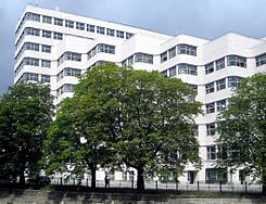
| Shell House on Reichpietschufer seen across the Landwehr Canal | |
| Basic data | |
| place | Berlin |
| District |
Kreuzberg , Tiergarten |
| Created | in the 19th century |
| Hist. Names |
Grabenstrasse , Königin-Augusta-Strasse , Tirpitzufer |
| Connecting roads |
Hallesches Ufer (east) , Corneliusstrasse (west) |
| Cross streets |
(Selection) Eichhornstrasse , Potsdamer Strasse , Stauffenbergstrasse , Hiroshimastrasse |
| Buildings |
GIZ House , Berlin Science Center for Social Research , Shell House , southwards the bridges over the Landwehr Canal |
| use | |
| User groups | Road traffic |
| Technical specifications | |
| Street length | 1670 meters |
The Reichpietschufer is a riverside street in the Berlin districts of Kreuzberg and Tiergarten , which runs north of the Landwehr Canal. The street Schöneberger Ufer forms the opposite south bank of the Landwehr Canal .
location
The Reichpietschufer extends from Von-der-Heydt-Strasse (Tiergarten district) in the west to Halleschen Ufer and Köthener Strasse (Kreuzberg district) in the east.
Between the Hallescher Ufer and the entrance to the Tiergarten Spreebogen tunnel , the Reichpietschufer forms the northern lane of the inner city ring .
At the western end of the street is the Caladrelli complex with the Villa von der Heydt and an oriental plane tree , which has been designated a natural monument 1-16 / B by the city of Berlin.
history
Since July 31, 1947, the street has been named after Max Reichpietsch (1894–1917), one of the organizers of the anti-war movement among the sailors of the German deep-sea fleet in the summer of 1917. When it was built in 1831, it was called Grabenstrasse . It was renamed on January 6, 1867 after the Prussian Queen Augusta in Königin-Augusta-Strasse and on December 7, 1933 in Tirpitzufer after Grand Admiral Alfred von Tirpitz . The renaming was related to the Bendler Block (formerly Queen Augusta-Straße 38-42 , today Reichpietschufer 72-76), where in 1914 the Admiralty of the Imperial Navy had its headquarters. The building complex housed the naval command of the Reichsmarine from 1920 and, during the time of National Socialism, parts of the high command of the navy of the Wehrmacht . After the Second World War, the renaming now honored the revolting sailors Reichpietsch and Albin Köbis (Köbisstraße).
The development of the Reichpietschufer conveys the image of closed urban density. In connection with the International Building Exhibition Berlin , the complex of the Berlin Science Center for Social Research (house number 50) was built, in which the listed front building of the Reich Insurance Office was included. The Bendlerblock, the Shell house (house number 60) and the GIZ house (house number 20) are also listed buildings.
Moving away from the city, almost at the end of the Reichpietschufers on Hiroshimastraße , the representation of the state of Bremen at the federal government , designed by the office of Léon Wohlhage Wernik , was established in 1999 . The complex forms the transition between the urban cityscape in the south and the embassy district in the north with its villa character.
literature
- Markus Sebastian Braun (Ed.): Berlin. The architecture guide . Econ Ullstein List, Munich 2001, ISBN 3-88679-355-9 .
Web links
-
Reichpietschufer. In: Street name lexicon of the Luisenstädtischer Bildungsverein (near Kaupert )
- Grabenstrasse . In: Luise.
- Queen Augusta Street . In: Luise.
- Tirpitzufer . In: Luise.
- Reichpietschufer . In: District lexicon of the Luisenstädtischer Bildungsverein
Individual evidence
- ↑ New Invalidenstrasse - there are plans and complaints . In: Berliner Zeitung , May 12, 2009
- ^ Berlin Central Station - The Project . At: Senate Department for Urban Development
Coordinates: 52 ° 30 ′ 22.3 " N , 13 ° 21 ′ 54" E

