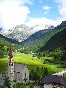
Pure in Taufers
Rein in Taufers ( Italian Riva di Tures ) is a fraction of the market town of Sand in Taufers in South Tyrol ( Italy ).
The place with about 340 inhabitants is located at 1600 m altitude in the Reintal , a side valley of the Tauferer Tal .
history
Rein is first mentioned in a document in 1225 as a Riune . The name is derived from the Latin rius, rivus and means something like small brooks .
The first traces of an inspection of the area by humans go back to the Middle Stone Age (approx. 8,000 to 5,500 BC). The only hunter's resting place in the Tauferer Ahrntal area that has so far been reliably proven was discovered in 1984 at the Klammljoch ( 2294 m ).
In the summer of 1992, pieces of clothing from the Iron Age were found near the Rieserfernerhütte .
A deed of donation indicates that a church consecrated to Saint Wolfgang was built in Rein around 1419 . According to legend, St. Wolfgang also came to the then pagan Rein during his missionary work in Norikum . Today's church was rebuilt from 1908 to 1911 in neo-Gothic styles according to plans by the diocesan architect Peter von Stadl (also: Vonstadl). The parish church of Rein is one of the few church buildings in South Tyrol that were built in the neo-Gothic style.
For the history of Rein see Tyrol , South Tyrol and History of South Tyrol .
landscape
Rein is surrounded by the Rieserferner-Ahrn Nature Park in a scenic, high-alpine location in the Rein valley. The place is the starting point for a large number of mountain tours in the Durreck and Rieserferner groups . The local mountain is the Hochgall , at 3436 m the highest mountain in the Rieserferner group of the Hohe Tauern , which can be reached via the Kasseler Hütte (also Hochgallhütte) in a demanding tour (only for experienced alpinists).
On the Tristennöckl above the Kasseler Hütte you can find the highest stone pine population in the Eastern Alps at just under 2300 m . The Reinbach forms three impressive waterfalls in the Reinbach Gorge, which can be reached via the Franziskusweg, which was inaugurated in 1985.
economy
The most important industry is tourism with a year-round season. Even before the First World War, Rein was a popular tourist destination because of its natural beauty and mighty mountains. There are several hotels, restaurants and private accommodation facilities in the village, as well as two small ski lifts and a cross-country skiing center. The 15 km of cross-country ski trails - with a biathlon shooting range - are part of Dolomiti Nordic Ski, the largest cross-country ski carousel in Europe.
The farmers have completely given up growing potatoes and cereals and are now only raising cattle and forestry .
Since 2002 there is a wind power plant in Rein with a nominal output of 300 kW, which also contributes to the power supply of the community. It is the first such facility in South Tyrol. The hydropower plant (high pressure diversion power plant) on the Reinbach, completed in 2008 between Rein and Sand in Taufers, delivers an average of 63 million kWh of electricity annually with a catchment area of 91 km² and a nominal head of 432 m.
literature
- Josef Innerhofer : Taufers, Ahrn, Prettau - The story of a valley . Publishing house Athesia, Bozen 1980.
- Reimo Lunz: Archaeological forays through South Tyrol . Volume 1. Athesia Publishing House, Bozen 2005.
- Municipalities of the Tauferer Ahrntal (ed.): Kulturmeile Tauferer Ahrntal . Tappeiner Verlag, Lana 2004.
- Zeno Braitenberg (editor): Tauferer Ahrntal - history and future . Tappeiner AG, Lana 2007.
- Markus Mahlknecht: Mesolithic finds from the Original Valley (Rein) . In: Der Schlern 81, 2007, pp. 17-19.
- Serafin Bacher: At the foot of the Hochgall - Dorfbuch . Without publisher information, effect! Book, Neumarkt a. d. Etsch 2010.
Web links
Individual evidence
- ↑ a b Josef Weingartner : The art monuments of South Tyrol. Volume 1: Eisacktal, Pustertal, Ladinien. 8th edition, edit. by Magdalena Hörmann-Weingartner. Bozen-Innsbruck-Vienna: Athesia-Tyrolia 1998. ISBN 88-7014-360-0 , pp. 579-580.
Coordinates: 46 ° 57 ' N , 12 ° 4' E
