
Reversing Falls

The Reversing Falls are rapids at the mouth of the Saint John River in the Bay of Fundy . They are located near Saint John in the Canadian province of New Brunswick . Due to the exceptionally large tidal range in this bay , the direction of flow of the Saint John River in the mouth area reverses depending on the tides . A rocky sill in the river bed ( Upper Falls ) and an adjoining narrow gorge ( Lower Falls ) reduce the cross-section of the flow and increase the flow in such a way that, at both ebb and flow, there are gradients and consequently rapids, each in the opposite direction. Safe shipping in this part of the river is only possible in the times of weak current between ebb and flow.
Location and surroundings

The Saint John River flows from the north about 4 km after the Reversing Falls in the middle part of Fundy Bay . Above the falls, it flows through a fjord that merges into a larger inland basin, Grand Bay . It is followed by a narrower section, about four kilometers long, before another somewhat wider basin that joins the falls is created at Indiantown , a district of Saint John .
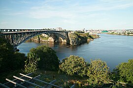
At the Upper Falls, about two kilometers below Indiantown, the river narrows quite immediately to a width of 215 meters. There is also a shoal here, the Reversing Falls Sill . Now the river widens again a little before, after about 600 meters, it passes the narrowest point of 106 meters, the Lower Falls . Two bridges, which are both named after the phenomenon of Reversing Falls , a railway bridge and a road bridge, run over this. Below this narrow point, the river bends sharply to the left for about two kilometers before, after an approximately right-angled right-angled bend, it reaches the port basin of Saint John, which opens to the Bay of Fundy.
Hydrological properties


South of Indiantown, at the beginning of Reversing Falls, the flow gradient of the Saint John River is relatively strong during low tide, it is four meters for the following three kilometers. The average amount of fresh water that the Saint John River transports into the sea is around 1100 m³ / s, but can briefly rise to over 10,000 m³ / s during the snowmelt in spring. The threshold at the beginning of the Reversing Falls, the so-called Reversing Falls Sill , and the narrow gorge that follows after a few hundred meters impede such a flow at normal water level, which is also only slightly above mean sea level . Even during low tide, the water at Reversing Falls Sill must be at least 5 meters deep so that the fresh water can flow away.
The Bay of Fundy is known for its exceptionally large tidal range. The tidal range in the mouth of the Saint John River is comparatively modest with an average of 6.7 meters for the bay, in extreme cases it can be up to 9.1 meters. The ebb and flow alternate twice a day, the spring-nipp cycle lasts 14 days. At low tide, the water level in the harbor bay is usually four meters lower than the water level at Reversing Falls Sill . At this stage a mixture of fresh water and sea water from the previous high tide flows downstream through the Reversing Falls. The tidal range above the Reversing Falls is only about half a meter due to its dampening effect at Indiantown. This means that the water level of the harbor basin during normal flow of the Saint John River is 1.7 to 4.2 meters above that of Indiantown at high tide, depending on the height of the tide. During this phase, the direction of flow of the Saint John River below Indiantown is reversed and the flow gradient in connection with the narrowed cross section in the area of the Reversing Falls is sufficient that rapids also form inland. During the snowmelt in spring, the water level above the Reversing Falls can be permanently above that in the harbor basin - then there is no reversal of the direction of flow. Long-term recordings of the water levels suggest that about two thirds of the time the Saint John River flows towards the sea in the area of the Reversing Falls.

Below the narrow gorge: about two hours after the high tide, the direction of current is still inland.
The tide was tide between ebb and flow (slack tide) about 38 minutes later.
Another 15 minutes later, the Saint John River is already flowing towards the sea again.


tourism
The Reversing Falls have been a tourist attraction in the city of Saint John since the 1840s. In the lower section of Reversing Falls near the narrowest part of the river, the first bridge was built in 1853 - after a few unsuccessful attempts - to connect the city with its western environs. Until well into the 20th century, tourists were only offered a shelter and a picnic table in addition to a footpath for sightseeing. Since the 1930s, there was a shop on the east side of the bridge where you could buy souvenirs and the chronology of the tides was published. In 1955, a tourist office was opened in the place of the shop, which comes close to today's ideas of such an establishment.

When the Saint John Harbor Bridge was opened in 1968 and there was thus another possibility of crossing the river further downstream, the previously satisfactory number of visitors collapsed dramatically. Until then, the tourist attraction was mostly called “Reversing Fall Rapids” - in contrast to the section of the river, which has always been simply but perhaps somewhat dramatically called “Reversing Falls”. It was now decided to remove the "Rapids" - the hint that it is "only" about rapids - from the name of the tourist attraction in order not to deprive tourists of the illusion that it could be something , the backward flowing Niagara Falls (engl. Niagara Falls ) would be equivalent. It is possible that this name change also led to the fact that some visitors had too high expectations and felt cheated. In order to avoid this, the term "Reversing Rapids" is now also in use, which completes the confusion. What may also contribute to the disappointment of some tourists is the fact that one would have to wait a little over six hours to witness a complete reversal of the direction of flow.
From 1995 to 2014, jet boat tours were offered in the Reversing Falls area. Kayakers try their hand at the rapids, but some get into trouble and need to be rescued. Since the jetboats were often in the water at the same time, they occasionally took on rescue missions.
History and legends
According to an Indian legend, the great beaver once built a mighty dam in the mouth of the Saint John River. Much to the annoyance of the other animals, the dam dammed a huge lake over the whole country from Jemseg to Keswick . Glooscap - a figure of Indian mythology, a so-called cultural hero - was called to help. With his heavy club he destroyed the dam and the floods washed part of it out into the Bay of Fundy. It is said that Partridge Island , the barrier island south of Saint John, is the remnants of this dam - the Indians call this island Quak-m'kagan'ik, which means something like "a cut piece". They call the Reversing Falls Quabeet-a-wee-soga, something like "the beaver's overturned dam". It is also said that Split Rock, the small rock island immediately south of the bridges, is Glooscape's club, which he threw away after the work was done.
On June 24, 1604, the first Europeans reached the mouth of the Saint John River. The leader of the expedition was Pierre Dugua de Mons , a French explorer and trader who was accompanied by Samuel de Champlain , a French explorer and cartographer. The Reversing Falls already attracted the interest of the first researchers and they described this section of the river more or less precisely in their diaries and reports. Pierre Biard , a Jesuit missionary who came to this area in 1611, described the river section at the narrowest point in the following words:
"The entrance to this river is very narrow and very dangerous, for the ship has to pass between two rocks, where the current of the tide is tossed from the one side to the other, flashing between them as swift as an arrow."
"The entrance to the river is very narrow and very dangerous, as a ship has to pass between the two rocks, where the current of the tides is driven from one side to the other and rushes between the sides like an arrow."
Individual evidence
- ^ Manfred Schmidt: Geographical curiosities. Page 150f, Grin Verlag, Munich 2008, ISBN 3-638-95530-3
- ^ A b Paul R. Pinet: Invitation to Oceanography. 6th edition, Jones & Barlett Learning, Burlington 2013, ISBN 978-1-4496-0191-1 , pp. 263-266
- ^ Carl Herzog (Ed.): Reed's Nautical Almanac East Coast 2009. Thomas Reed Publications, 2009, ISBN 1-884666-95-7 , p. 337
- Jump up to the Grand Bay also a fjord through which the Kennebecasis River flows into the Saint John River.
- ↑ 215 meters is the sum of the main culvert and the secondary culvert between Crow Island, located near the left bank, and the bank.
- ↑ a b c d Con Desplanque, David J. Mossman: Tides and their seminal impact on the geology, geography, history, and socio-economics of the Bay of Fundy, eastern Canada. In: Atlantic Geology. Volume 40, 2004, pp. 66-69 ( online )
- ↑ In the Reversing Falls there are no individual obstacles that are often present in rapids and protrude above the water surface, with the exception of the edges, where they are only visible when flowing forward (ebb).
- ↑ a b c Vincent. Leys: 3D Flow and Sediment Transport Modeling at the Reversing Falls - Saint John Harbor, New Brunswick. In: Oceans 2007. pp. 1–16 ( summary )
- ↑ On the opposite bank of the Spring Rock, an obstacle visible at low tide in the lower narrow point.
- ^ A b c Harold E. Wright, Joseph Goguen: Bridging Saint John Harbor. Arcadia Publishing, Charlston 2013, ISBN 978-1-4671-2010-4 , pp. 79-87 ( Google Books )
- ^ CTV Atlantic: Tourists confused by iconic Reversing Falls. July 9, 2012
- ↑ CTV Atlantic: Paddlers rescued from Reversing Falls after kayak overturns. May 28, 2013
- ^ A b W. O. Raymond: The River St. John, its physical features legends and history from 1604 to 1784. The Strathmore Press, St. John 1910, p. 37f ( online )
Web links
Coordinates: 45 ° 15 ′ 37 " N , 66 ° 5 ′ 24" W.