
Riesloch Falls

The Riesloch Falls are waterfalls in the Bavarian Forest .
About two kilometers north-east of Bodenmais , the Riesloch, the right Schwellbach, which was previously reinforced by the Arberbach, the Kleinhüttenbach and the left Wildauerbach merge to form the Riesbach. The creek gorge, created by back-cutting erosion in the gneiss subsoil, extends at an altitude of 780 to 920 meters over a sloping section 1.6 kilometers in length. In the upper part, water has been diverted to generate electricity since 1908, as a result of which the falls have lost their abundance of water.
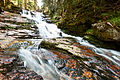
The Riesloch Falls are located where the streams overcome the steep step at the eastern entrance to the gorge and offer an impressive natural spectacle, especially when the water level is high after the snow has melted or when there is heavy rain. In five mostly sliding main steps, they have a total height of 55 meters, the main case is 15 meters high.
The overflowing rocks are partly completely overgrown with moss, and there are occasional whirlpool holes in the rocks . The jungle-like forest stock of old mixed mountain forests and spruce forests with floristic and faunistic ice age relics in the gorge is also significant . The dominant shrub in the upper part of the gorge is the large-leaved willow ( Salix appendiculata ). The black honeysuckle ( Lonicera nigra ) and the alpine motherwort ( Ligusticum mutellina ) also occur here, but an occurrence of the blue honeysuckle ( Lonicera caerulea ) reported by Otto Sendtner in 1860 could no longer be confirmed.
natural reserve
On March 28, 1939, published in the Bavarian Government Gazette on April 14, 1939, an area of 32.9 hectares was designated as a Riesloch nature reserve. In addition, the state forest administration established a 48.5 hectare natural forest reserve of the same name .
Geotope
The Rieslochfall near Bodenmais has been designated as an important geotope by the Bavarian State Office for the Environment (geotope number: 276R006).
A classic hiking route leads through the Riesloch from Bodenmais to the Großer Arber . There are no trails in the nature reserve .
gallery

Riesloch - main section
Riesloch - main section, top view

Riesloch, pond between the sections

View of the Riesloch Falls in winter


literature
- Walter Meier: The nature reserves in the Arber area, a brief description , in: The nature reserves on the Arber . Bavarian State Office for Environmental Protection, Issue 144, 1997, ISSN 0723-0028
- Hansjörg Gaggermeier : Flora and vegetation in the nature reserves "Großer Arbersee and Arberseewand" and "Riesloch" , in: The nature reserves on the Arber . Bavarian State Office for Environmental Protection, Issue 144, 1997, ISSN 0723-0028
Individual evidence
- ↑ Bavarian State Office for the Environment, Geotop Rieslochfall NE von Bodenmais (accessed on October 18, 2017).
Web links

Bach learner Moos | Birkenbruchwald Oed | Großer Arbersee and Arberseewand | Large stake and stake bolt St. Antonius stake | Courtyard stake | Kiesau | Mitternacher Ohe | Moosbach stake | Post at the ruins of Weißenstein | Riesloch | Red felt | Stockau meadows | Stockwiesen near Schollenried | Todtenau and surrounding meadows
Coordinates: 49 ° 5 ′ 15 ″ N , 13 ° 6 ′ 51 ″ E