River Brent
|
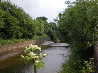
River Brent Dollis Brook in the upper reaches |
||
|
The Brent at Greenford |
||
| Data | ||
| location | London | |
| River system | Thames | |
| source | in the London Borough of Barnet 51 ° 38 ′ 12 ″ N , 0 ° 14 ′ 34 ″ W |
|
| muzzle | in Brentford in the Thames Coordinates: 51 ° 28 ′ 59 " N , 0 ° 17 ′ 59" W 51 ° 28 ′ 59 " N , 0 ° 17 ′ 59" W
|
|
| Left tributaries | Folly Brook , Clitterhouse Brook , Silk Stream , Wealdstone Brook | |
| Right tributaries | Mutton Brook | |
| Reservoirs flowed through | Brent Reservoir | |
The Brent is a tributary of the Thames in south east England , which gave the London Borough of Brent its name. It has a length of 29 km and extends partly underground within Greater London . The name of the river goes back to a Celtic deity. The Brent and the valley surrounding it are the result of glacier movements during the Saale Ice Age .
Originally the river was around 120 meters above sea level . The source of the Brent is located in Moat Mount Open Space in the London Borough of Barnet . It arises there as Dollis Brook and initially flows east to east of New Barnet and from there in a southerly direction. By the time the river reaches the Brent Cross Shopping Center, it changes its name to the River Brent. Under this name it flows shortly thereafter into the reservoir of the Brent Reservoir and after leaving it on to Brentford .
Before it was straightened in the 20th century, the Brent was a bigger river than it is today. However, when it was decided to build houses and streets in the immediate vicinity of the river, straightening measures were taken, which began around 1937. In addition, the pollution of the river has increased noticeably since then.
See also
Web links
- Information on Brent (in English)
