
SRTM data
SRTM data (from Shuttle Radar Topography Mission) are remote sensing data of the earth's surface recorded from space during the STS-99 Shuttle Radar Topography Mission (SRTM) in February 2000. They are used to create a uniform, high-resolution digital terrain model of the earth's surface.
With SRTM, even inaccessible regions of the world were recorded and measured within 11 days. Land areas between the 60th north and 58th south latitude were covered ; due to the inclination of the orbit , the poles are not included in this database. Since August 7, 2015, the complete data is freely available with a resolution of 1 arcsecond (approx. 30 m).
Collection of data: SIR-C, X-SAR


The SRTM radar system was part of the mission equipment of the Space Shuttle Endeavor on the transport mission 99. It consisted of two components:
- the SIR-C, developed by NASA , produced data from almost 100% of the measured earth's surface with a horizontal resolution of about 30 meters and an altitude accuracy of about 6 meters. The data produced were evaluated by NASA's Jet Propulsion Laboratory and are partially available free of charge on the Internet as a public domain from the US Geological Survey (US geological service) .
- the X-SAR from the German Aerospace Center , whose data are more accurate, but only cover 40% of the earth's surface. The elevation data recorded using Synthetic Aperture Radar reflect the surface shape of the earth, including vegetation and buildings , which leads to corresponding deviations from the ground.
This type of remote sensing has great advantages in contrast to the early days of geodesy : Previously, the height and position of a place on the earth's surface was determined using triangulation based on reference points. This is associated with a lot of effort, as the measuring points must be within sight. Distant locations therefore had to be recorded using intermediate steps, and inaccessible areas could not be measured at all or only insufficiently.
United States Geological Survey data
Data format and resolution: SRTM-1, SRTM-3
Initially, the USGS made two different data sets available for free use:
- For the entire measured area, the data is available with a resolution of one arc second in length and width (SRTM-1). This data is offered in pieces of 1 degree × 1 degree with a size of 3601 × 3601 pixels.
- In addition, the data is offered with a reduced resolution of 3 arc seconds (SRTM-3). The size of the 1- × -1 degree pieces is here 1201 × 1201 pixels.
- The USGS user interface also allows a freely definable rectangular selection of any areas for which the data records are individually compiled and transmitted to the user.
- Note: At the equator , one arc second is approximately 30 meters or three arc seconds is approximately 90 meters. The distance between the longitudes decreases towards the poles (see expansion ).
The data records are offered as matrices of 16-bit integer numbers (big-endian byte order ) on the USGS's FTP servers. They are also available in different file formats in various places. The height is shown in meters. Pixels for which no height information is available are given the value −32768.
The height information of the surface measurement relate to the worldwide uniform reference system WGS84 EGM96 Geoid , the horizontal georeferencing takes place with WGS84 as geodetic datum . In contrast, existing, nationally recorded elevation models had different reference systems, which made their further processing difficult.
In the course of the climate summit in 2014 , the US government announced that it wanted to make SRTM-1 data freely available for areas outside the US within one year. With the release of the data for the Middle East on August 7, 2015, the announcement was fully implemented. The old data records can still be called up.
Filenames
The USGS file names (example: "N53E009" for 53 ° North geographical latitude and 9 ° East ( East ) geographical longitude) relate to the longitude and latitude of the lower left corner of the data field shown, ie the image pixel (1,1).
Data versions
The initially published data (version 1) show not only missing pixels without height information, but also other measurement errors and water surfaces do not have a constant height value. In 2005, the data were therefore reissued with improved quality (Version 2). In 2009 version 2 was revised again and released as version 2.1.
Copyright and usage rights
The data published by the USGS can be downloaded free of charge as a public domain and may be used without restriction: USGS-authored or produced data and information are in the public domain . The unpublished data with an arcsecond resolution of territories outside the US is under the control of the US Department of Defense.
Data from the German Aerospace Center: SRTM / X-SAR
The data recorded by the X-SAR can be downloaded free of charge from DLR in DTED format . The openDEM project provides a free elevation model that has been further refined by editing with freely accessible data such as OpenStreetMap or viewfinderpanoramas.
Data quality
The resolution of the X-band height data from DLR is 25 m horizontally and 1 m vertically. The accuracy is horizontal 20 m absolute, 15 m relative and vertical 16 m absolute, 6 m relative.
Copyright and usage rights
The DLR's X-band elevation data itself may not be passed on. However, works derived from the data (maps, etc.) are not subject to any restrictions on use other than the obligation to name the source.
Weak points
For technical reasons and to reduce the amount of data, the database is incorrect:
- The elevation data reflect the surface structure of the earth. This does not have to correspond to the height of the ground, see vegetation, development, etc.
- In some places where the measurements showed excessive errors or the received radiation was too low, the data show "holes" (missing pixels). There are several possible reasons for this: In areas with steep slopes, the transmitted energy was reflected by mirror reflection in a direction other than back to the radar. On very flat surfaces of water, ice or sand, the transmitted pulses were so strongly dispersed by diffuse scattering that the echo signals at the radar receiver were too small to be recognized. Very dense and permanent cloud cover prevented “vision” due to ice particles (for example in thunderclouds), which means that the transmission loss in such areas is too great for electromagnetic waves so that no echo signals could be received.
- The horizontal grid of around 90 meters × 90 meters does not represent a complete image of the orography . Points that lie between the raster points must be interpolated during further processing, ideally using higher-resolution information.
- Due to the altitude reference model used, some programs show a wrong coastline, since the zero meter mark of the data does not have to match the local sea level in reality. The keyword geoid gives further explanations. Furthermore, some areas near the coast are protected by a dike below sea level. The quality of the location of the coastlines was improved in the new publication of the data in 2005. The coastline maps used have also been published.
Correction of the missing pixels
In order to fill the places for which no height information could be determined (missing pixels), various methods are common:
- Interpolation from the existing values. This leads to inaccuracies, especially with larger gaps in mountain regions.
- Correction using data from other sources. The quality of the results with this method depends essentially on the quality of this data. The deviation of the height values in the SRTM data due to vegetation and development from conventionally determined height data must also be taken into account.
software
The USGS provides the public domain software dlgv32Pro , which is a limited freeware version of the Global Mapper , for viewing . There is also various commercial and non-commercial software (freeware, shareware) that can process SRTM data. As free software , GRASS GIS can import SRTM data with the r.in.srtm module , and the free GPS track analysis program also uses SRTM data. The data is or was also available in GeoTIFF format, which can be read by all common GIS and image processing programs.
Examples

Incorrect coastline: The picture shows an area of the Elbe estuary. The red line marks the real course of the bank, the Elbe runs south of this line.
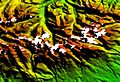
Missing pixels: The mountain peaks of the High Tatras are missing in the picture due to total reflection of the radar waves. This effect can occur through ice or snow surfaces as well as on steep mountain slopes. Likewise, water surfaces can lead to faulty pixels.

Elevation map of the Sierra Nevada by Maps-For-Free calculated from SRTM elevation data

Hillshade and contour lines from SRTM data in an OpenStreetMap map (OpenTopoMap)


See also
Web links
Data sources:
-
SRTM data, original data sets:
- dds.cr.usgs.gov , United States Geological Survey USGS (SIR-C data)
- geoservice.dlr.de , German Aerospace Center (X-SAR data)
-
SRTM and Void Data - post-processed and with correction of the missing pixels by interpolation:
- srtm.csi.cgiar.org , CGIAR - Consortium for Spatial Information CGIAR-CSI (Version 4 3/2009, further links)
- ambiotek.com , King's College London (CGIAR data as KML for Google Earth )
- esdac.jrc.ec.europa.eu , European Commission - DG JRC (CGIAR data via WMS viewer, Europe only)
Individual evidence
- ↑ Announcement of the publication of the last section with 1 arc second resolution , lpdaac.usgs.gov (English)
- ↑ Coverage of the earth's surface by the SRTM mission , jpl.nasa.gov (English)
- ↑ Instructions for the free selection of USGS data ( Memento from July 1, 2009 in the Internet Archive ), herbert.gandraxa.com (English)
- ↑ US Releases Shuttle Land Elevation Data to Aid Global Climate Resilience , NASA (English)
- ↑ What are these (PDF; 21 kB), dds.cr.usgs.gov - versions of the SRTM datasets (PDF, English)
- ↑ Summary of the guidelines for the publication of the SRTM data , jpl.nasa.gov (English)
- ↑ Elevation models of the SRTM mission are available free of charge ( memento of March 13, 2013 in the Internet Archive ). DLR press release of May 25, 2011
- ↑ openDEM
- ↑ viewfinder panoramas