
Saint Paul River
|
Saint Paul River Nianda, Diani (until leaving the border with Guinea) |
||
 Rivers of Liberia, red: Saint Paul River system |
||
| Data | ||
| location |
|
|
| River system | Saint Paul River | |
| source | at Macenta 8 ° 42 ′ 50 ″ N , 9 ° 10 ′ 59 ″ W. |
|
| Source height | 960 m | |
| muzzle | Monrovia Bay Coordinates: 6 ° 22 ′ 47 " N , 10 ° 48 ′ 0" W 6 ° 22 ′ 47 " N , 10 ° 48 ′ 0" W. |
|
| Mouth height | 0 m | |
| Height difference | 960 m | |
| Bottom slope | 2 ‰ | |
| length | 485 km | |
| Catchment area | 20,281 km² | |
| Discharge at the Haindi gauge (04SP001) A Eo : 18,276 km² Location: 104 km above the mouth |
NNQ (03/18/2019) MNQ 2012–2019 MQ 2012–2019 Mq 2012–2019 MHQ 2012–2019 HHQ (09/14/2016) |
16 m³ / s 65 m³ / s 474 m³ / s 25.9 l / (s km²) 1400 m³ / s 2394 m³ / s |
| Left tributaries | Mein Creek, Wata, Wala Creek, Mehn Creek | |
| Right tributaries | Diani (Nianda), Via , Tuma Creek , Gola Creek, Mwawo Creek | |
| Reservoirs flowed through | Mount Coffee Dam | |
| Big cities | Monrovia | |
| Small towns | Clay-Ashland | |
| Communities | Arthington (Liberia) , Dixville (Liberia) , Saint Paulsville | |
| Residents in the catchment area | 1,026,515 | |
| Navigable | approx. 30 km on the lower reaches | |
| In the late 19th century there was a steamship line | ||
The Saint Paul River is a river in West Africa . It rises in the southeast of the Republic of Guinea . The river is considered the most important river in the Republic of Liberia and crosses the central provinces.
description
The approximately 500 km long river rises as Diani or Nianda in southeast Guinea in the mountainous region northeast of Macenta . After about 50 km the river reaches the border of Liberia, which it forms from now on for about 50 km. After leaving the border, the name changes to Saint Paul and flows in a south-westerly direction through central Liberia. The mouth of the Saint Paul River is at Monrovia Bay , about 5 km north of Freeport Monrovia , from which two railway lines and an arterial road lead into the northern hinterland, for this purpose the St. Paul Bridge and the Tubman Bridge .
The originally funnel-shaped estuary with an opening width of around 1100 m was filled with alluvial sand and the river sediments at the edges. The width of the river is now barely 150 m at the mouth. At the beginning of the 19th century, mangrove forests lined the lower reaches; they were felled after the settlement of Clay-Ashley was founded in order to be able to create agricultural plantations ( coffee , sugar cane and oil palm plantations ).
The Stockton Creek is a specialty , it is an estuary of the Saint Paul River and is connected to the Mesurado River . The connection has the effect that the stretch of coast between the two rivers is perceived as an island called " Bushrod Island ".
In the 1970s, the Hotel Africa was built at the estuary ; it was one of the luxury hotels in West Africa until it was closed and later looted during the civil war .
history
The estuary near Cape Mesurado on the West African coast, the so-called Pepper Coast, which was explored by Portuguese sailors in the 15th century , was reached on January 25, the feast of the conversion of the Apostle Paul , so the explorers named the river Rio São Paulo . However, it was not until the 1920s that the extensive headwaters on the upper reaches could be fully explored geographically. The area on the lower reaches of the lower reaches, which was bought and settled by the American Liberians at the beginning of the 19th century, became the center of the Liberia colony, where the colonist towns and plantations around Clay-Ashland , Bensonville , Dixville (Liberia) and Millsburg emerged . In order to be able to transport the agricultural products more efficiently to Monrovia, at the suggestion of the American missionary David Day of the Muhlenberg Mission, a first “steamship line” was created on the Saint Paul River with the steamboat “Sarah Ann”, it ran up to 30 kilometers deep inland and ended at the rapids at White Plains .
Water flow
The Saint Paul River is located in the tropical rainforest of West Africa and its water flow has been monitored by the Hydrographic Service of the Republic of Liberia.
- on the middle reaches, at the hydrographic station "Walker Bridge", Liberia, catchment area 9 760 km², the maximum is reached in September, it is then 728 m³ / s, the minimum is registered in February and March with 37.3 m³ / s.
- on the lower reaches, at the hydrographic station "Haindi (04SP001)", Liberia, catchment area 18,276 km², the highest measured discharge in September 2016 was 2394 m³ / s and the minimum in March 2019 was 16 m³ / s. The average discharge is 474 m³ / s (see diagram).

Energy generation
The Mount Coffee Dam was the most important power station in Liberia until the Liberian Civil War. The generator plant was built from 1963 to 1966 on the lower reaches of the Saint Paul River and is located about 30 km northeast of the capital Monrovia. The power plant was planned as a run-of-river power plant . At the site near Arthington and Milsburg, near Mount Coffee , a dam about 150 m long and a turbine house were built. The site was on a bend in the river, where a natural branch of the Saint Paul River could be used to regulate the water level. Further technical systems and accommodations for the staff were built 500 meters south of the dam on a hill.
Natural resources
The area of the Saint Paul River has been systematically geologically investigated since 2005, for the first time deposits of minable ores (gold, iron ore, copper, platinum, uranium, bauxite) and diamonds were recorded.
Nature reserve
On the advice of international nature conservation organizations, parts of the mangrove area , an area of around 6000 hectares on the lower reaches of the Saint Paul River and the Mesurado , were designated as a nature reserve.
literature
- JW Lugenbeel: The republic of Liberia: its geography, climate, soil and productions, with a history of its early settlements . GS Stockwell, New York 1868, p. 299 . ( Digitized at Google Books)
Web links
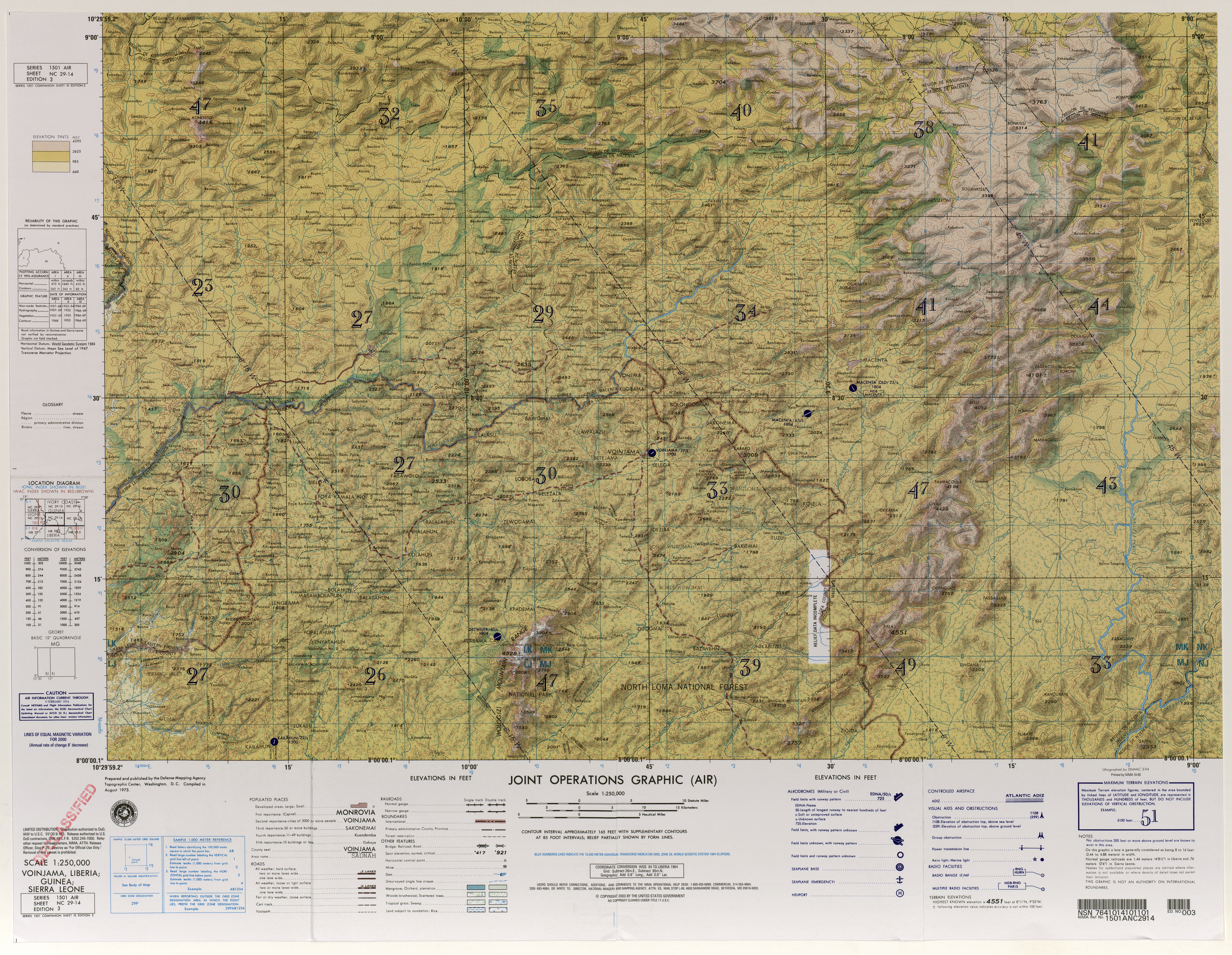
- TK250 NC29-14 (GUÉKÉDOU) , US Army Map Service (Ed.), Washington 1954, (headwaters in Guinea)
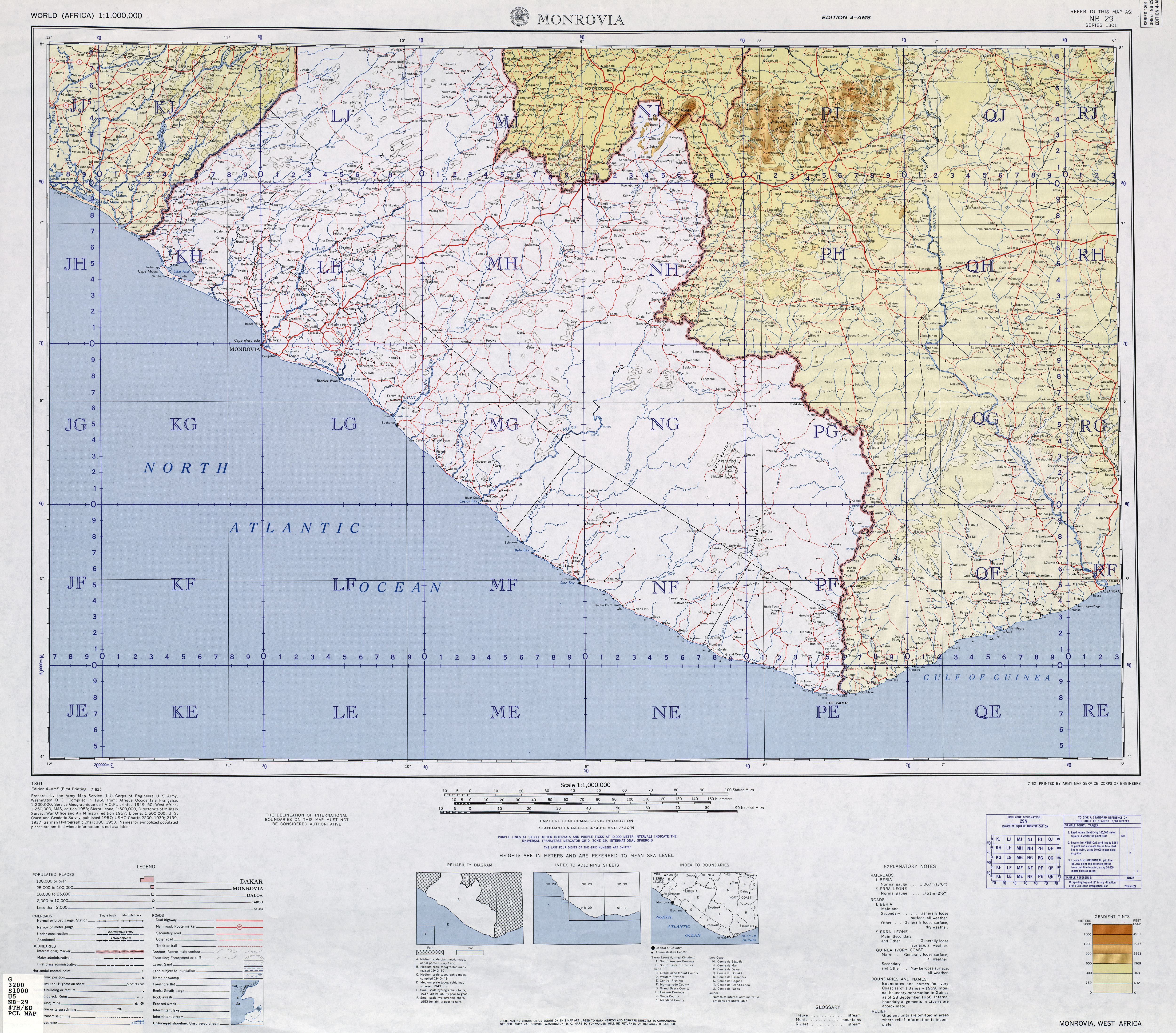
- TK250 NB29-4 (MONROVIA) , US Army Map Service (Ed.), Washington 1960, (Course in Liberia)
Individual evidence
- ^ A b c d Liberian Hydrological Services - St. Paul River Principal Basin Tables, Figures and Maps
- ↑ a b Flow rates on Liberian Hydrological Services
- ^ United Nations Environment Program (UNEP), January 20 - Transboundary River Basins Status and Trends
- ^ Liberia - Country and Road Detail Maps, sheet NB29–5E. (PDF; 1.5 MB) (No longer available online.) In: The PUREONE Org. Archived from the original on May 18, 2015 ; Retrieved January 20, 2011 . Info: The archive link was inserted automatically and has not yet been checked. Please check the original and archive link according to the instructions and then remove this notice.
- ^ Saint Paul River. In: Encyclopædia Britannica (Online). Retrieved January 22, 2011 .
- ^ Saint Paul River (2221). (No longer available online.) In: River Discharged Database, G.Nelson Inst. Archived from the original on June 16, 2010 ; Retrieved January 22, 2011 . Info: The archive link was inserted automatically and has not yet been checked. Please check the original and archive link according to the instructions and then remove this notice.
- ^ Liberia: Geological Background. (No longer available online.) In: Liberty International Mineral Corporation. Archived from the original on March 14, 2016 ; Retrieved January 22, 2011 . Info: The archive link was inserted automatically and has not yet been checked. Please check the original and archive link according to the instructions and then remove this notice.
- ^ Wetlands in Liberia. (PDF; 296 kB) (No longer available online.) In: RAMSAR database. Formerly in the original ; Retrieved January 20, 2011 . ( Page no longer available , search in web archives ) Info: The link was automatically marked as defective. Please check the link according to the instructions and then remove this notice.