San Miguel de Allende
| San Miguel de Allende | ||
|---|---|---|
|
Coordinates: 20 ° 55 ′ N , 100 ° 45 ′ W San Miguel de Allende on the map of Guanajuato
|
||
| Basic data | ||
| Country | Mexico | |
| State | Guanajuato | |
| Municipio | San Miguel de Allende | |
| City foundation | 1542 | |
| Residents | 69,811 (2010) | |
| City insignia | ||
| Detailed data | ||
| surface | 23.3 km 2 | |
| Population density | 2,996 inhabitants / km 2 | |
| height | 1907 m | |
| Post Code | 37700-37898 | |
| Website | ||
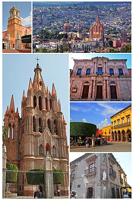
| Cityscape and buildings of San Miguel de Allende | ||
San Miguel de Allende is a city with about 80,000 inhabitants in the Mexican state of Guanajuato ; it is also the administrative seat of the municipality of the same name ( municipio ) with approx. 175,000 inhabitants. The city has been a UNESCO World Heritage Site since 2008 ; before that, San Miguel de Allende was one of the Pueblos Mágicos (“Magical Places”).
Location and climate
The city of San Miguel de Allende is located on the Río Laja about 275 km (driving distance) northwest of Mexico City at an average altitude of about 1900 m ; the city of Guanajuato is just under 55 km to the west. The climate is warm; Rain (approx. 545 mm / year) falls predominantly in the summer half-year.
Population development
| year | 2000 | 2005 | 2010 |
| Residents | 59,691 | 62,034 | 69,811 |
The slight but steady increase in population is mainly due to the ongoing immigration of families from the surrounding villages. About 10 to 15% of the population are foreigners (mostly North American retirees).
economy
Livestock raising (cattle, sheep, goats, pigs) plays the most important role in the life of the community; In addition, the cultivation of grain (maize, wheat, barley) and the cultivation of fruit and vegetables (beans, chillies, tomatoes, prickly pears, peaches, pears, figs, etc.) are important. Small traders, craftsmen and service providers of all kinds have settled in the city itself.
history
The region around San Miguel belonged to the tribal area of the predatory Guachichil Indians, a subgroup of the Chichimecs . In 1542 the city was founded by a Franciscan as San Miguel el Grande ; even then it was an important stopover on the Camino Real de Tierra Adentro , which led from Mexico City to the “silver cities” of the north. In 1826 the city was renamed San Miguel de Allende ; this was done in honor of General Ignacio Allende , who came from San Miguel and played an important role in the fight against the Spaniards in the Mexican War of Independence .
Attractions
- Plaza de Allende
- Parroquia de San Miguel Arcángel (Cathedral), was built in pink stone and Gothic style in the 17th century and rebuilt in 1880 based on the Ulm Minster .
- San Francisco Church , built in the Churriguera style.
- San Felipe Neri Church , built of pink stone in the Rococo style.
- Ignacio Allende's house, now houses a museum.
San Miguel de Allende is popular with artists, especially from the USA , who have settled here.
On 7 July 2008 the fortified town of San Miguel, together with the Jesuit Sanctuary of Jesús Nazareno de Atotonilco by the UNESCO for World Heritage declared. It was recognized that both are outstanding examples of the Mexican baroque and for the exchange between Spanish and Latin American culture.
sons and daughters of the town
- Ignacio Allende (1769–1811), insurgent and revolutionary
- Juan José de los Reyes Martínez Amaro ( El Pípila ) (1782–1863), miner and Mexican national hero
- Federico Montes Alanís (1884–1950), politician and ambassador
- Pedro Vargas (1904-1989), singer
- José Luis Caballero (1922–2009), singer


